System and method for location-based sharing of information and location-based response to the shared information

a technology of location-based sharing and information, applied in the field of system and method for location-based sharing of information and location-based response to the shared information, can solve the problems of limited and disadvantageous of the above-described crisis mapping tools, difficult to organize the numerous amounts of data and information received from social media platforms, and determine the location of victims, etc., to achieve the effect of limiting the benefit of crisis mapping tools

Inactive Publication Date: 2018-06-21
HASHINGTON GCV
View PDF0 Cites 32 Cited by
  • Summary
  • Abstract
  • Description
  • Claims
  • Application Information

AI Technical Summary

Benefits of technology

[0006]The use of the platform may be as ubiquitous as calling 911, 112, or shouting for help. The platform is more expansive than a predefined network of friends, and thus, the sharing, broadcasting, and / or publishing user may be able to share, broadcast, and / or publish information to any user of the platform, such as to people that the sharing, broadcasting, and / or publishing user may not know or not have connected with on social media. In at least that regard, the platform may empower a community of users to help and provide assistance to each other. Moreover, the platform may allow bystanders and / or witnesses to assist users in need by posting relevant information to the platform for other users to see.
[0007]Unlike the crisis mapping tools described above, the platform of the present disclosure allows the information to originate directly from a victim needing assistance and also allows a responder to directly communicate with the victim without the victim and the responder having to have a predefined relationship.

Problems solved by technology

The above-described crisis mapping tools, however, are limited and disadvantageous in numerous ways.
First, the primary source of information originates from the people that merely witness the crisis or incident (typically via social media platforms) and not from the people who are directly affected by the crisis or incident.
It is also difficult to organize the numerous amounts of data and information received from the social media platforms, determine where the victims are located, and determine how to specifically help those victims.
Second, the benefit of crisis mapping tools is limited by the people subscribed to the crisis mapping services and / or the limited number of people certified and approved by the services to render assistance.
Third, users are required to download applications or sign-up for the crisis mapping services before use, which is a severe limitation for users who have not downloaded the applications or have signed up when a crisis or incident actually occurs.
Moreover, crisis mapping tools are typically used only for urgent situations.

Method used


Image

  • System and method for location-based sharing of information and location-based response to the shared information
  • System and method for location-based sharing of information and location-based response to the shared information
  • System and method for location-based sharing of information and location-based response to the shared information

Examples


Embodiment Construction

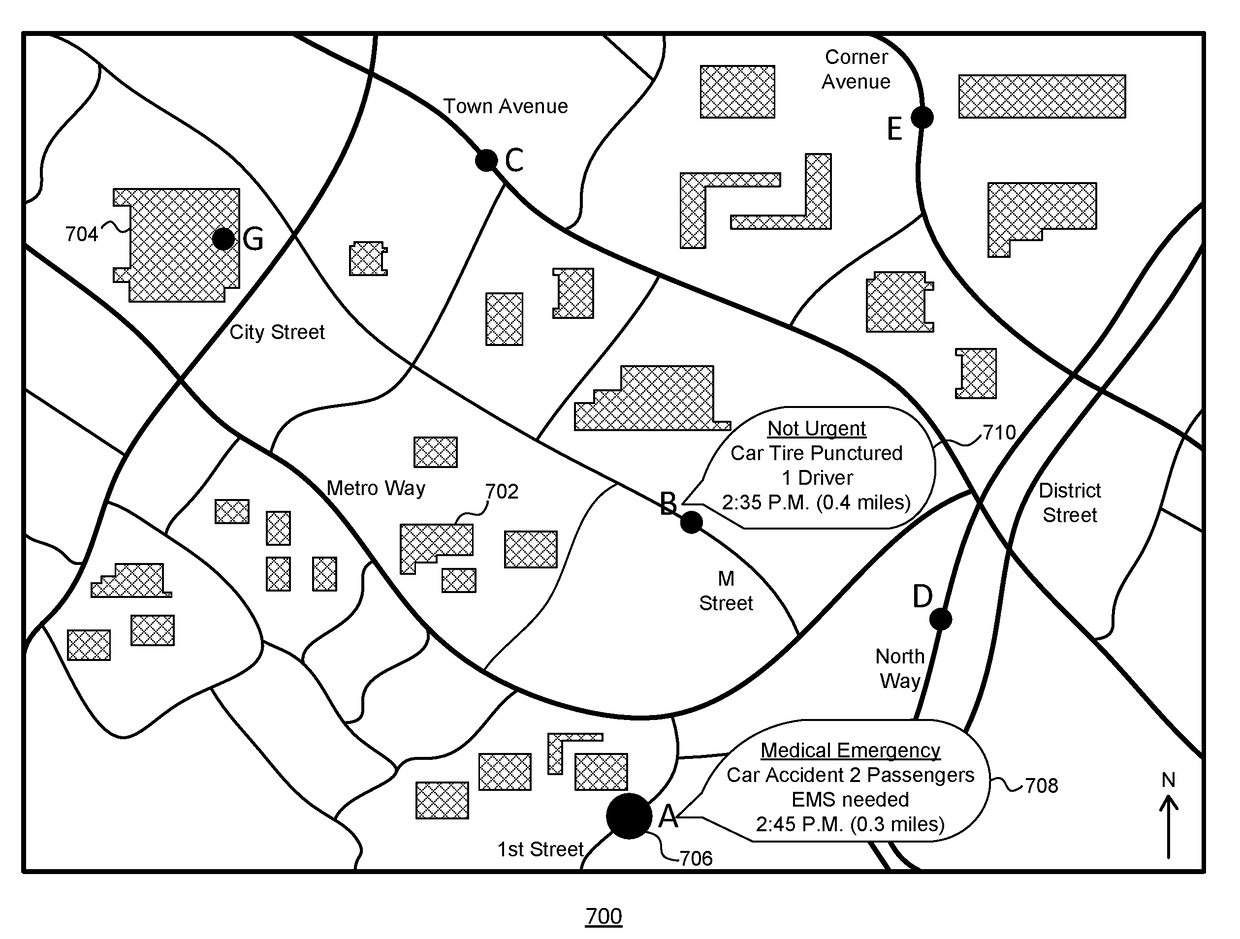
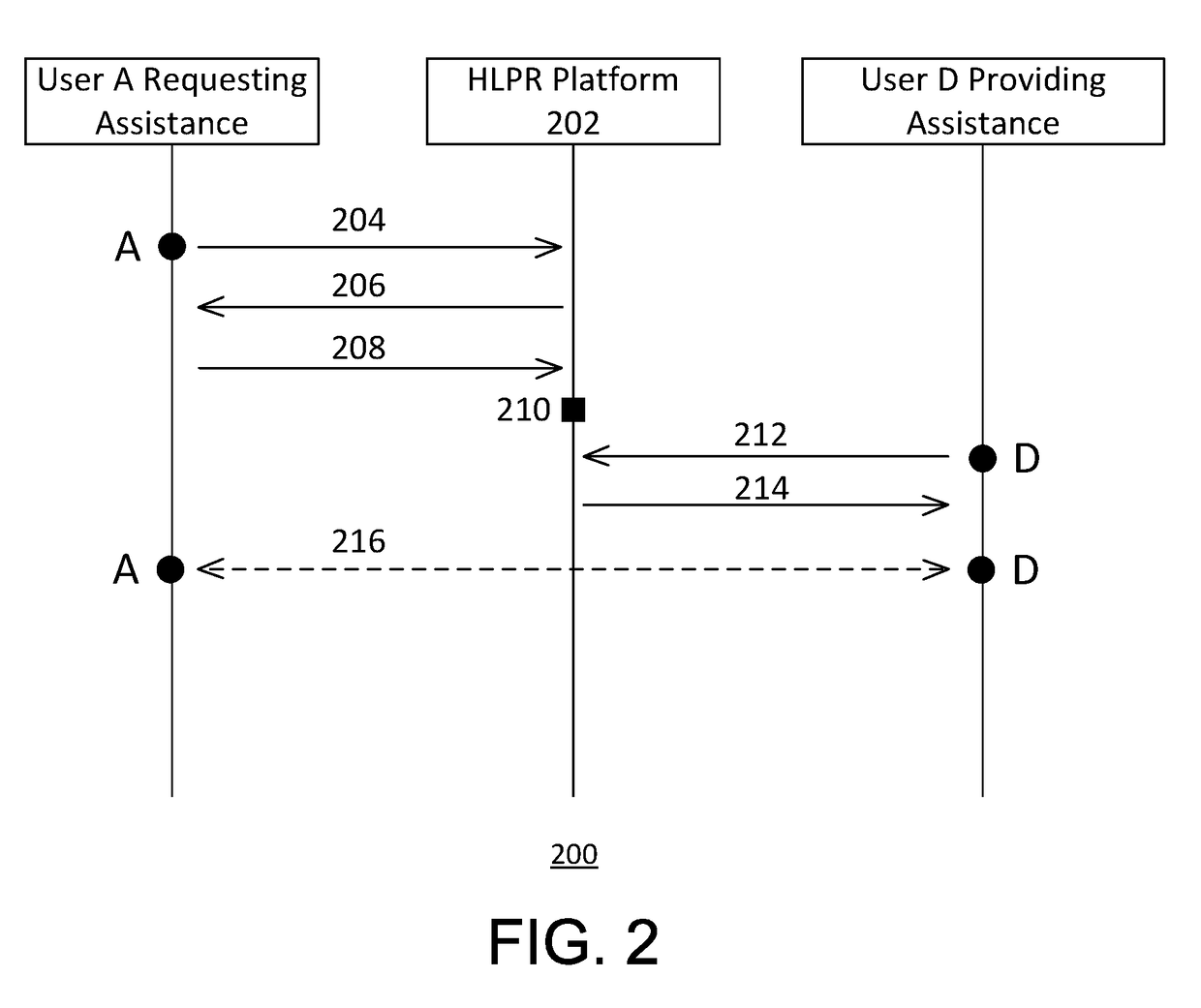
[0013]The invention relates to a system and method for sharing, broadcasting, and / or publishing information by a user from a location in real-time and allowing one or more users in near that location to directly respond to and directly communicate with the sharing, broadcasting, and / or publishing user. The information may be a request for assistance related to an emergency or a non-urgent matter.

[0014]In one example, a driver may have inadvertently crashed his or her vehicle into a stationary object, such as a tree. Although the driver is conscious, the driver is trapped in the vehicle and has suffered numerous injuries. Moreover, the driver may not know the exact geographical location of the accident, nor does the driver know nearby cross streets due to the driver's unfamiliarity with the area.

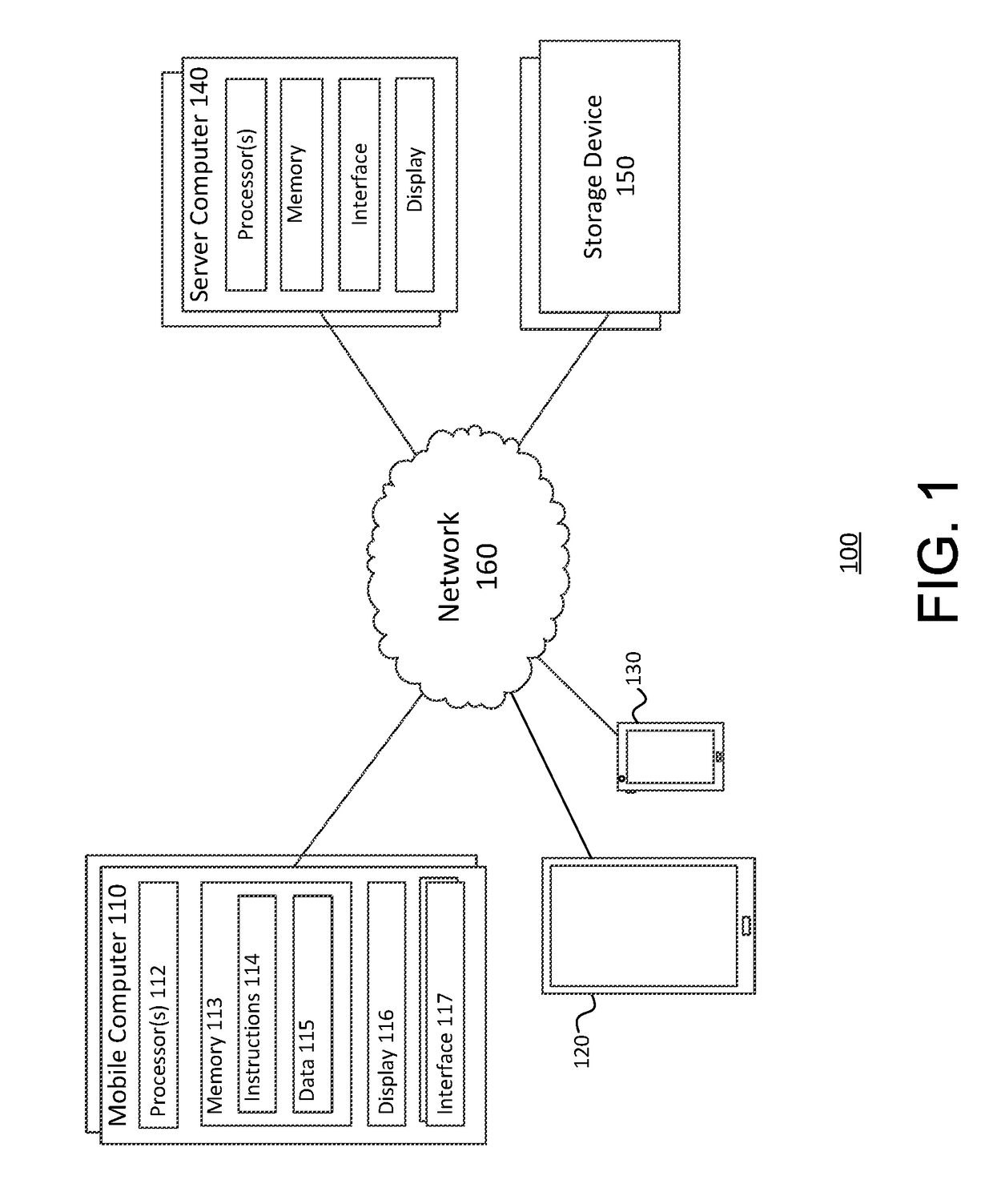
[0015]To request help, the driver may use his or her mobile device to connect to a platform (hereinafter referred to as the “HLPR” platform) by opening a web browser (for retrieving, presenti...


PUM


Abstract

The disclosure is directed to a system and method for sharing, broadcasting, or publishing information by a user from a location in real-time and allowing one or more users near that location to directly respond to and directly communicate with the sharing, broadcasting, or publishing user. A computing device, for example, may receive a request for assistance from a first user computing device and determine a geographical location corresponding to the first user computing device. The computing device may publish the geographical location. The computing device may also receive a response to the request for assistance from a second user computing device and may determine whether the response indicates a request to establish communication with the first user computing device. Based on the determination, the computing device may establish direction communication between the first user computing device and the second user computing device.

Description

BACKGROUND ART[0001]The invention relates to a system and method for sharing, broadcasting, and / or publishing information by a user from a location in real-time and allowing one or more users near that location to directly respond to and directly communicate with the sharing, broadcasting, and / or publishing user.[0002]Crisis mapping is the real-time gathering, display, and analysis of data during a crisis, such as a natural disaster and social or political conflict, e.g., violence, protests, etc. Projects involving crisis mapping allow a large number of people, including crisis responders and the general public, to contribute information either remotely or from the site of the crisis. In that regard, crisis mapping encourages the public to engage and report information related to the crises, which can improve data management. Crisis mappers may work with data derived from various sources and can be analyzed for different purposes. Tools for crisis mapping include mobile and web-base...

Claims


Application Information

Patent Timeline
Patent Type & Authority Applications(United States)
IPC IPC(8): H04L29/06H04L12/58
CPCH04L65/4007H04W64/00H04L51/046H04L12/1845G06Q90/205G06Q10/06G06Q50/01G06Q50/26H04W76/14H04L51/222H04L67/52
Inventor LAURENT, CHRISTOPHE
Owner HASHINGTON GCV
Why Eureka
Try Eureka