Method and apparatus for creating an optimized localization map and method for creating a localization map for a vehicle

a technology for optimizing localization and creating localization maps, which is applied in the direction of navigation instruments, using reradiation, instruments, etc., can solve the problems of inaccurate localization maps generated by vehicle reading-in units or vehicle sensor systems, and achieve high-quality positions

Active Publication Date: 2019-05-09
ROBERT BOSCH GMBH
View PDF6 Cites 6 Cited by
  • Summary
  • Abstract
  • Description
  • Claims
  • Application Information

AI Technical Summary

Benefits of technology

[0006]A “landmark” can be understood as any static object that can serve for vehicle localization and / or navigation, for instance infrastructure elements such as road signs or street light poles or gantry signs. An “optimized localization map” can be understood as a map in which at least one position of a landmark has been determined by considering the position from the radar map and the position from the localization map. That determined position is then usually very close to the actual geographic position of the landmark. The method presented here thus serves to optimize localization maps using radar maps. This is useful because localization maps that have been generated, for example, by way of vehicle sensor signals of vehicle reading-in units on vehicles or sensor systems on vehicles are often inaccurate. Because, as a result of the approach presented, even inaccurate localization maps can serve for creation of the highly accurate optimized localization map, cost-intensive vehicle reading-in units are not needed in vehicles in order to create the localization maps.
[0009]In the reading-in step, a radar map furnished by way of a TerraSAR-X satellite can be read in as a radar map; in particular, a further position of the landmark, sensed by radar, is read into the radar map. This satellite supplies highly accurate positions of landmarks which can serve ideally as orientation values for generating the modified positions.
[0014]Also presented here is an apparatus that has units or interfaces embodied to implement and / or execute the steps of an embodiment of the method presented here. This variant embodiment of the approach in the form of an apparatus also makes it possible to achieve, quickly and efficiently, the object on which the approach is based.

Problems solved by technology

This is useful because localization maps that have been generated, for example, by way of vehicle sensor signals of vehicle reading-in units on vehicles or sensor systems on vehicles are often inaccurate.
Because, as a result of the approach presented, even inaccurate localization maps can serve for creation of the highly accurate optimized localization map, cost-intensive vehicle reading-in units are not needed in vehicles in order to create the localization maps.

Method used


Image

  • Method and apparatus for creating an optimized localization map and method for creating a localization map for a vehicle
  • Method and apparatus for creating an optimized localization map and method for creating a localization map for a vehicle
  • Method and apparatus for creating an optimized localization map and method for creating a localization map for a vehicle

Examples


Embodiment Construction

[0024]In the description below of favorable exemplifying embodiments of the present approach, identical or similar reference characters are used for elements that function similarly and are depicted in the various Figures, repeated description of those elements being omitted.

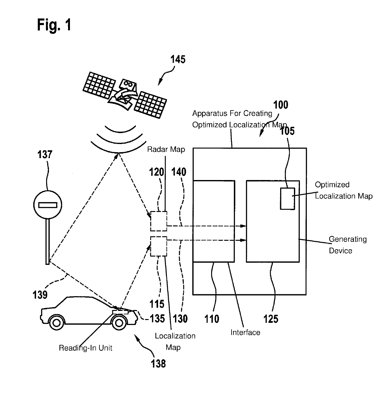
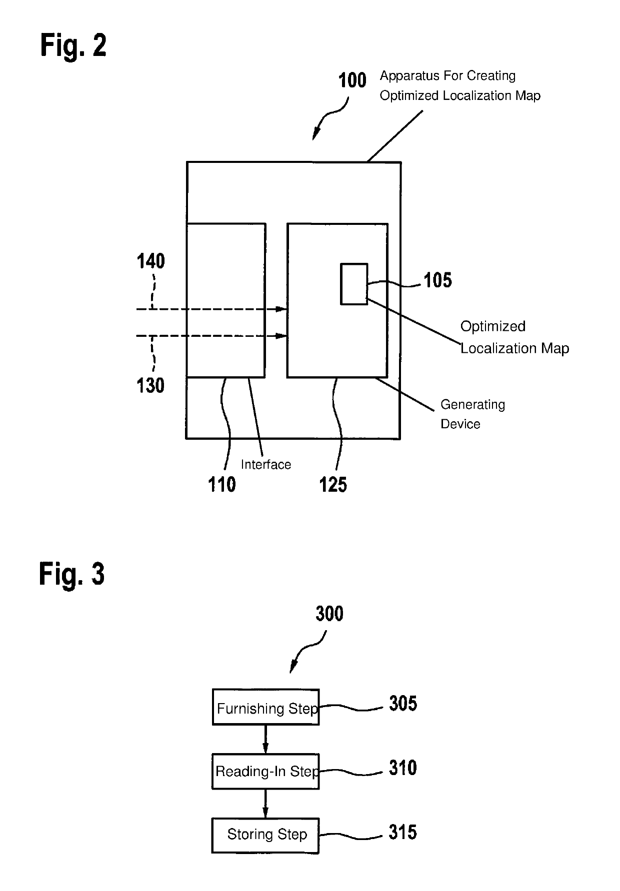
[0025]FIG. 1 schematically depicts an apparatus 100 for creating an optimized localization map 105, in accordance with an exemplifying embodiment. Apparatus 100 encompasses an interface 110 for reading in a localization map 115, an interface 110 for reading in a radar map 120, and a generating device 125. In accordance with this exemplifying embodiment, apparatus 100 encompasses only one reading-in interface 110, which is embodied to serve as interface 110 for reading in both localization map 115 and radar map 120. According to an alternative exemplifying embodiment, apparatus 100 can also have two separate interfaces 110 for reading in localization map 115 and radar map 120.

[0026]Interface 110 for reading in lo...


PUM


Abstract

The approach presented here relates to a method for creating an optimized localization map for a vehicle. The method encompasses a step of furnishing at least one localization map that represents at least one position, read in by a vehicle reading-in unit, of a landmark. The method further encompasses a step of reading in a radar map via an interface, the radar map having or mapping at least one further position, furnished by way of radar measurement by a satellite, of the landmark in the radar map. Lastly, the method encompasses a step of generating and storing an optimized localization map using the localization map and the radar map, such that upon generation of the optimized localization map, the read-in position of the landmark is altered using the further position to yield a modified position of the landmark, and is stored in order to create the optimized localization map.

Description

FIELD OF THE INVENTION[0001]The approach proceeds from an apparatus or a method. A further subject of the present approach is a computer program.BACKGROUND INFORMATION[0002]Advanced driver assistance systems (ADAS) and highly automated vehicle systems for urban automated driving (UAD) require increasing levels of situation awareness and detailed knowledge about vehicle surroundings. Accurate localization is necessary for this purpose. Apparatuses exist for extracting landmarks from aerial images of roads. Those landmarks are stored in a map and then used for vehicle localization.SUMMARY[0003]In light of the above, the approach presented here presents a method for creating an optimized localization map, furthermore an apparatus that uses that method, a method for creating a localization map, and lastly a corresponding computer program.[0004]A method for creating an optimized localization map for a vehicle is presented, the method encompassing at least the following steps:furnishing a...

Claims


Application Information

Patent Timeline
Patent Type & Authority Applications(United States)
IPC IPC(8): G01C21/32G06F16/29G01S19/48G01S13/89
CPCG01C21/32G06F16/29G01S19/48G01S13/89G01S17/88G01S7/4808G01S13/90G01S2013/9322G01S13/9027G01C21/3811G01C21/3848G01C21/3841
Inventor MIELENZ, HOLGERROHDE, JAN
Owner ROBERT BOSCH GMBH
Why Eureka
Try Eureka