Correlating event data for large geographic area

a technology for correlating event data and large geographic area, applied in the field of data correlation, can solve problems such as multiple coordinated terrorist attacks in the world

Inactive Publication Date: 2007-11-20
THE UNITED STATES OF AMERICA AS REPRESENTED BY THE SECRETARY OF THE NAVY
View PDF11 Cites 73 Cited by
  • Summary
  • Abstract
  • Description
  • Claims
  • Application Information

AI Technical Summary

Benefits of technology

[0016]A plurality of statistical analyses are performed using the raw data packages. Each statistical analysis is based on one of a plurality of unique time periods such that each statistical analysis relates ones of the raw data packages occurring in a most recent one of the unique time periods to ones of the raw data packages occurring in historical ones of the unique time periods. Results of the statistical analyses are stored and used in the performance of a plurality of correlations in order to identify at least one of the following:

Problems solved by technology

On a local level, defense, security and law enforcement agencies spend a lot of time and effort to protect sensitive sites or those located in hostile regions.
However, in recent history, the world has been subjected to multiple coordinated terrorist attacks occurring close in time at multiple locations.
However, when examined collectively, these geographically-dispersed pre-event activities produced patterns in windows of time that clearly represented highly suspicious activity warranting immediate attention.

Method used


Image

  • Correlating event data for large geographic area
  • Correlating event data for large geographic area
  • Correlating event data for large geographic area

Examples


Embodiment Construction

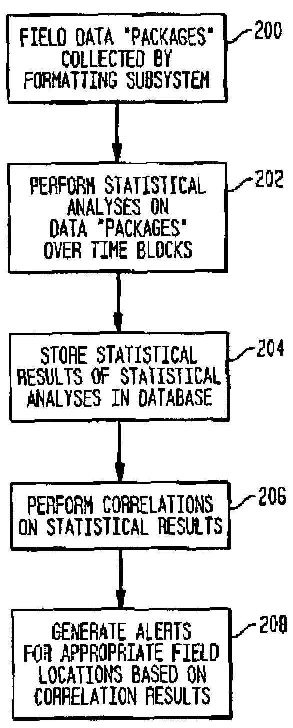
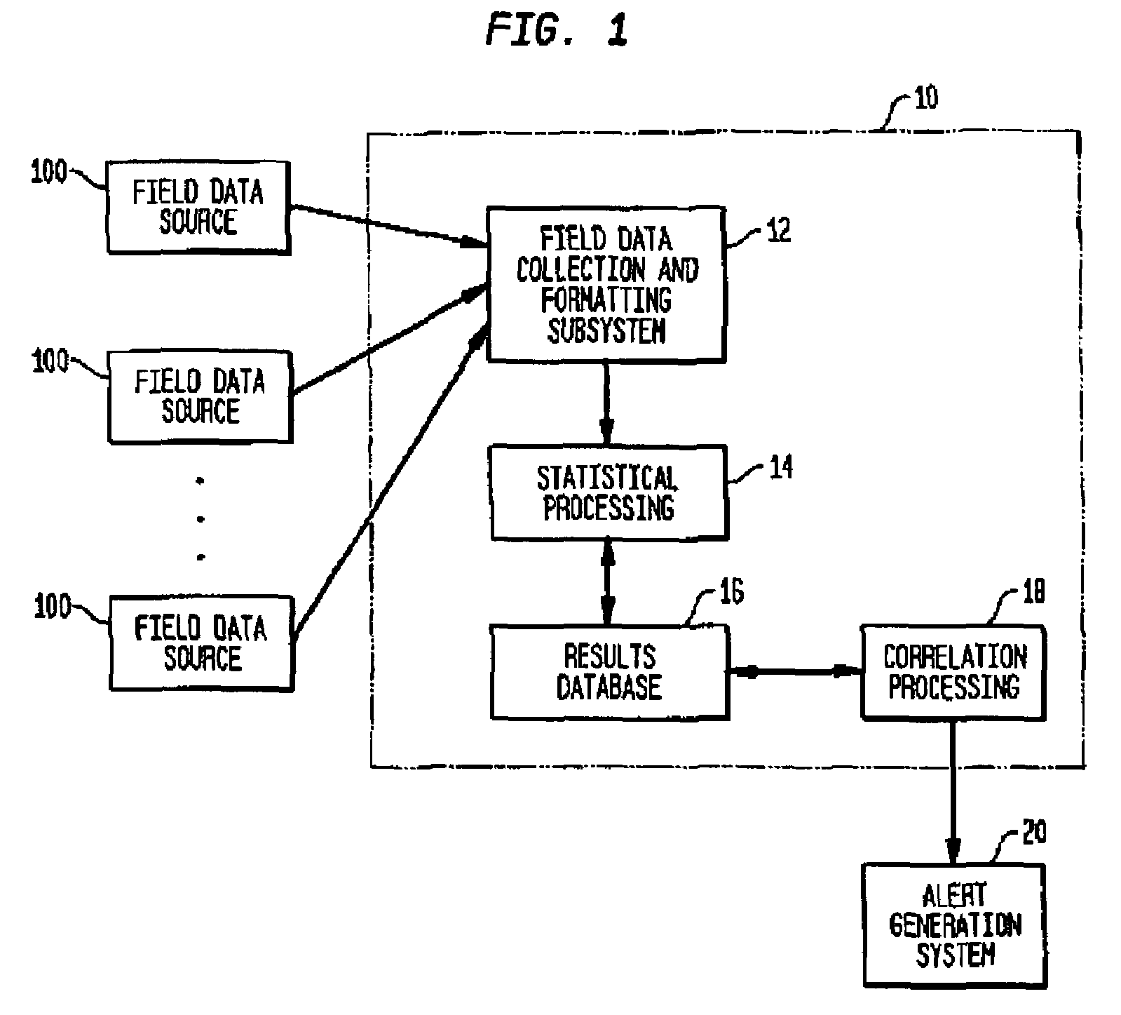
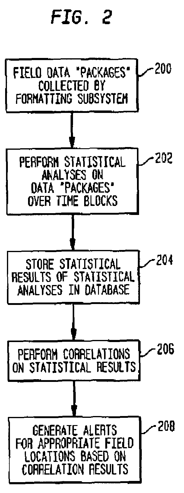
[0023]Referring now to the drawings, simultaneous reference will be made to FIGS. 1 and 2 where FIG. 1 is a top-level system diagram and FIG. 2 is a top-level flow diagram in accordance with the present invention. In FIG. 1, a system for monitoring and analyzing geographically-dispersed event data in accordance with the present invention is shown within the dashed line box referenced by numeral 10. As used herein, the term “geographically-dispersed” refers to geographic locations dispersed (i.e., separated by distances of hundreds or thousands of yards up to tens, hundreds or thousands of miles) over large geographic areas such as a country, a continent, or multiple continents. The term “location” is used herein to refer to any government installation or building, or any civilian installation or building. Examples of such locations include, but are not limited to, military compounds, government buildings, embassies, airports, financial centers, mass transportation facilities, ports,...


PUM


Abstract

Event data associated with possible terrorist activities occurring at geographically-dispersed locations is monitored and analyzed. Event data collected from the locations is delineated by one or more data classes. Statistical analyses performed on the event data are based on one of a number of unique time periods or blocks. Results of the statistical analyses are used in the performance of a number of correlations in order to identify patterns occurring in the data classes and/or correlations between the data classes.

Description

ORIGIN OF THE INVENTION[0001]The invention described herein was made in the performance of official duties by an employee of the Department of the Navy and may be manufactured, used, licensed by or for the Government for any governmental purpose without payment of any royalties thereon.FIELD OF THE INVENTION[0002]The invention relates generally to data correlation, and more particularly to correlating event data associated with activities of concern occurring at a plurality of locations dispersed over a large geographic area.BACKGROUND OF THE INVENTION[0003]On a local level, defense, security and law enforcement agencies spend a lot of time and effort to protect sensitive sites or those located in hostile regions. Thus, a variety of systems and methods exist and are being developed to improve security at individual sites. However, in recent history, the world has been subjected to multiple coordinated terrorist attacks occurring close in time at multiple locations. Post-event analys...

Claims


Application Information

Patent Timeline
Patent Type & Authority Patents(United States)
IPC IPC(8): G06F19/00
CPCG08B31/00G08B19/00G06F19/3493G16H50/80
Inventor MORITZ, ELAN
Owner THE UNITED STATES OF AMERICA AS REPRESENTED BY THE SECRETARY OF THE NAVY
Why Eureka
Try Eureka