
Photoelectric detection system based ground vehicle accurate positioning orientation method

A photoelectric detection and precise positioning technology, applied in the field of navigation and positioning, can solve the problem that the positioning and orientation accuracy of the land navigation system cannot meet the requirements of specific tasks, and achieve the effect of eliminating susceptible to interference, ensuring the success rate, and improving the level of positioning and orientation accuracy.

Inactive Publication Date: 2009-10-21
BEIHANG UNIV
View PDF3 Cites 0 Cited by
  • Summary
  • Abstract
  • Description
  • Claims
  • Application Information

AI Technical Summary

Problems solved by technology

[0004] The technical problem of the present invention is to provide a method for quickly and accurately determining the position and heading of ground vehicles using the photoelectric detection system in view of the fact that the positioning and orientation accuracy of the existing land navigation system cannot meet the requirements of specific tasks

Method used


Image

  • Photoelectric detection system based ground vehicle accurate positioning orientation method
  • Photoelectric detection system based ground vehicle accurate positioning orientation method
  • Photoelectric detection system based ground vehicle accurate positioning orientation method

Examples


Embodiment Construction

[0015] The specific implementation process of the present invention will be described below by taking the situation in the plane coordinate system as an example.

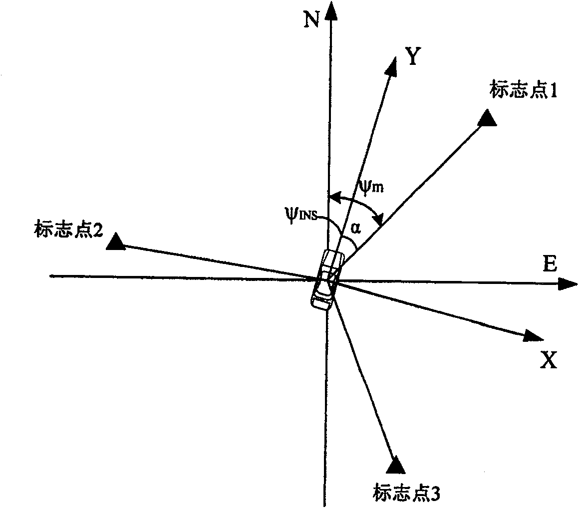
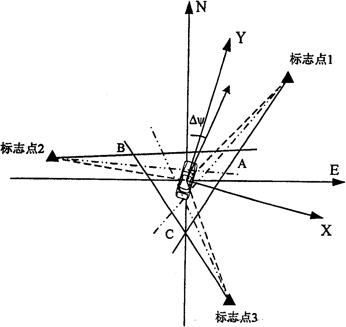
[0016] Fig. 1 has provided the schematic diagram of principle of the present invention, in Figure 1A In , the ground vehicle is located at the origin of the coordinates, and the true heading points to the north. When the initial heading angle has no error, the three straight lines determined by the positions and azimuths of the three marker points will intersect at one point, that is, the true position of the vehicle. And when there is an error in the initial heading angle, the three straight lines no longer intersect at one point, but intersect at three points, such as Figure 1B shown.

[0017] Assume that the ground vehicle is located at the origin of the coordinates, that is (x, y) = (0, 0), and the true heading is north, that is, ψ T =0°, the positions of the mark points are respectively (x Li ,y Li )(i=1, ...


PUM


Abstract

Ground vehicle precise positioning and orientation method based on photoelectric detection system: the vehicle is equipped with an inertial navigation system INS or DR system and a photoelectric detection system, so that the vehicle stops after entering the correction area, and the position and heading of the INS or DR system at this time are used as the vehicle's direction Initial position and initial heading angle; use the photoelectric detection system to measure the angles between the three marker points and the vehicle in sequence, and obtain the azimuth angles of the three marker points from the initial heading angle of the vehicle; The obtained azimuth angle makes three straight lines and submits an error triangle, thereby estimating the position and heading angle errors of the INS or DR system; finally, the output of the on-board INS or DR system is corrected to improve the positioning and orientation accuracy. The invention does not rely on GPS, is very simple and fast to implement, and can serve multiple ground vehicles at the same time, providing a new technical approach for the rapid and accurate positioning and orientation of ground vehicles before performing tasks.

Description

technical field [0001] The invention relates to a method for accurately determining the position and heading of a ground vehicle by using a vehicle-mounted photoelectric detection system to measure angle information between three known marker points and a ground vehicle, and belongs to the technical field of navigation and positioning. Background technique [0002] Modern warfare has put forward higher and higher requirements for the combat performance of vehicles and weapons (such as self-propelled artillery, tanks, armored vehicles, etc.) that undertake combat tasks. They must have good mobility and flexibility, and at the same time need to know where they are Position and direction, so as to achieve organic joint defense and effective strike against the enemy. Therefore, the Land Navigation System (LNS, Land Navigation System) has become an important part of the modernization of army equipment in developed countries in the world. LNS is the basic element of informationiz...

Claims


Application Information

Patent Timeline
Patent Type & Authority Patents(China)
IPC IPC(8): G01C21/26G01C21/28G01C21/20G01C21/16
Inventor 冯培德王玮王丹高文
Owner BEIHANG UNIV
Learn More