Surveying procedure and system for a high-rise structure

A technology of the highest, coordinate system, applied in the field of survey and system of high-rise structures, can solve problems such as difficulty and complexity of instruments

Active Publication Date: 2009-02-04
LEICA GEOSYSTEMS AG
View PDF2 Cites 11 Cited by
  • Summary
  • Abstract
  • Description
  • Claims
  • Application Information

AI Technical Summary

Problems solved by technology

The situation is compounded by building vibrations from construction and building m

Method used


Image

  • Surveying procedure and system for a high-rise structure
  • Surveying procedure and system for a high-rise structure

Examples


Embodiment Construction

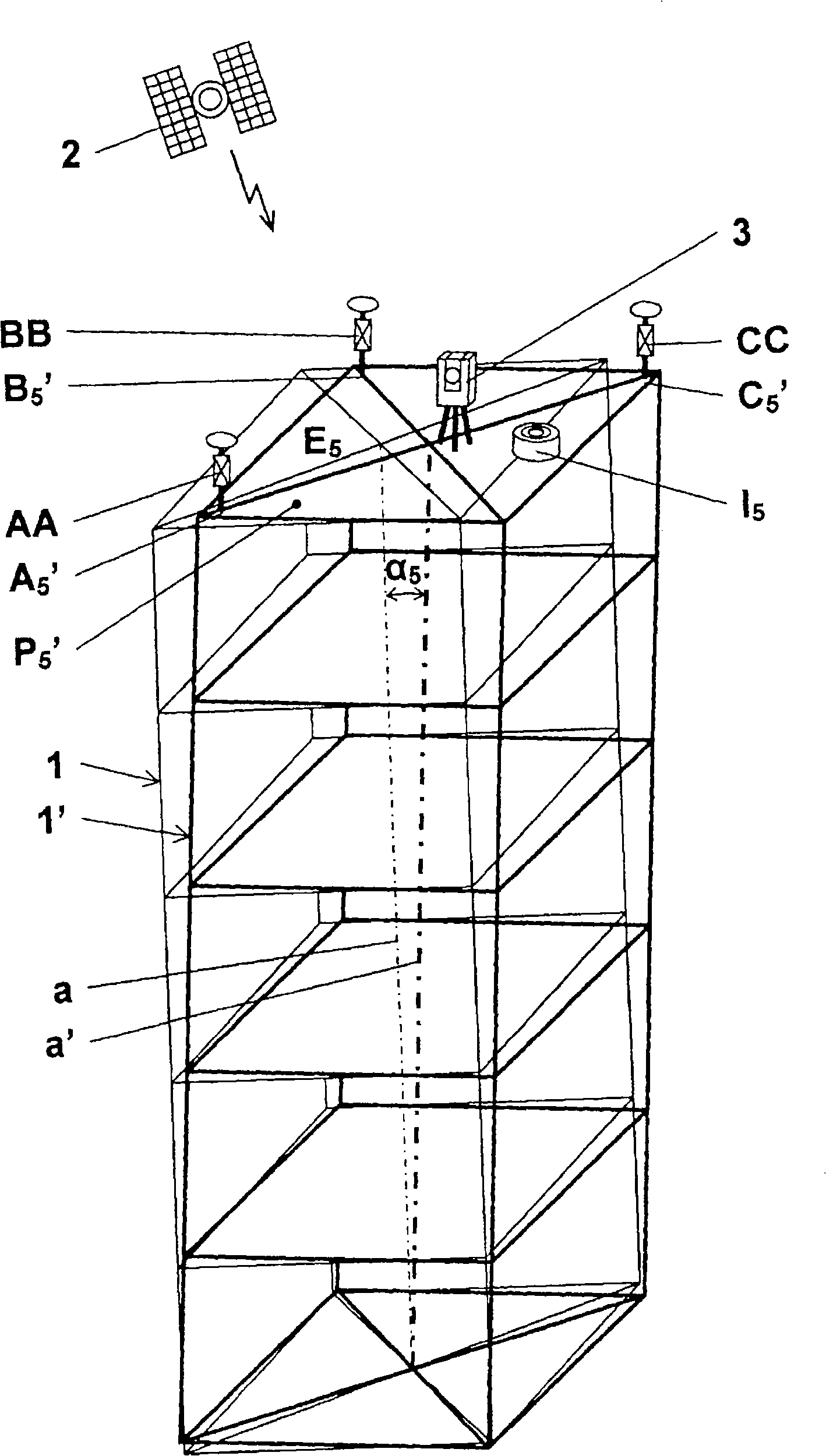
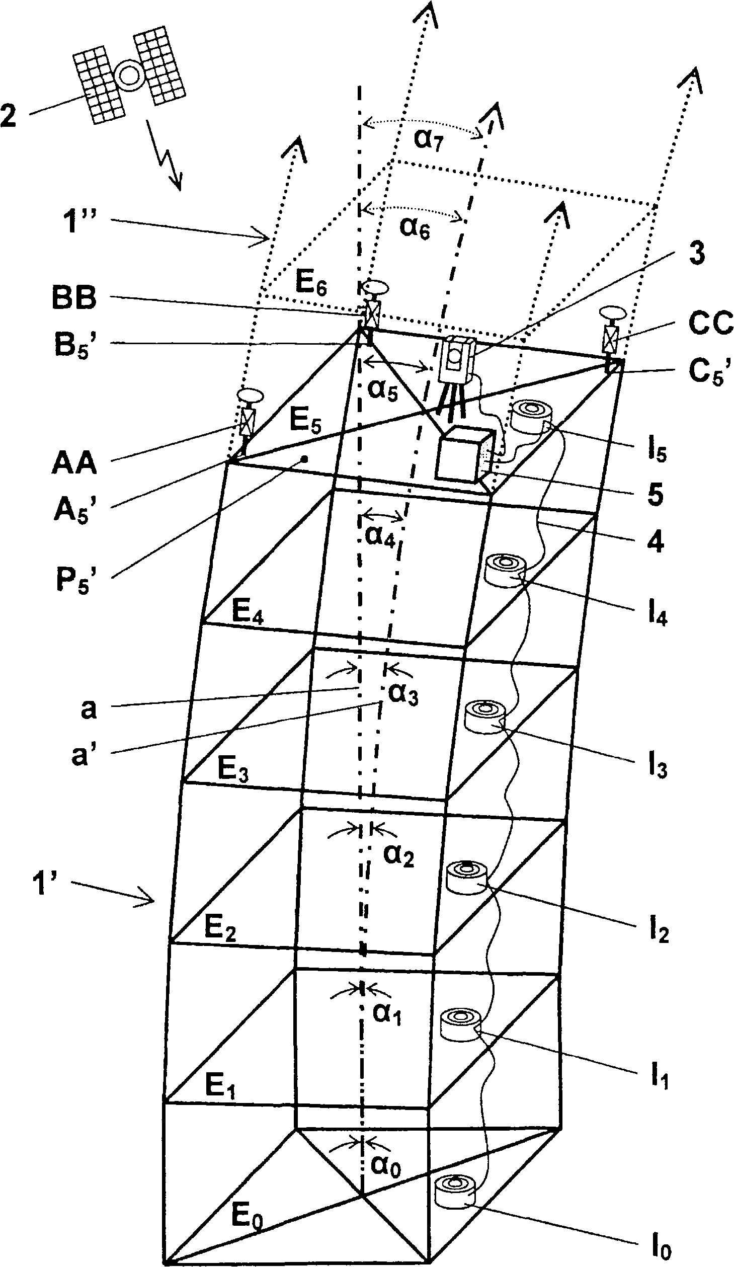
[0015] figure 1 shows a structure 1', i.e. a partially erected building, in its actual tilted state, with a straight actual line a' relative to a theoretically untilted structure 1 with an ideal axis "a", whereas figure 2 Structure 1' is shown in a tilted state with 5 The curved actual line a' simulated for the structure 1" to be built. In the following, the figure 1 and figure 2 will be put together to describe.

[0016] The invention relies on the use of at least three receivers AA, BB, CC of a satellite positioning system 2 to determine three reference points A 5 ', B 5 ', C 5 ' (more specifically, a reference point equipped with a reflector) on the current building top floor of an untilted structure 1 or a tilted structure 1' under construction located within the satellite reception area E. 5 superior. For example, each receiver AA, BB, CC is mounted on a reflector and placed at reference point A 5 ', B 5 ', C 5 ’ on the pillars. A particularly suitable satel...


PUM


Abstract

The invention concerns a surveying procedure for a structure (1'), more particularly a high-rise building, to be erected which has an ideal axis (a) oriented relative to the gravity vector. At least three reference points (A5', B5', C5') are defined by receivers (AA, BB, CC) of a satellite-based positioning system (2), on the uppermost construction level (E5) of the structure (1'). The position of an electro-optical geodesic instrument (3) assigned to the structure (1') is determined relative to the three reference points (A5', B5', C5') and to a singular point (P5') of structure (1'). The tilt (a5) of a real line (a') developing from the ideal axis (a) under tilt effects acting on the structure (1; 1') is acquired gravimetrically, more particularly with a gravimetric tilt sensor (I5). A static coordinate system tied to ideal axis (a) is transformed to a coordinate system tied to real line (a') and depending dynamically on tilt (a5) , by adducing the at least three reference points (A5', B5', C5') , the relative position of the geodesic instrument (3), and the tilt (a5) of real line (a') . By the repetitive steps of gravimetric acquisition of tilt (a5) of real line (a') and of referencing and matching of the geodesic instrument (3) to the coordinate system that dynamically depends on tilt (a5), a precise and reliable surveying procedure can be provided for a structure (1; 1') of almost any height, and more particularly for a high-rise building, that is to be erected and is subject to tilt effects, and hampers the use of ground-level reference points.

Description

technical field [0001] The invention relates to a method of surveying for buildings to be constructed, more particularly for high-rise buildings, according to the preamble of claim 1 and a method for locating (reference) buildings according to the preamble of claim 7 and match the coordinate transformation system of at least one geodetic surveying instrument. Background technique [0002] Various methods and devices for surveying during and after the construction of tall buildings are known from the prior art. High-rise buildings are susceptible to strong external tilting effects caused, for example, by wind pressure, one-sided heating effects from exposure to sunlight and one-sided loads. Because tall buildings are also susceptible to tilting effects during construction and will deviate, at least temporarily, from their normally perfectly vertical alignment, such tilting effects are critical to the construction process of tall buildings. A special kind of challenge. Howe...

Claims


Application Information

Patent Timeline
IPC IPC(8): G01C15/00G01S19/04G01S19/10G01S19/44G01S19/46
CPCG01C15/00G01C7/02G09B25/06G09B29/003
Inventor 约耳·范克莱恩布洛克
Owner LEICA GEOSYSTEMS AG
Why Eureka
Try Eureka