
Road shape estimating device, road shape estimating method and program

A road and processing device technology, applied to road network navigators, two-dimensional position/channel control, etc., can solve the problem that the road shape cannot be estimated correctly, and achieve the effect of correct road shape

Inactive Publication Date: 2009-09-30
AISIN AW CO LTD
View PDF1 Cites 1 Cited by
  • Summary
  • Abstract
  • Description
  • Claims
  • Application Information

AI Technical Summary

Problems solved by technology

[0007] However, in the above-mentioned conventional road shape estimating device, a curve that should be regarded as a plurality of curves on an actual road is regarded as a single curve due to the setting method of the shape interpolation points on the database. was detected
[0008] As a result, the road shape cannot be correctly estimated

Method used


Image

  • Road shape estimating device, road shape estimating method and program
  • Road shape estimating device, road shape estimating method and program
  • Road shape estimating device, road shape estimating method and program

Examples


Embodiment Construction

[0039] Hereinafter, embodiments of the present invention will be described in detail with reference to the drawings.

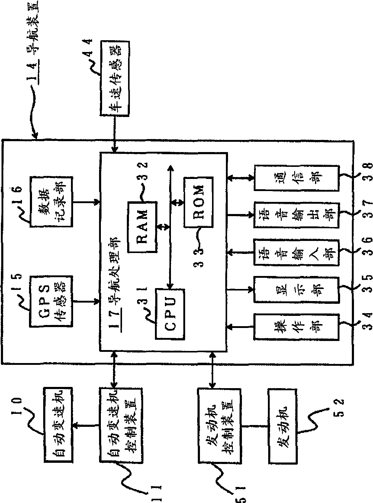
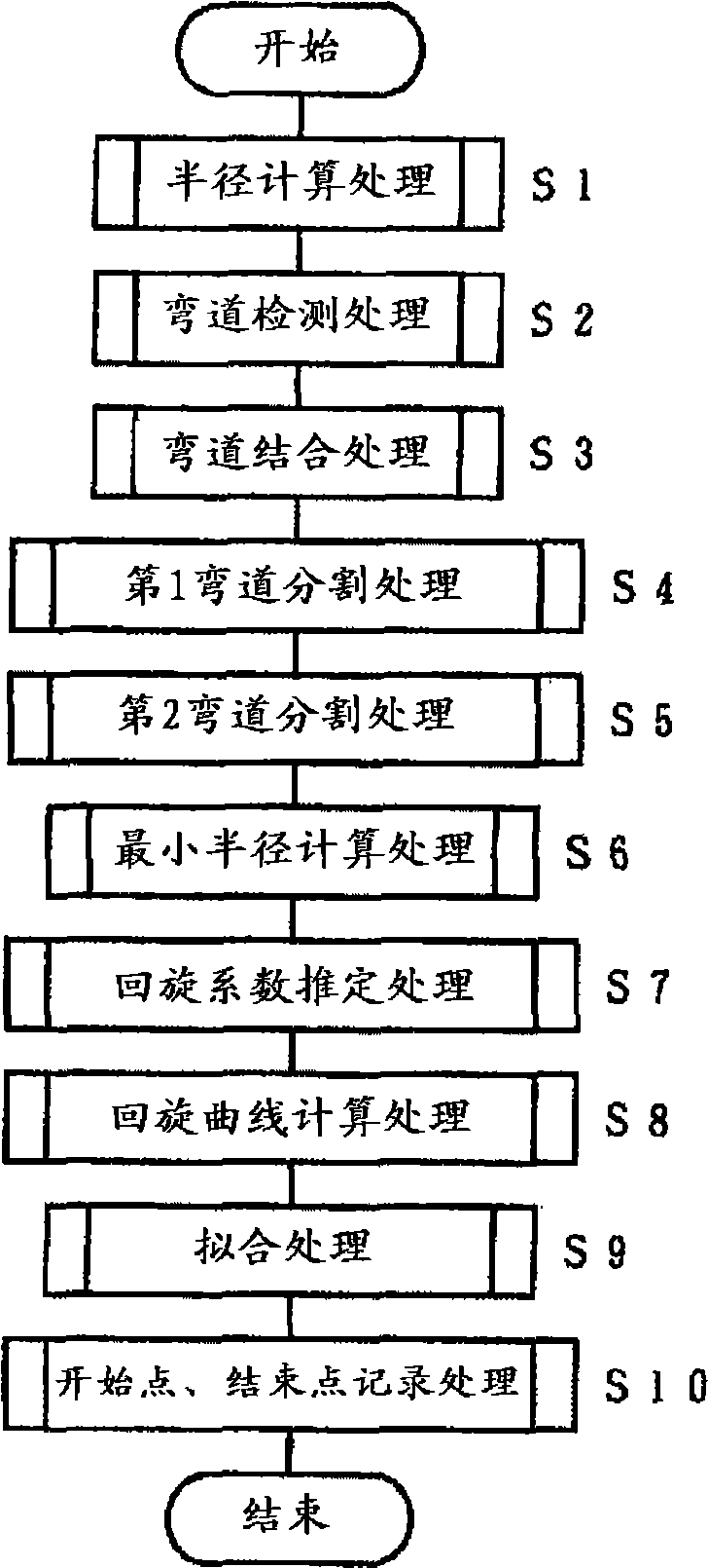
[0040] figure 1 It is a block diagram of the vehicle control system of embodiment of this invention. figure 2 is a main flowchart showing the operation of the road shape estimation processing device according to the embodiment of the present invention.

[0041] In the figure, 14 is an information terminal, for example, it is a navigation device as an on-vehicle device installed on a vehicle. A GPS sensor 15 as a current position detection unit; a data recording unit 16 as an information recording unit that records various information other than map data not shown in the figure; a navigation processing unit 17 that performs various calculation processing such as navigation processing ; the operation unit 34 used as the first input unit for predetermined input through the operation of the operator, that is, the driver; performs various displays through the im...


PUM


Abstract

The present invention provides a road shape estimating device, road shape estimating method and program, whic can accurately estimate the road shape. The road shape estimating device has a data obtaining processing unit for obtaining interpolation point data for a plurality of shape interpolation points which represent a shape of a road, a radius calculation processing unit for calculating a radius of curvature at each of shape interpolation points based on the interpolation point data, a corner detection processing unit detecting a corner based on the calculated radius of curvature, and a corner dividing processing unit for obtaining segment lengths of segments between respective shape interpolation points in the corner and dividing the corner by a segment length equal to or larger than a threshold which is set corresponding to an average value of the respective segment lengths. Since corner dividing is performed on segments wiht lengths larger than a threshold, the corner can be divided estimated appropriately.

Description

technical field [0001] The present invention relates to a road shape estimation device, a road shape estimation method, and a program. Background technique [0002] Conventionally, in a navigation device, for example, the current position of the vehicle is detected by GPS (Global Positioning System), that is, the current place, map data is read out from the data recording unit, and a map screen is formed on the display unit. The current location of the vehicle, a map of the surrounding area of ​​the vehicle, and the like are displayed on the display. Therefore, the driver can drive the vehicle according to the position of the own vehicle displayed on the above-mentioned map screen. [0003] Also, after the driver inputs a destination and sets search conditions, a route search process is performed based on the search conditions, and a route from a departure point displayed as a current location to a destination is searched according to the above-mentioned map data. Then, th...

Claims


Application Information

Patent Timeline
Patent Type & Authority Applications(China)
IPC IPC(8): G01C21/26G01C21/34G01C21/36G05D1/02
CPCG01C21/26
Inventor 福元将高杉浦博昭东条健到
Owner AISIN AW CO LTD
Learn More