Dynamic positioning and scheduling method and system based on GIS (Geographic Information System)

A dynamic positioning, dispatching and commanding technology, applied in the traffic control system of road vehicles, traffic control system, arrangement of variable traffic instructions, etc., can solve the problem of not considering the safety distance of multi-road sections and multi-vehicles

Inactive Publication Date: 2013-07-31
FUJIAN ZHONGGENG SHITONG INFORMATION TECH CO LTD
View PDF5 Cites 0 Cited by
  • Summary
  • Abstract
  • Description
  • Claims
  • Application Information

AI Technical Summary

Problems solved by technology

Although the existing car navigation system can provide intelligent navigation information for a single vehicle, and some even combine road traffic flow and traffic conditions to make real-time intelligent navigation, but for the dynamic positioning of fleets or even multiple fleets, especially in large-scale When it is necessary to command and dispatch multiple convoys during the event, the existing navigation system does not take into account factors such as multi-road sections, multiple convoys, and safety distances between convoys, so it has limitations in use

Method used


Image

  • Dynamic positioning and scheduling method and system based on GIS (Geographic Information System)
  • Dynamic positioning and scheduling method and system based on GIS (Geographic Information System)
  • Dynamic positioning and scheduling method and system based on GIS (Geographic Information System)

Examples


Embodiment Construction

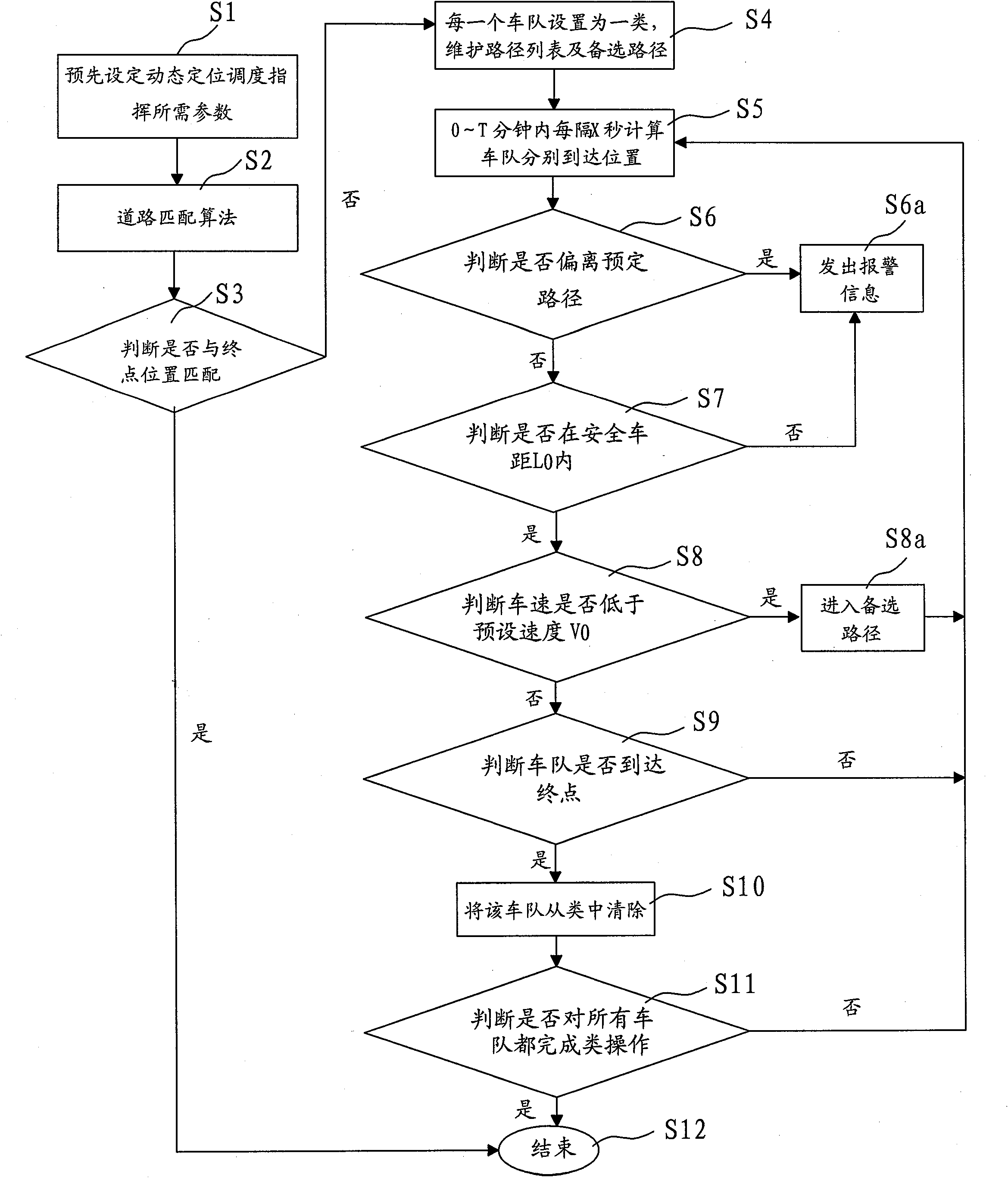
[0073] A preferred embodiment of the present invention will be further described below.

[0074] For a preferred embodiment of the GIS-based dynamic positioning, dispatching and commanding method of the present invention, a large-scale event police security team is taken as an example. reference figure 1 ,Specifically:

[0075] Step S1: Pre-set the parameters required for dynamic positioning and dispatching command, including starting and ending positions, fleet information, vehicle speed information, vehicle distance information and personnel information;

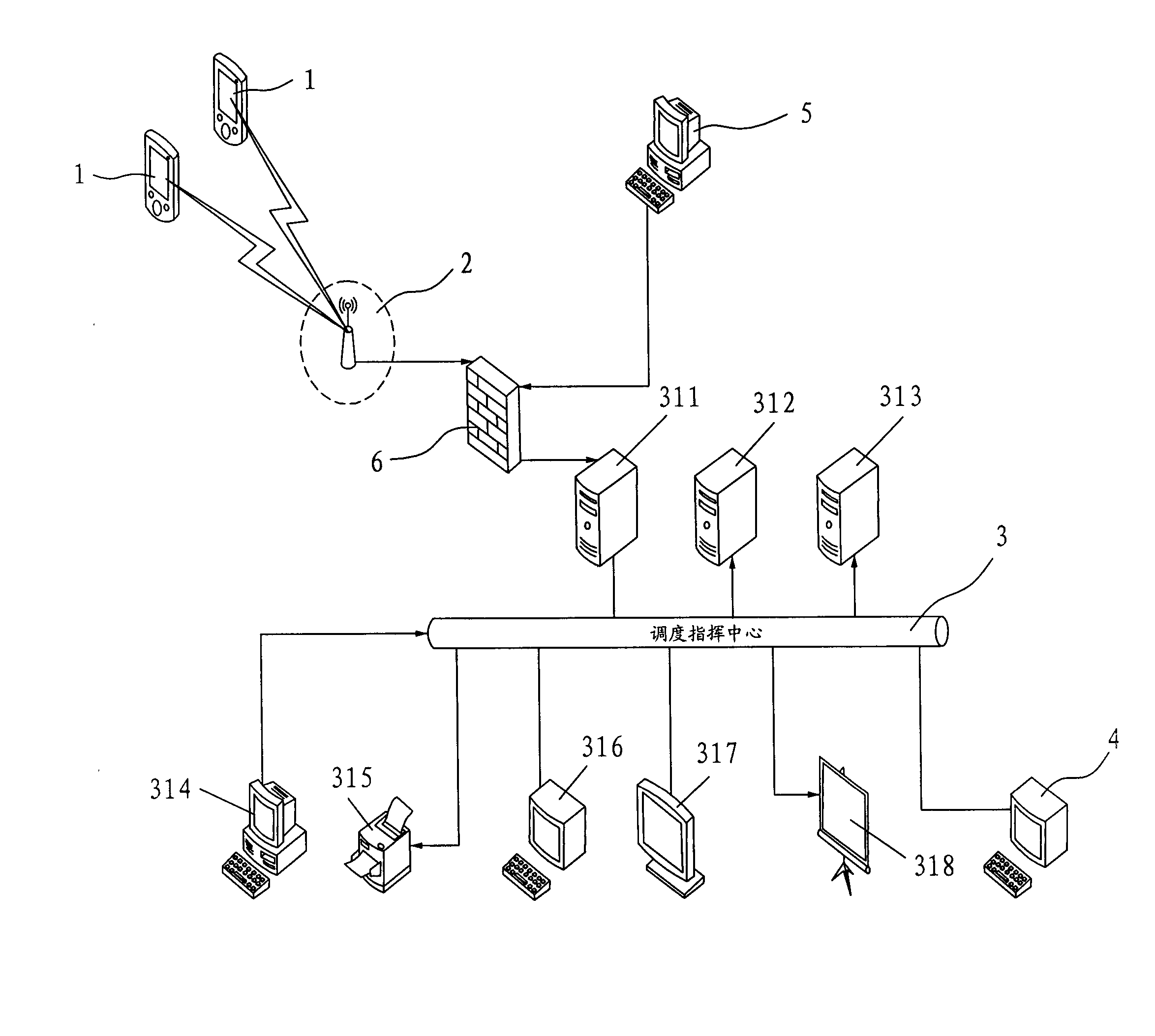
[0076] Step S2: Obtain GPS positioning information, and process the road matching algorithm according to the GIS geographic information system to calculate the geographic coordinate value of the current location;

[0077] Step S3: Judge whether the current position of the fleet matches the end position set in the GIS geographic information system, if so, no road matching algorithm processing is performed, and the process ends, ot...


PUM


Abstract

The invention relates to a dynamic positioning and scheduling method and system, which integrate satellite positioning, a digital map and a GIS (Geographic Information System) into a whole and are suitable for real time positioning and scheduling of fleets. The dynamic positioning and scheduling method comprises the following steps of: presetting a parameter required by dynamic positioning and scheduling; carrying out road matching algorithm processing according to GPS (Global Positioning System) positioning information and the GIS; setting each fleet as one category; calculating the positionwhere the fleet arrives every X seconds within 0-T min; judging whether the fleet deviates a preassigned path; judging whether other fleets are in a safety car distance value L0; if not, sending alarming information; judging whether the traveling average speed of the fleet is less than a set car speed value V0, if so, transferring to a standby path; judging whether the fleet arrives a destination, if so, clearing the fleet in the categories; repeating the steps until category operations of all fleets are completed. Therefore, by utilizing the dynamic positioning and scheduling method and system, the real time positioning and monitoring of a plurality of fleets can be realized, alarming can be given when conflict conditions occur, and intelligent command scheduling functions can be realized.

Description

Technical field [0001] The invention relates to the field of dynamic positioning, dispatching and commanding intelligent navigation based on a GIS geographic information system, in particular to a dynamic positioning, dispatching and commanding intelligent navigation method and system integrating GPS satellite positioning, digital map and GIS. Background technique [0002] GPS is the abbreviation of English Global Positioning System (Global Positioning System), and its Chinese abbreviation is "ball position system". GPS is a new generation of space satellite navigation and positioning system that was jointly developed by the United States Army, Navy and Air Force in the 1970s, and has the ability to navigate and locate in all directions in real time by sea, land and air. GPS system can be used not only for measurement and navigation, but also for speed and time measurement. Accurate positioning through the satellite signals received by GPS can know the driving route, location, s...

Claims


Application Information

Patent Timeline
Patent Type & Authority Patents(China)
IPC IPC(8): G08G1/00G08G1/09G08G1/123
Inventor 谢永强戴莎军
Owner FUJIAN ZHONGGENG SHITONG INFORMATION TECH CO LTD
Why Eureka
Try Eureka