Dynamic positioning and scheduling method and system based on GIS (Geographic Information System)
A dynamic positioning, dispatching and commanding technology, applied in the traffic control system of road vehicles, traffic control system, arrangement of variable traffic instructions, etc., can solve the problem of not considering the safety distance of multi-road sections and multi-vehicles
- Summary
- Abstract
- Description
- Claims
- Application Information
AI Technical Summary
Problems solved by technology
Method used
Image
Examples
Embodiment Construction
[0071] A preferred embodiment of the present invention will be further described below.
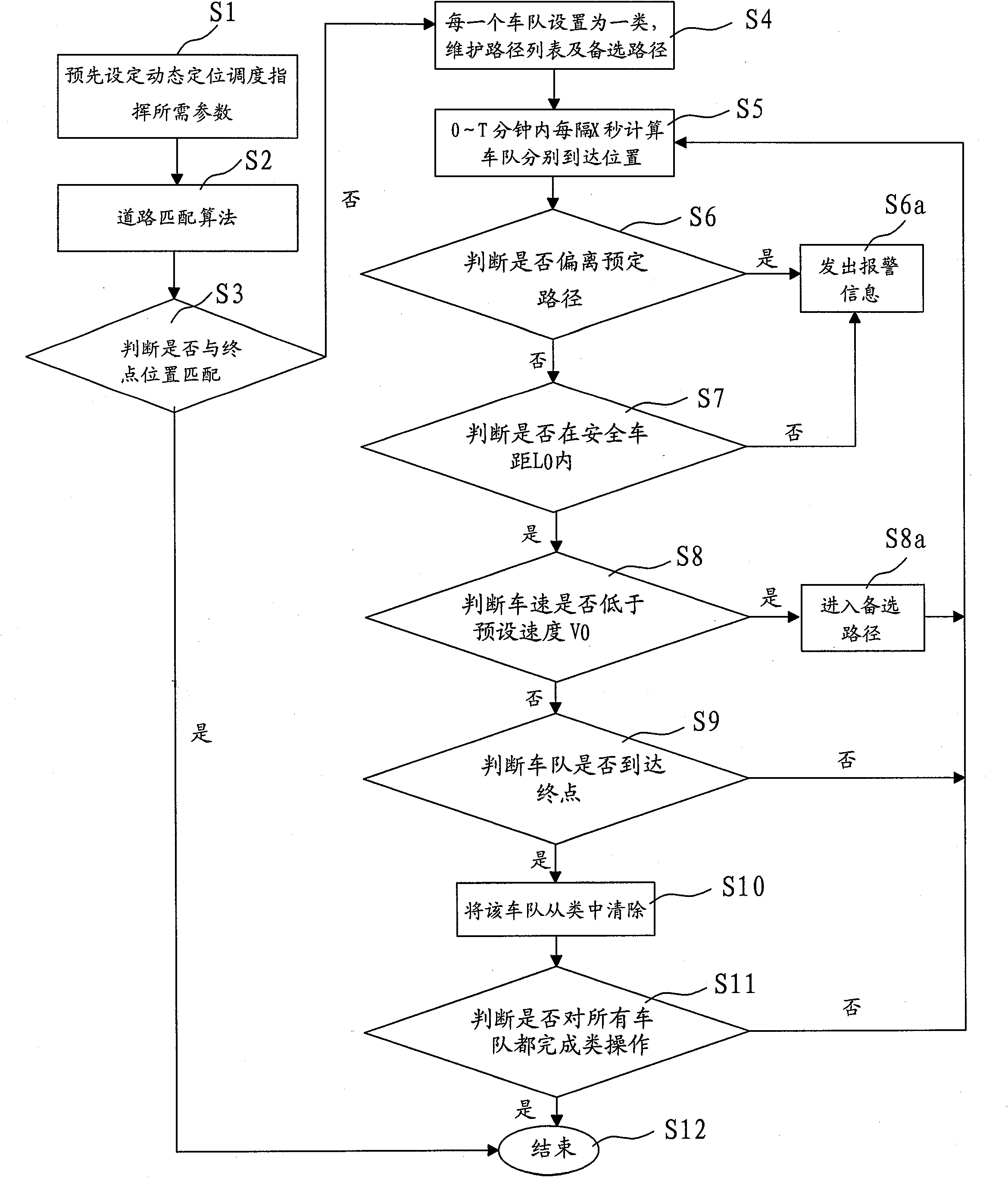
[0072] For a preferred embodiment of the GIS-based dynamic positioning dispatching command method of the present invention, the large-scale event police security fleet is used as an example for illustration. refer to figure 1 ,Specifically:
[0073] Step S1, pre-setting the parameters required for dynamic positioning dispatching and commanding, including start and end positions, fleet information, vehicle speed information, vehicle distance information and personnel information;
[0074] Step S2, obtaining GPS positioning information, and performing road matching algorithm processing according to the GIS geographic information system, and calculating the geographic coordinate value of the current position;
[0075] Step S3, judging whether the current position of the convoy matches the terminal position set in the GIS geographic information system, if yes, then no longer carry out the r...
PUM
 Abstract
Description
Claims
Application Information
 - R&D
- Intellectual Property
- Life Sciences
- Materials
- Tech Scout
- Unparalleled Data Quality
- Higher Quality Content
- 60% Fewer Hallucinations
Browse by: Latest US Patents, China's latest patents, Technical Efficacy Thesaurus, Application Domain, Technology Topic, Popular Technical Reports.
© 2025 PatSnap. All rights reserved.Legal|Privacy policy|Modern Slavery Act Transparency Statement|Sitemap|About US| Contact US: help@patsnap.com


