Extensive makeup language (XML)-based method for synchronously updating increment of spatial data

A technology of spatial data and update method, applied in the direction of electrical digital data processing, special data processing applications, instruments, etc., can solve problems such as error-prone, limited application fields, time-consuming and labor-intensive, etc., to avoid errors in data merging and ensure correctness and consistency, the effect of simple way to achieve

Active Publication Date: 2012-06-20
ZHEJIANG UNIV
View PDF2 Cites 11 Cited by
  • Summary
  • Abstract
  • Description
  • Claims
  • Application Information

AI Technical Summary

Problems solved by technology

[0005] Traditional spatial data synchronization solutions generally perform data synchronization updates in a networked environment, do not support offline environments, and have defects such as the granularity of synchronized spatial data objec

Method used


Image

  • Extensive makeup language (XML)-based method for synchronously updating increment of spatial data
  • Extensive makeup language (XML)-based method for synchronously updating increment of spatial data
  • Extensive makeup language (XML)-based method for synchronously updating increment of spatial data

Examples


Embodiment

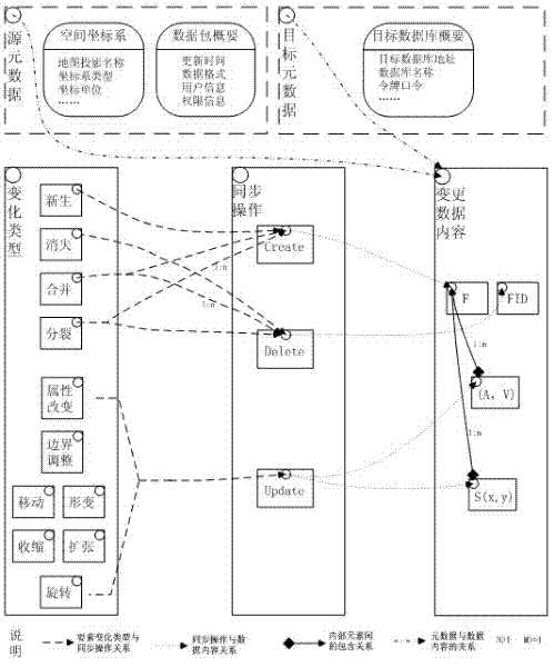
[0036]The spatial data incremental synchronous update method is applied in the spatial database, and its entire operation process is controlled by a C# class Services. The four major functional modules are implemented by four C# classes DataCollectionServices, DataOrganizationServices, ConflictIntercedeServices, and DataSynchronizationServices. Each function module class is called in the application program to realize the corresponding function and complete the whole running process. The specific steps are:

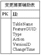
[0037] 1) Change the data collection function module DataCollectionServices to monitor the spatial data changes from the server, and record the changed information into the auxiliary spatial information change table;

[0038] 2) The change data organization function module DataOrganizationServices organizes the change data into XML data files to be exchanged according to the record information in the change summary auxiliary table, adding information such as synchronizati...


PUM


Abstract

The invention discloses an extensive makeup language (XML)-based method for synchronously updating increment of spatial data, which is used for establishing a spatial data bidirectional synchronous mechanism, realizing approximate consistency maintenance of multi-copy data, and solving the problems that: according to the common data synchronization method, offline environment is not supported, heterogeneous databases are not supported, and the synchronous object granularity and the synchronous process cannot be freely controlled and the like. Technologies such as NET, XML and the like are used as a basis of implementing the method for synchronously updating the spatial data. The system comprises a changed record collection module, a changed data organization module, a changed data conflict arbitration module and a changed data synchronization module, wherein the four functional modules have synergistic effects of monitoring, organizing and synchronizing the changed data to synchronously update the increment of the spatial data. According to the simple technical implementation method, the spatial data are effectively managed and automatically processed by computers, human-computer interaction is less, the time is saved, the work efficiency is improved, and the method has an extremely wide application prospect in the field of data consistency maintenance.

Description

technical field [0001] The invention belongs to the technical field of spatial data management. In particular, it relates to an XML-based incremental synchronous update method for spatial data. Background technique [0002] With the development and popularization of spatial databases, great achievements have been made in the construction of various spatial databases in my country, especially the multi-node spatial database model has been widely used in the basic geographic information platform systems of governments, enterprises and institutions. . In a multi-node spatial database system, how to ensure the consistency of the spatial data of each node is always a key issue in the basic geographic information platform. [0003] At present, ESRI, a well-known American GIS software manufacturer, provides a commercial solution based on Geodatabase replication technology, which can realize data replication and synchronization between two or more Geodatabases. Geodatabase Replica...

Claims


Application Information

Patent Timeline
IPC IPC(8): G06F17/30
Inventor 杜震洪刘仁义张丰常磊侯志通
Owner ZHEJIANG UNIV
Why Eureka
Try Eureka