Manufacturing method for projection digital elevation model capable of changing together with image

A digital elevation model, synchronous change technology, applied in image data processing, 3D modeling, instruments and other directions, can solve the problem of not eliminating the projection difference, not one-to-one correspondence, unable to obtain the real coordinates of the ground objects, etc.

Active Publication Date: 2012-06-20
WUHAN UNIV
View PDF2 Cites 16 Cited by
  • Summary
  • Abstract
  • Description
  • Claims
  • Application Information

AI Technical Summary

Problems solved by technology

The orthophoto in the current production process is generated by DEM as a model, so the points and elevations of the generated orthophoto are not in one-to-one correspondence except for a few bare ground. I...

Method used


Image

  • Manufacturing method for projection digital elevation model capable of changing together with image
  • Manufacturing method for projection digital elevation model capable of changing together with image
  • Manufacturing method for projection digital elevation model capable of changing together with image

Examples


specific Embodiment approach

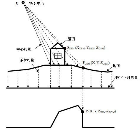
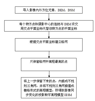
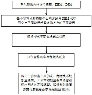
[0025] The invention provides a method for making a projection digital elevation model, which assigns elevations of corresponding positions to points on a digital image. see figure 1 , in the case of high-quality DSM and DEM data, the projection position of the roof of the house on the orthophoto can be accurately calculated. Such as figure 1 as shown, for the photography center, from the photography center Do a central projection. is a point on the DSM, assuming that its coordinates are . photography center with point The connection line constitutes the photographic light , light for photography The intersection point with the DTM surface, assuming its coordinates are . As shown in the figure below, the elevation changes of different points on the digital orthophoto, let the point The coordinates are: , calculate the corresponding points on all DSM Points, the projected digital elevation model that changes synchronously with the image can be obtain...


PUM


Abstract

The invention relates to a manufacturing method for a projection digital elevation model capable of changing together with an image, which combines internal-external orientation elements, DEM (Digital Elevation Model) data and DSM (Digital Surface Model) data of the image and generates the digital elevation model corresponding to the image. Through the invention, the positions of the points on the two-dimensional image are in one-to-one correspondence with three dimensional coordinates of the model, so as to accurately obtain real elevation value and horizontal coordinates of the corresponding points. Due to the adoption of the technical scheme provided by the invention, each image can obtain the corresponding surface coordinate and ground coordinate, thereby utilizing orthophoto image for image measuring rather than a stereoscopic image for observation.

Description

technical field [0001] The invention relates to a method for making a projection digital elevation model that changes synchronously with images. Background technique [0002] As we all know, we can use camera photography to record the three-dimensional real world in two-dimensional photos. Through photos, we can observe the world from a two-dimensional perspective, but how to know the elevation of the object recorded in the photo from a single photo? What about information? If we can directly obtain the elevation information of the corresponding objects from the photos, it will greatly promote the speed and efficiency of obtaining digital line drawings and orthophotos in the field of surveying and mapping. This is not possible with existing technology. [0003] From the early 1990s to the present, airborne lidar has gone through nearly 20 years. Most of the lidar systems today are equipped with a camera to record the image information in the survey map, which is used for t...

Claims


Application Information

Patent Timeline
IPC IPC(8): G06T17/05
Inventor 张祖勋胡翔云朱俊锋孙明伟
Owner WUHAN UNIV
Why Eureka
Try Eureka