Remote sensing coal searching method based on China-Brazil satellite

A remote sensing and satellite technology, applied in the field of mineral exploration, to achieve accurate exploration results, improve cognition, and eliminate differences in light reflection

Active Publication Date: 2012-06-27
CHINA SHENHUA ENERGY CO LTD +1
View PDF5 Cites 3 Cited by
  • Summary
  • Abstract
  • Description
  • Claims
  • Application Information

AI Technical Summary

Problems solved by technology

However, there is no solution in the prior art for how to determine whether there is coal in an area where geological data is unknown

Method used


Image

  • Remote sensing coal searching method based on China-Brazil satellite
  • Remote sensing coal searching method based on China-Brazil satellite
  • Remote sensing coal searching method based on China-Brazil satellite

Examples


Embodiment Construction

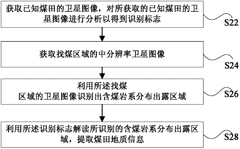
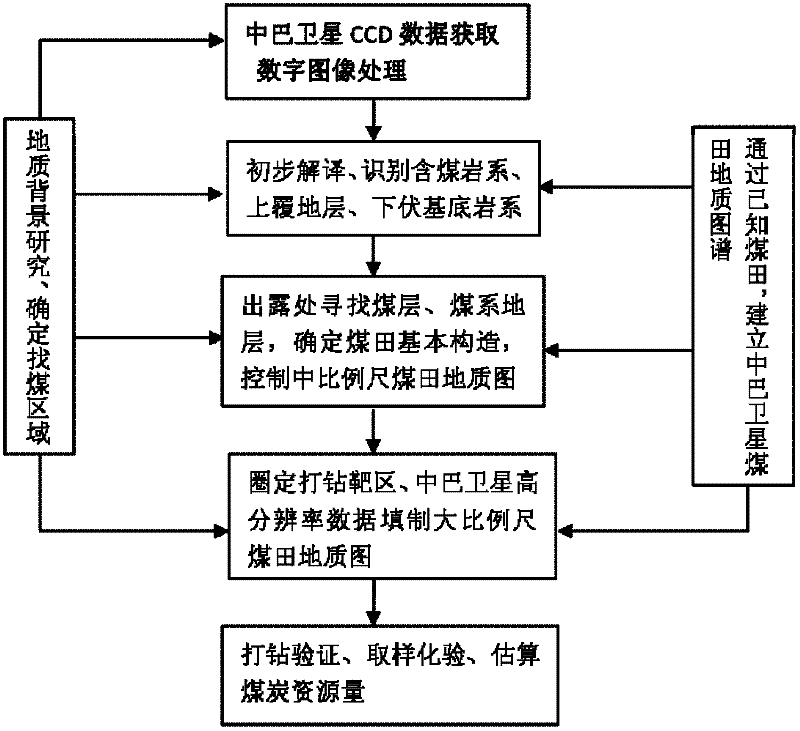
[0016] Hereinafter, the principles of the present invention will be described in conjunction with preferred embodiments of the present invention with reference to the accompanying drawings. It should be noted that, in the field of satellite remote sensing, the medium resolution is 10-30m; the high resolution is less than 10m; the medium scale is at least one of the following: 1:100,000, 1:200,000 and 1:250,000; and said large scale is at least one of the following: 1:10,000, 1:25,000 and 1:50,000.

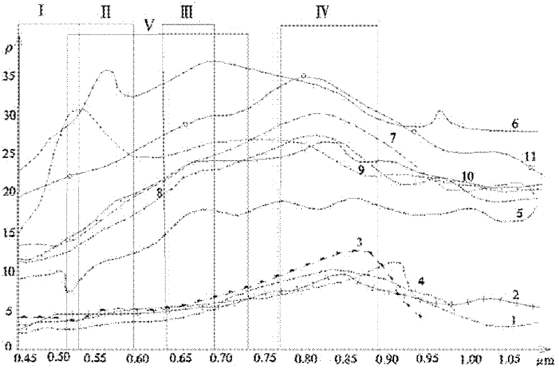
[0017] The principle of using satellite images to identify exposed or semi-exposed coal fields on the ground is that in the light field, coal seams have the lowest reflectance compared with other rocks (mainly sandstone and glutenite that divide stratigraphic units). Generally, the reflectance of coal seam is 4-12%, while that of sandstone and glutenite is 8-35%. Based on this principle, the color tone of the rock, that is, "gray scale", can directly reflect the reflectivity. The...


PUM


Abstract

The invention discloses a remote sensing coal searching method based on a satellite and can be applied to a China-Brazil satellite. The method comprises the following steps of: acquiring a satellite image of a known coal field, and analyzing the satellite image of the known coal field to obtain an identification mark; acquiring a satellite image of a coal searching area; identifying a coal-bearing formation distribution exposed area through the satellite image of the coal searching area; and analyzing the identified coal-bearing formation distribution exposed area through the identification mark, and extracting the geological information of the coal field. By the method, a novel coal field at a position with unknown geological information can be found. By the method, the unknown coal field can be remotely sensed, and field tests prove that: the novel coal field is found, the prospecting efficiency is greatly improved, the cost is reduced, and a prospecting period is shortened.

Description

technical field [0001] The invention relates to the field of mineral exploration, in particular to a satellite-based remote sensing coal prospecting method. Background technique [0002] With the development of satellite technology, methods of prospecting coal resources using satellite images have emerged. [0003] The prior art provides a method for coal prospecting by satellite remote sensing. In this method, firstly, field geological basic work is carried out on the target area, and data such as geology, geophysical prospecting, and drilling are obtained. Then, the target area is remotely sensed by satellite, and the medium-scale remote sensing geological map is compiled by using the obtained medium-resolution satellite image, and the geological, geophysical prospecting, drilling and other data in the range shown in the image are comprehensively analyzed and studied to find coal-bearing lot. [0004] Through the above-mentioned method in the prior art, it is possible to...

Claims


Application Information

Patent Timeline
Patent Type & Authority Applications(China)
IPC IPC(8): G01V8/10
Inventor 管海晏于涛孟淑英吴查查郭晓波卢琳
Owner CHINA SHENHUA ENERGY CO LTD
Why Eureka
Try Eureka