Temporally based weather symbology

A technology of weather and time, applied to instruments, navigation, traffic control systems, etc., can solve problems such as increasing crew workload

Active Publication Date: 2012-09-19
THE BOEING CO
View PDF8 Cites 12 Cited by
  • Summary
  • Abstract
  • Description
  • Claims
  • Application Information

AI Technical Summary

Problems solved by technology

These mental calculations can increase crew workload, especially during critical phases of flight, s...

Method used


Image

  • Temporally based weather symbology
  • Temporally based weather symbology
  • Temporally based weather symbology

Examples


Embodiment Construction

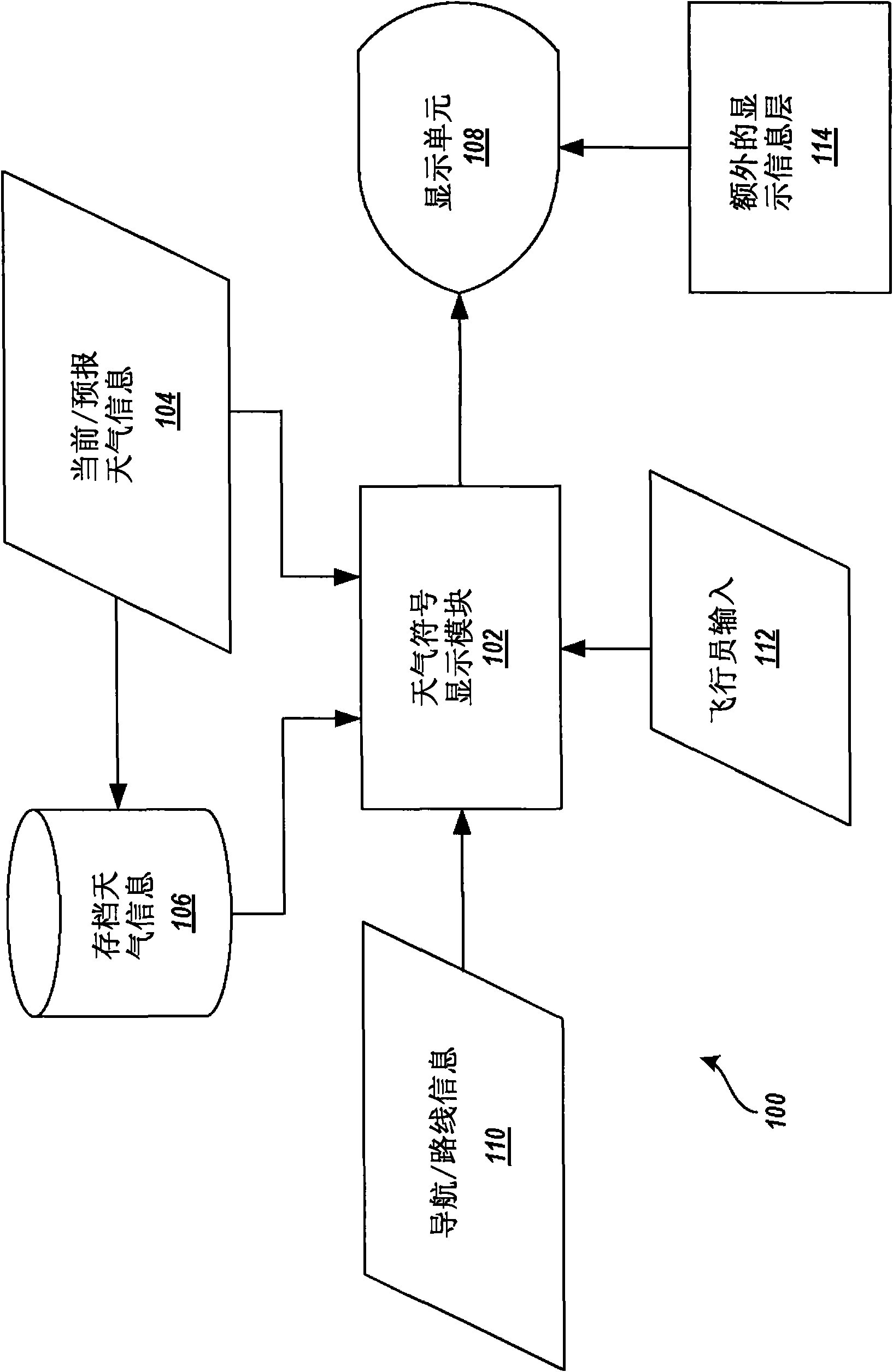
[0014] The following detailed description is directed to methods, systems, and computer-readable media for integrating geo-spatial-available and time-encoded textual weather information into graphical map displays. Utilizing the concepts and techniques described herein, current and forecast textual weather information received at the aircraft is received, parsed, and plotted in the graphical map display within the temporal context of the graphical map display using symbols that visually show the current Weather conditions and past and future trends. Automatically parsing geospatially available textual weather information and displaying the information graphically on a map improves aircraft crew awareness of weather conditions while reducing their workload and reducing errors in interpreting information. These and other advantages and features will become apparent from the description of the various embodiments that follow.

[0015] In the following detailed description, refer...


PUM


Abstract

Methods, systems, and computer-readable media are described herein for integrating geo-spatially enabled and time-encoded textual weather information into a graphical map display. Time-encoded textual weather information regarding one or more geographic locations is received, parsed, and interpreted in light of a temporal context of the graphical map display. Weather symbology relating the weather conditions within the temporal context of the graphical map display is generated from the parsed textual weather information and displayed at positions on the map corresponding to the geographic locations. The weather symbology may include weather pictograms that relate past, current, and future weather conditions at the corresponding geographic locations according to the temporal context of the graphical map display.

Description

technical field [0001] The present invention relates to methods and systems for integrating weather information into graphical map displays. Background technique [0002] For flight crews, weather conditions are a critical part of the situation that needs to be informed. Some weather hazards, such as reduced visibility, elevated winds, turbulence, precipitation, increased icing potential, convective weather, and similar conditions may affect aircraft performance and passenger comfort and safety. Conventionally, flight crews receive current and forecast weather information prior to a flight including origin, destination, and alternate airports, and along airport routes. The weather information may be in the form of a printout including text information as well as a 2-D weather map. However, especially when flying over long distances, this information may become outdated, which reduces the effectiveness of pre-flight weather information in keeping the weather informed. [0...

Claims


Application Information

Patent Timeline
IPC IPC(8): G06F19/00
CPCG01W1/00G09B29/006G08G5/0021G09B29/10G08G5/0013G01C23/00G08G5/0091
Inventor T·汉克斯T·维斯曼
Owner THE BOEING CO
Why Eureka
Try Eureka