Method for automatically identifying sea-surface oil spill in aviation hyperspectral remote sensing mode based on spectral characteristic difference of oil and water

A technology of hyperspectral remote sensing and spectral features, which is applied in the field of automatic identification of sea surface oil spills by aerial hyperspectral remote sensing, and can solve the problems of few remote sensing monitoring methods for sea surface oil spills, and mature automatic monitoring methods have not yet been formed.

Active Publication Date: 2015-04-08
SECOND INST OF OCEANOGRAPHY MNR
View PDF5 Cites 0 Cited by
  • Summary
  • Abstract
  • Description
  • Claims
  • Application Information

AI Technical Summary

Problems solved by technology

[0014] There are currently few remote sensing monitoring methods for sea surface oil spills based on differences in spectral characteristics, and a mature automatic monitoring method has not yet been formed.

Method used


Image

  • Method for automatically identifying sea-surface oil spill in aviation hyperspectral remote sensing mode based on spectral characteristic difference of oil and water
  • Method for automatically identifying sea-surface oil spill in aviation hyperspectral remote sensing mode based on spectral characteristic difference of oil and water
  • Method for automatically identifying sea-surface oil spill in aviation hyperspectral remote sensing mode based on spectral characteristic difference of oil and water

Examples


Embodiment Construction

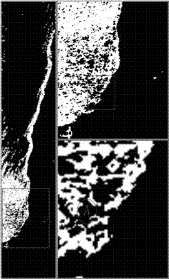
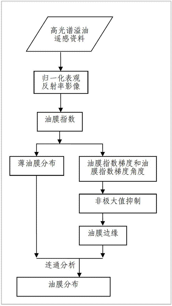
[0070] The method flow chart of the automatic identification of sea surface oil spill based on the difference of oil and water spectral features by aerial hyperspectral remote sensing is shown in the appendix figure 1 ,Proceed as follows:

[0071] 1) Calculate the normalized apparent reflectance for each pixel of the aerial hyperspectral remote sensing image to form an aerial hyperspectral normalized apparent reflectance image;

[0072] 2) Calculate the oil film index for each pixel of the aerial hyperspectral normalized apparent reflectance image to form an aerial hyperspectral oil film index image;

[0073] 3) Construct aerial hyperspectral oil film index gradient images and aerial hyperspectral oil film index gradient angle images based on aerial hyperspectral oil film index images;

[0074] 4) Based on the aerial hyperspectral oil film index gradient image and oil film index gradient angle image, non-maximum suppression is performed on the edge gradient value to form the ...


PUM


Abstract

The invention discloses a method for automatically identifying sea-surface oil spill in an aviation hyperspectral remote sensing mode based on the spectral characteristic difference of oil and water. The method comprises the following steps of: 1) calculating the normalization apparent reflectance of each image element of an aviation hyperspectral remote sensing image; 2) calculating oil film indexes of each image element of a normalization apparent reflectance image; 3) constructing an oil film index gradient image and an oil film index gradient angle image on the basis of an oil film index image; 4) performing non-maxima suppression on an edge gradient value; 5) forming an oil film edge image by using the oil film index gradient image which is subjected to the non-maxima suppression; 6) identifying a thin oil film of each image element of the oil film index image to form a thin oil film distribution image; and 7) extracting a sea-surface oil spill total-distribution remote sensing image on the basis of the oil film edge image and the thin oil film distribution image. By adoption of the method, the sea-surface oil spill can be automatically identified in the aviation hyperspectral remote sensing mode. The method can be used for guiding the clean-up evaluation of sea oil spill and plays an important role in sea environment protection.

Description

technical field [0001] The invention relates to the technical field of remote sensing, in particular to a method for automatically identifying sea surface oil spills by aerial hyperspectral remote sensing based on differences in spectral characteristics of oil and water. Background technique [0002] With the rapid advancement of the global industrialization process, the demand for oil in human society is increasing day by day, the scale of its exploitation is expanding rapidly, the number of offshore oil wells and the volume of offshore oil transportation are increasing sharply. Sea oil spill incidents caused by offshore operations, transportation and equipment are also increasing, which aggravates marine oil pollution, which in turn endangers the living environment of marine organisms and seriously threatens the marine ecological environment and fishery resources. Compared with ship surveys, the use of remote sensing to monitor oil spill information has the advantages of r...

Claims


Application Information

Patent Timeline
Patent Type & Authority Patents(China)
IPC IPC(8): G06K9/00
Inventor 王迪峰潘德炉詹远增毛志华龚芳王天愚
Owner SECOND INST OF OCEANOGRAPHY MNR
Why Eureka
Try Eureka