Multi-pass circumference SAR three-dimensional imaging method

A three-dimensional imaging, circular technology, applied in the direction of reflection/re-radiation of radio waves, use of re-radiation, measurement devices, etc., can solve the problems of decreased three-dimensional resolution, unable to maintain correlation of scene scattering points, high image side lobes, etc.

Active Publication Date: 2013-02-06
UNIV OF ELECTRONICS SCI & TECH OF CHINA
View PDF3 Cites 16 Cited by
  • Summary
  • Abstract
  • Description
  • Claims
  • Application Information

AI Technical Summary

Problems solved by technology

[0005] The purpose of the present invention is to solve the problem that the scene scattering points in the existing circular SAR cannot maintain correlation within the 360-degree observation angle, resulting in a decrease in three-dimensional resolution, and the method of divi

Method used


Image

  • Multi-pass circumference SAR three-dimensional imaging method
  • Multi-pass circumference SAR three-dimensional imaging method
  • Multi-pass circumference SAR three-dimensional imaging method

Examples


Embodiment Construction

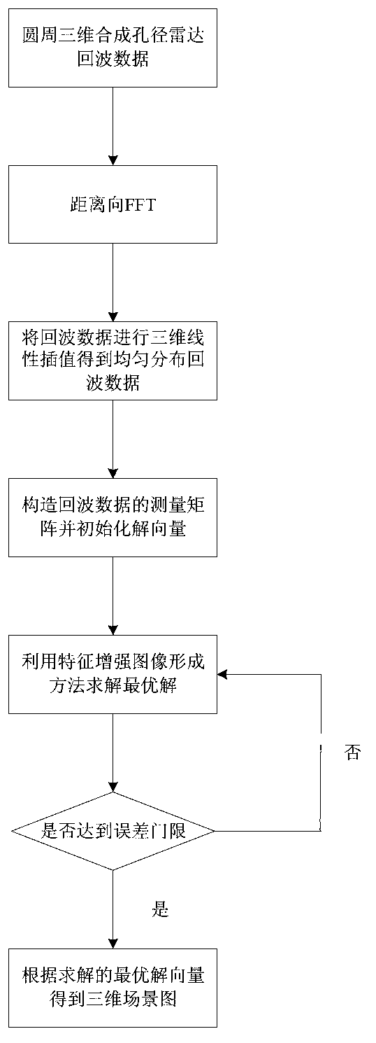
[0106] The present invention mainly adopts the mode of simulation experiment to verify the feasibility of the system model, and all steps and conclusions are verified correctly on MATLAB7.0. The specific implementation steps are as follows:

[0107] Step 1: System parameter setting and initialization of the parameters of the feature image enhancement method

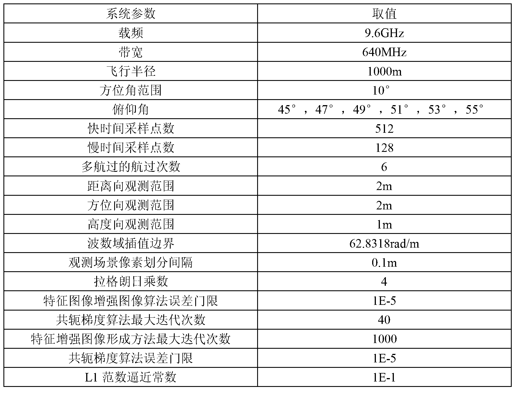
[0108] The system parameters adopted in this specific implementation mode are detailed in image 3 .

[0109] Step 2. Construct the motion model of multi-travel three-dimensional synthetic aperture radar

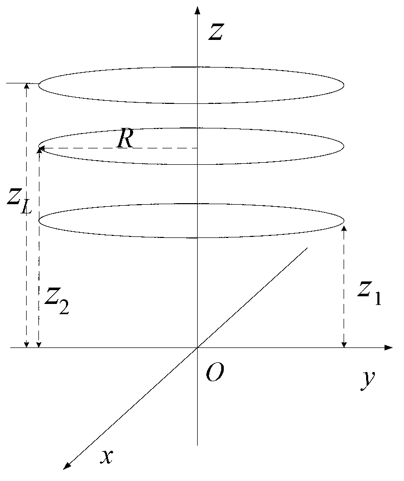
[0110] Take the center point O of the scene as the origin, the ground as the xy plane, and the height as the z-axis to construct a spatial rectangular coordinate system. The radar motion platform is based on [0,0,z 1 ],[0,0,z 2 ]...[0,0,z 6 ] as the center of the circle to do a circular motion with a radius of R = 1000m, where z 1 =1414m,z 2 =1466m,z 3 =1524m,z 4 =1589m,z 5 =1662m,z 6 =1743m.

[0111] Step 3...


PUM


Abstract

The invention discloses a multi-pass circumference SAR three-dimensional imaging method. The method comprises the following steps of: carrying out distance compression processing on distance data; carrying out fast one-dimensional Fourier transform (FFT) so as to convert the data into a wave number domain; carrying out a three-dimensional linear interpolation to obtain a uniformly distributed data format under a right-angle coordinate system; constructing a linear observing model of a radar echo signal in the wave number domain; constructing an optimized target function by using a weighted L1 norm; and solving an optimized solution vector by using an iterative algorithm in a characteristic enhanced image forming method. Therefore, a three-dimensional imaging result of a target scene is obtained, the three-dimensional imaging is realized, a side band is effectively reduced, the resolution rate is improved, and a good image focusing effect is realized.

Description

technical field [0001] The invention belongs to the technical field of radar imaging, and in particular relates to the technical field of synthetic aperture radar (SAR) imaging. Background technique [0002] Synthetic Aperture Radar (SAR) is a microwave imaging system with all-weather and all-weather working capabilities. It can obtain excellent imaging results in harsh environments, so its position in civilian and military applications is irreplaceable. , is an effective means for topographic mapping and military reconnaissance applications. It uses the movement of the radar platform along the track to form a virtual antenna array synthetic aperture to obtain the resolution of the track, and uses pulse compression technology to obtain the resolution of the oblique range. [0003] Three-dimensional synthetic aperture radar (SAR) is a new type of synthetic aperture radar technology. The basic principle of the three-dimensional synthetic aperture radar imaging system is to o...

Claims


Application Information

Patent Timeline
IPC IPC(8): G01S13/90G01S7/41
CPCG01S13/9011G01S13/9088
Inventor 张晓玲田甲申
Owner UNIV OF ELECTRONICS SCI & TECH OF CHINA
Why Eureka
Try Eureka