Method and system for generating equal-scale real-scene scene map by using aerial images

An aerial image and equal-scale technology, which is applied in the field of traffic accident scene information acquisition, can solve the problems of long measurement and drawing time, easy omission of key parameters, and low efficiency, and achieve short measurement and drawing time, which is conducive to rapid recovery and avoids measurement errors. Effect

Inactive Publication Date: 2015-11-25
THE THIRD AFFILIATED HOSPITAL OF THIRD MILITARY MEDICAL UNIV OF PLA
View PDF2 Cites 0 Cited by
  • Summary
  • Abstract
  • Description
  • Claims
  • Application Information

AI Technical Summary

Problems solved by technology

In the shooting of the traffic accident scene, the camera is usually used for shooting, and each photo taken can only reflect the accident situation in one direction. To restore the accident scene, it is necessary to use the on-site measurement results to manually draw a schematic diagram on the coordinate paper. At present, the measurement of the accident scene is mainly carried out manually, so the manual drawing of the schematic diagram has the following limitations: (1) the efficiency is extremely low, and the measurement and drawing time is long, which is not conducive to the rapid recovery of the traffic accident scene; (2) the accuracy of manual measurement is low, Moreover, manual drawing standards are different, and it is difficult to grasp the proportions of vehicles, roads, and traces; (3) some key parameters are easy to miss and cannot be made up; (4) it is impossible to perform secondary verification on the accident scene
In some disputed accidents, if there is doubt about some of the measured dimensions or there is a contradiction between the measured dimensions, the secondary verification cannot be carried out

Method used


Image

  • Method and system for generating equal-scale real-scene scene map by using aerial images
  • Method and system for generating equal-scale real-scene scene map by using aerial images
  • Method and system for generating equal-scale real-scene scene map by using aerial images

Examples


Embodiment Construction

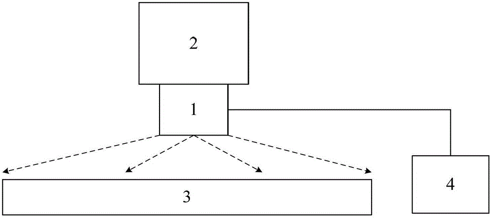
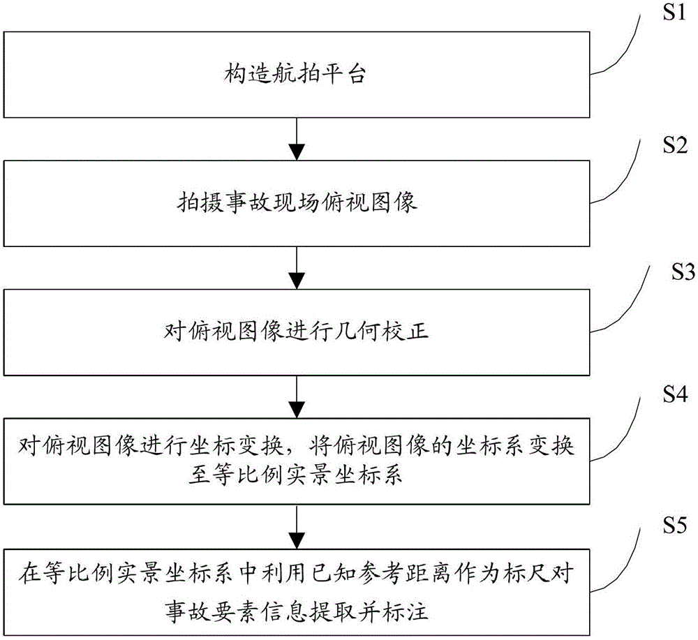
[0037] Embodiments of the present invention are described in detail below, examples of which are shown in the drawings, wherein the same or similar reference numerals designate the same or similar elements or elements having the same or similar functions throughout. The embodiments described below by referring to the figures are exemplary only for explaining the present invention and should not be construed as limiting the present invention.

[0038] In the description of the present invention, unless otherwise specified and limited, it should be noted that the terms "installation", "connection" and "connection" should be understood in a broad sense, for example, it can be mechanical connection or electrical connection, or two The internal communication of each element may be directly connected or indirectly connected through an intermediary. Those skilled in the art can understand the specific meanings of the above terms according to specific situations.

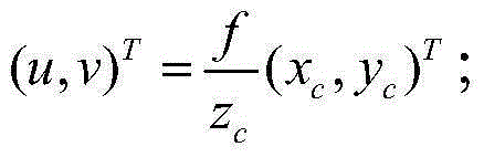
[0039] The inventio...


PUM


Abstract

The invention provides a method and a system for generating equal proportion live field map with aerial images. The method comprises the following steps of: building an aerial photography platform; photographing a vertical view of the site of accident; executing geometric correction on the vertical view; performing transformation of coordinates for the vertical view, and transforming the coordinate system of the vertical view into an equal proportion live coordinate system; and extracting and marking accident essential factor information. With the method and the system, a true and fine two-dimensional equal proportion live field map can be obtained through geometric correction and transformation of coordinates for the aerial images, and each essential factor of the site of accident is restored efficiently and accurately.

Description

technical field [0001] The invention relates to the technical field of traffic accident scene information acquisition, in particular to a method and system for generating an equal-scale real-scene scene map by using aerial images. Background technique [0002] Accident site investigation and site map drawing are the first link in road traffic accident handling. The main tasks include the measurement and equal-scale drawing of various elements on the site, and taking pictures of the site, etc. In the shooting of the traffic accident scene, the camera is usually used for shooting, and each photo taken can only reflect the accident situation in one direction. To restore the accident scene, it is necessary to use the on-site measurement results to manually draw a schematic diagram on the coordinate paper. At present, the measurement of the accident scene is mainly carried out manually, so the manual drawing of the schematic diagram has the following limitations: (1) the efficie...

Claims


Application Information

Patent Timeline
Patent Type & Authority Patents(China)
IPC IPC(8): G06T5/00G06T7/00
Inventor 尹志勇苏森明健雄刘文君杨光瑜赵辉
Owner THE THIRD AFFILIATED HOSPITAL OF THIRD MILITARY MEDICAL UNIV OF PLA
Why Eureka
Try Eureka