
Automatic semantic labeling method of high resolution remote sensing image

A remote sensing image, high-resolution technology, applied in the field of remote sensing image processing, can solve the problems of not conforming to the remote sensing image, the remote sensing image is large in size, cannot reflect the target concept of interest, etc. Effect

Active Publication Date: 2013-07-10
济钢防务技术有限公司
View PDF5 Cites 35 Cited by
  • Summary
  • Abstract
  • Description
  • Claims
  • Application Information

AI Technical Summary

Problems solved by technology

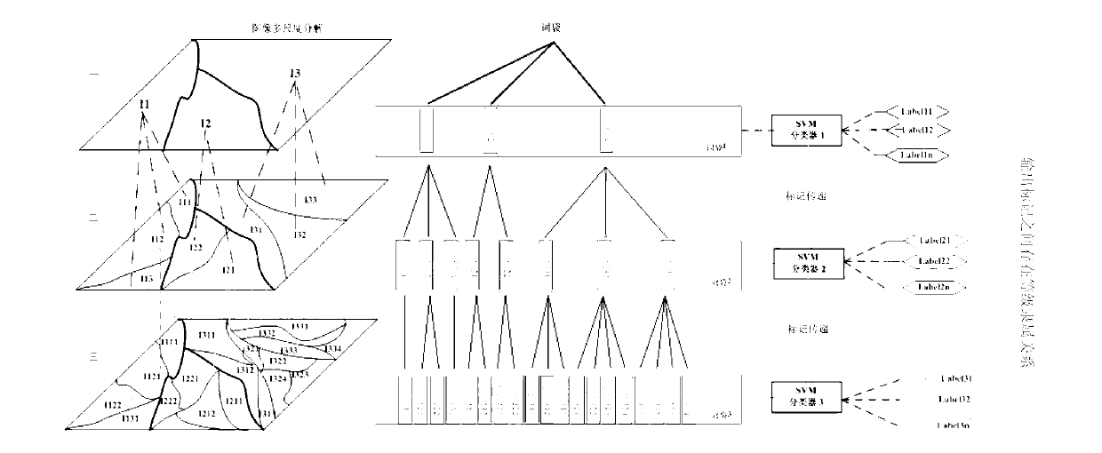
[0004] However, the traditional multi-instance-multi-label learning method ignores the semantic correlation between examples in the bag of words, and often uses a method of uniformly segmenting images when constructing examples, resulting in a balanced multi-instance-multi-label learning method for image annotation. Treating every example, it is impossible to truly realize the semantic layer annotation of images from the perspective of image targets
This way of dealing with the problem is obviously not in line with the characteristics of remote sensing images: the size of remote sensing images is generally large, reflecting the features and landforms in a large area, while remote sensing images are usually only interesting to users during the interpretation process of remote sensing images. Some of the local areas, therefore, directly extracting the global features of the entire image cannot reflect the target concept of interest, so it is necessary to decompose or segment the entire image

Method used


Image

  • Automatic semantic labeling method of high resolution remote sensing image
  • Automatic semantic labeling method of high resolution remote sensing image
  • Automatic semantic labeling method of high resolution remote sensing image

Examples


Embodiment Construction

[0028] In order to make the object, technical solution and advantages of the present invention clearer, the present invention will be described in further detail below in conjunction with specific embodiments and with reference to the accompanying drawings.

[0029] It should be noted that, in the drawings or descriptions of the specification, similar or identical parts all use the same figure numbers. And in the drawings, the embodiments are marked for simplification or convenience. Furthermore, implementations not shown or described in the accompanying drawings are forms known to those of ordinary skill in the art. Additionally, while illustrations of parameters including particular values ​​may be provided herein, it should be understood that the parameters need not be exactly equal to the corresponding values, but rather may approximate the corresponding values ​​within acceptable error margins or design constraints.

[0030] In the automatic labeling method for high-reso...


PUM


Abstract

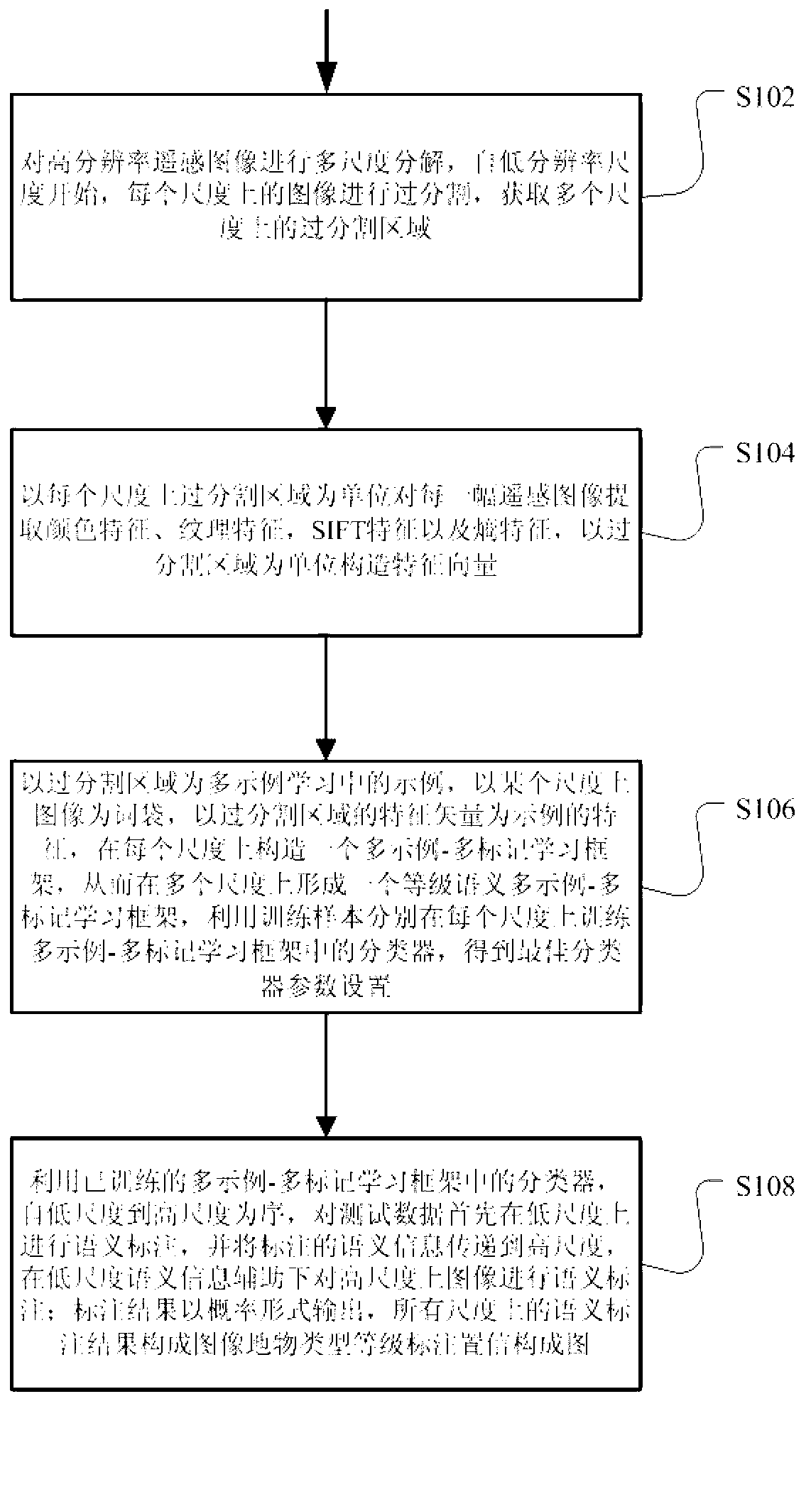
The invention discloses an automatic semantic labeling method of a high resolution remote sensing image. In the automatic semantic labeling of the high resolution remote sensing image, the automatic semantic labeling method carries out modeling on multi-scale semantic information of the remote sensing image by using a level semantic model, and achieves the automatic labeling of the high resolution remote sensing image by combining a multi-instance learning method. The automatic semantic labeling method of the high resolution remote sensing image is characterized in that the level semantic model is used for achieving a modeling expression of the prior membership function of surface features; a multi-instance multi-label method is introduced to the semantic labeling of the remote sensing image, and the difficulty of labeling work is reduced; the output results of image labeling are provided in the type of the surface feature grade membership function, and the probability confidence coefficient of the labeling results is automatically provided.

Description

technical field [0001] The invention relates to the field of remote sensing image processing, in particular to a method for semantic labeling or semantic classification of high-resolution remote sensing images. Background technique [0002] Automatic semantic annotation of remote sensing images is the basis of remote sensing image organization and indexing. Especially with the explosive increase of remote sensing data in recent years, the amount of high-resolution remote sensing image data is huge, and it is more difficult to directly search and acquire images. High-resolution remote sensing images The meaning of semantic annotation is more obvious. However, the existing manual direct labeling is time-consuming, laborious, and not feasible, and an efficient labeling method from the image semantic level is urgently needed. In the prior art, there are mainly methods for semantic labeling of high-resolution remote sensing images: multi-instance multi-label learning (Multi-inst...

Claims


Application Information

Patent Timeline
IPC IPC(8): G06K9/66G06T7/00
Inventor 陈克明鉴萍郭建恩周志鑫张道兵孙显
Owner 济钢防务技术有限公司
Learn More