A Martian dem production and aeronautical triangulation method

An aerial triangulation and Mars technology, applied in the field of deep space surveying and mapping, can solve problems such as low encryption accuracy and strong dependence on initial values

Active Publication Date: 2015-10-28
NANJING UNIV OF AERONAUTICS & ASTRONAUTICS
View PDF4 Cites 0 Cited by
  • Summary
  • Abstract
  • Description
  • Claims
  • Application Information

AI Technical Summary

Problems solved by technology

Traditional aerial triangulation uses Euler angles to represent the rotation and translation of coordinates, and the processing of images with large inclination angles often has low encryption accuracy and strong dependence on initial values

Method used


Image

  • A Martian dem production and aeronautical triangulation method
  • A Martian dem production and aeronautical triangulation method
  • A Martian dem production and aeronautical triangulation method

Examples


Embodiment Construction

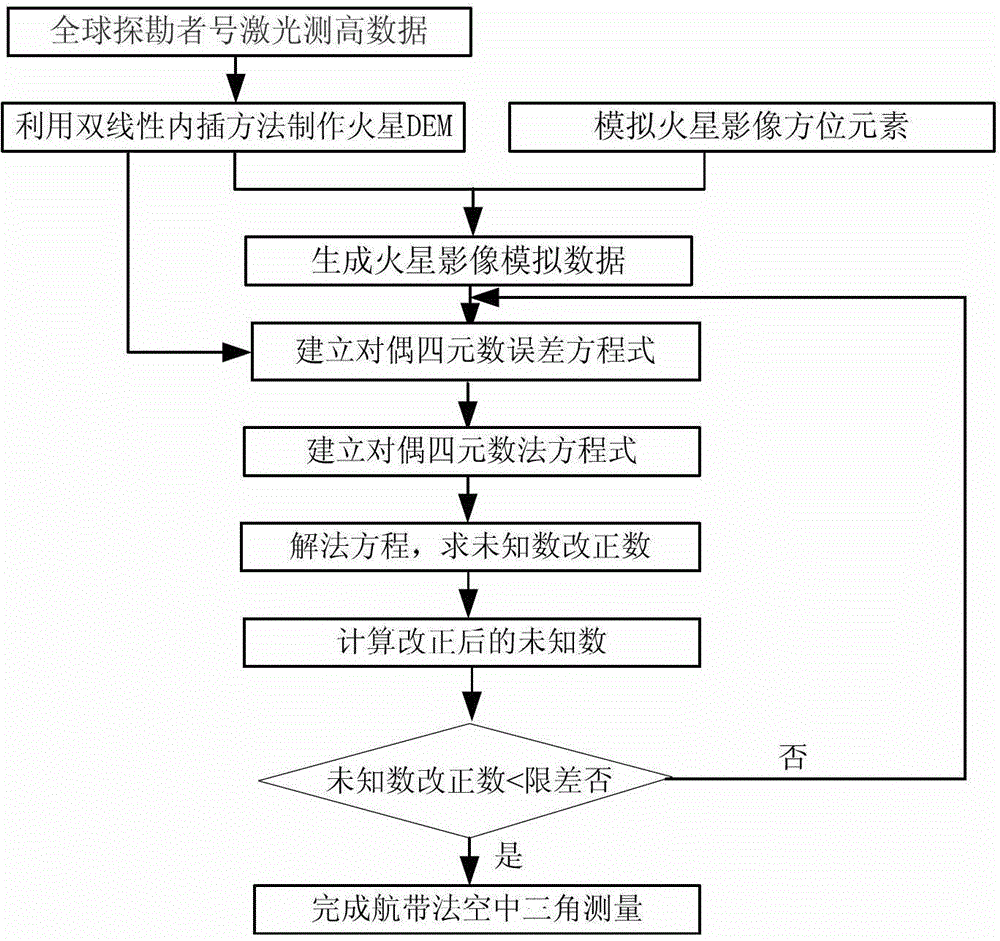
[0065] Below in conjunction with accompanying drawing, a kind of Mars DEM proposed by the present invention is made and aerial triangulation method of air belt method is described in detail:

[0066] Such as figure 1 Shown, a kind of Mars DEM of the present invention is made and air belt method aerial triangulation method flow chart, and its implementation process is as follows:

[0067] The first step: make Mars DEM, the method is as follows:

[0068] ①Taking Mars at 11.2°-11.5° north latitude and 41.2°-42.5° east longitude as an example, there are 148 discrete data points of laser altimetry data. First, convert the MOLA data between the Martian geographic coordinates and the Martian tangential coordinates:

[0069] x y z = sin B ...


PUM


Abstract

The invention discloses a Mars DEM making and strip aerial triangulation method. According to the method, a mars probe laser-measured height data is used as the basic data source, the basic data source is subjected to conversion between mars geographical coordinates and mars tangent plane coordinates, and then, a high-precision mars DEM is generated by interpolation, and thus, the current blank space of mars DEM in China is solved; strip aerial triangulation is carried out through dual quaterion, the posture and the relative position of a time sequence analog image are uniformly processed by dual quaternion, integral geometric meaning is provided, and the iterative operation process is independent from the initial value, so that orientation elements and encrypted point coordinates of high-precision mars sequence image can be obtained.

Description

technical field [0001] The invention belongs to the technical field of deep space surveying and mapping, and in particular relates to a method for making a Mars DEM and an aerial triangulation method using an aerial belt method. Background technique [0002] Mars is the first planet located outside the orbit of the earth. It has a special attraction for human beings. It is one of the closest celestial bodies in the solar system to the earth. The intersection angle between the equatorial plane and the orbital plane of Mars is very close to that of the Earth, which makes it have four seasons similar to that of the Earth. It is the planet that humans are most interested in and explores most frequently outside the Earth. Mars exploration is one of the five key research areas of deep space exploration in the 21st century. The history of humans using space probes to explore Mars has almost run through the entire history of human spaceflight. More than 30 probes from the United Sta...

Claims


Application Information

Patent Timeline
Patent Type & Authority Patents(China)
IPC IPC(8): G01C5/00G01C11/00
Inventor 盛庆红季铮刘微微王惠南
Owner NANJING UNIV OF AERONAUTICS & ASTRONAUTICS
Why Eureka
Try Eureka