Supercharge Your Innovation With Domain-Expert AI Agents!

Partition-Based Complete Surface Object Surveying and Mapping Operation Method

A feature and operation technology, applied in surveying and mapping and navigation, measuring devices, section drawing, etc., can solve problems such as hindering the improvement of data quality, losing data accuracy, increasing workload, etc., to reduce the workload of internal work, Eliminate the effect of cutting result data and eliminating the workload of stitching

Active Publication Date: 2015-12-02
天津市测绘院有限公司 +1
View PDF5 Cites 0 Cited by
  • Summary
  • Abstract
  • Description
  • Claims
  • Application Information

AI Technical Summary

Problems solved by technology

The framing in the existing surface object surveying and mapping method adopts rectangular framing or trapezoidal framing according to the "National Basic Scale Topographic Map Framing and Numbering". This kind of framing method has the following problems in surveying and mapping operations: 1. For example, if the house to be measured crosses the framing line, there is a part in each of the two pictures. If the two pictures are distributed to different survey teams for side repair, then in order to ensure the integrity of the ground features, the house It will be measured once by two surveying teams; due to the limitation of framing and natural conditions, field surveying / mapping is often transferred to the opposite bank because the map crosses the river, and the results of the piece-by-piece measurement need to be cut into framing results , which increases the workload, also causes inconvenience to the work, and destroys the integrity; 2. In the office, whether it is new surveying, editing, repairing, or downsizing, edge joining is a necessary process, and the work of edge joining The amount of data is very large, which takes up a lot of time for data processing, and errors and errors in the joining process are unavoidable, which will artificially lose data accuracy and hinder the improvement of data quality

Method used


Image

  • Partition-Based Complete Surface Object Surveying and Mapping Operation Method

Examples


Embodiment Construction

[0014] The present invention will be described in further detail below through specific examples. The following examples are only descriptive, not restrictive, and cannot limit the protection scope of the present invention.

[0015] A method for surveying and mapping of complete surface features based on partitions, the steps are as follows:

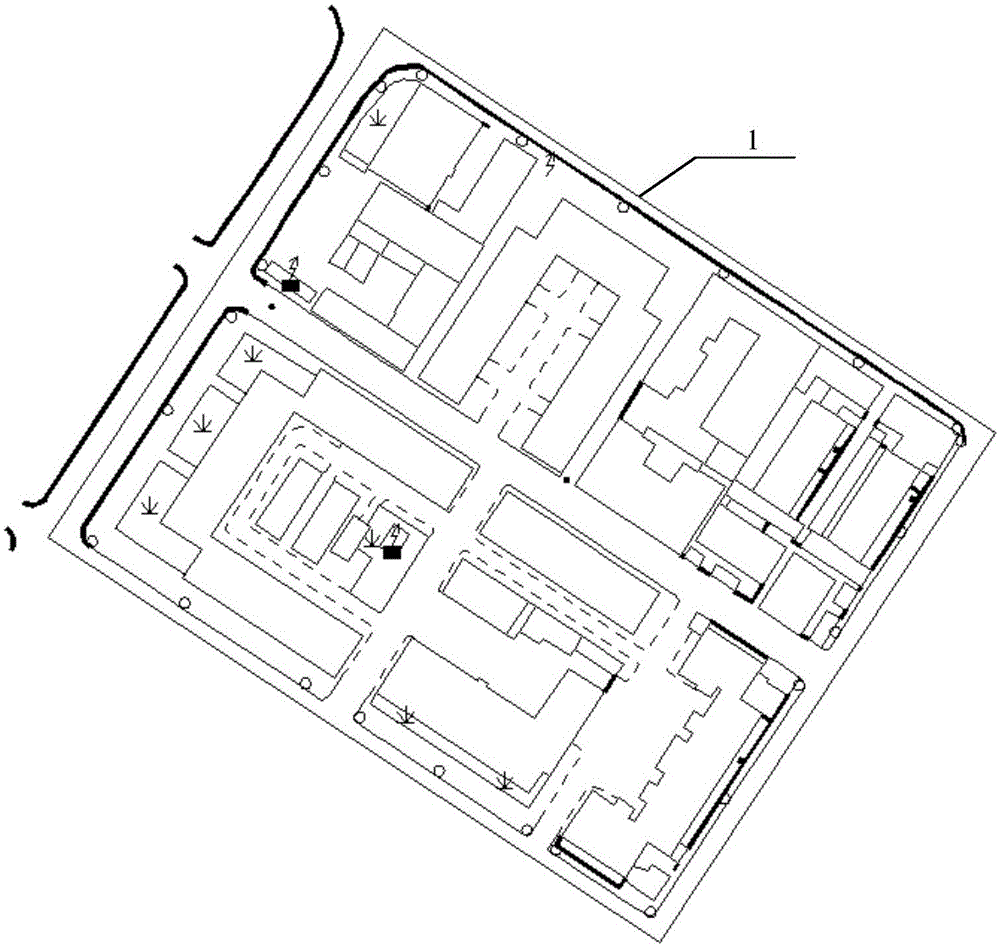
[0016] ⑴. Subdivision of ground objects: Divide the measured ground objects into divisions to form measurement units. Between each measurement unit, the cadastral street, square boundary, water system centerline and road centerline are used as the dividing line 1 to maintain the integrity of the ground objects. The corresponding borders between adjacent measurement units coincide, the boundary line of rivers and ditches in the measured objects is set on the right or below the centerline of the water system, and the boundary line of the road in the measured object is set on the right or below the centerline of the road , to maintain the i...


PUM


Abstract

The invention relates to an integral ground feature mapping working method based on partitioning. The integral ground feature mapping working method comprises the following steps: (1) partitioning ground features: partitioning the ground features to be detected to form measuring units, wherein all the measuring units take a cadastral street, a lane boundary line, a water system central line and a road central line as boundary lines so as to maintain the integrality of the ground features and corresponding side boundaries between the adjacent measuring units are overlapped; (2) carrying out field measurement; and (3) carrying out office work treatment. Aiming at a current working manner, the integral ground feature mapping working method is convenient for field annotation / mapping and the edge snapping work amount of office work is reduced; the partitioning is reasonable so that river-spanning and road-spanning work is reduced to the greatest extent and result data is prevented from being cut; the edge snapping work amount is eliminated basically and the integrality of the ground features is maintained to the greatest extent. The integral ground feature mapping working method based on the partitioning is applicable to a field working mode; the edge snapping work amount is nearly zero and the edge snapping work amount of traditional framing data accounts for 1%-3% of the working amount of a whole picture; the integrality of the ground features is effectively maintained and the integral ground feature mapping working method is applicable to data management.

Description

technical field [0001] The invention belongs to the field of surveying and mapping operations, in particular to a partition-based complete surface object surveying and mapping operation method. Background technique [0002] At present, my country's basic surveying and mapping operation mode can be roughly summarized as: field surveying / repair surveying by map sheet-in-house processing-arrangement and storage. The framing in the existing surface object surveying and mapping method adopts rectangular framing or trapezoidal framing according to the "National Basic Scale Topographic Map Framing and Numbering". This kind of framing method has the following problems in surveying and mapping operations: 1. For example, if the house to be measured crosses the framing line, there is a part in each of the two pictures. If the two pictures are distributed to different survey teams for side repair, then in order to ensure the integrity of the ground features, the house It will be measu...

Claims


Application Information

Patent Timeline
Patent Type & Authority Patents(China)
IPC IPC(8): G01C7/02
Inventor 周奎赵勇冯涛宋军张胜柱王冬
Owner 天津市测绘院有限公司
Features
  • R&D
  • Intellectual Property
  • Life Sciences
  • Materials
  • Tech Scout
  • Unparalleled Data Quality
  • Higher Quality Content
  • 60% Fewer Hallucinations
Learn More