Method for collecting map information, server and user terminal

A user terminal, map information technology, applied in the field of network communication, can solve the problems of slow response, inaccurate location, long data return period, etc., and achieve the effect of comprehensive attributes, fast response, and accurate location.

Active Publication Date: 2017-10-13
BAIDU ONLINE NETWORK TECH (BEIJIBG) CO LTD
View PDF7 Cites 0 Cited by
  • Summary
  • Abstract
  • Description
  • Claims
  • Application Information

AI Technical Summary

Problems solved by technology

[0004] In view of this, the purpose of the embodiment of the present invention is to propose a method for collecting map information, a server and a user terminal to solve the problem of slow response, long data return period, incomplete collected information and inaccurate location in the prior art. technical problem

Method used


Image

  • Method for collecting map information, server and user terminal
  • Method for collecting map information, server and user terminal
  • Method for collecting map information, server and user terminal

Examples


Embodiment Construction

[0025] Hereinafter, the present invention is described by means of specific embodiments shown in the drawings. It should be understood, however, that these descriptions are exemplary only and are not intended to limit the scope of the present invention. Also, in the following description, descriptions of well-known structures and techniques are omitted to avoid unnecessarily obscuring the concept of the present invention.

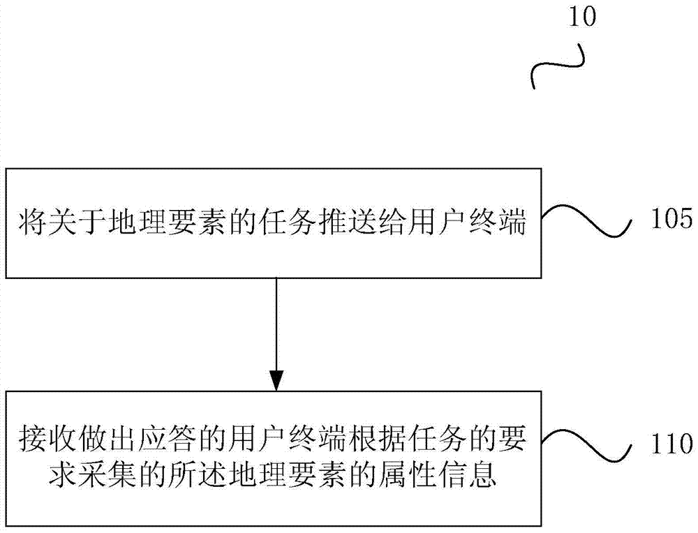
[0026] figure 1 A method 10 for collecting map information according to a first embodiment of the present invention is shown, the method includes:

[0027] Step 105 , pushing the tasks related to geographical elements to the user terminal.

[0028] Specifically, geographical elements refer to the geographical content of the map, including elements that represent the natural form of the earth's surface, such as natural geographical elements such as landforms, water systems, vegetation, and soil, and elements formed by humans transforming nature in producti...


PUM


Abstract

The invention discloses a method for collecting map information, a server and a user terminal. The method includes the following steps: pushing the task about the geographic element to the user terminal; and receiving the attribute information of the geographic element collected by the user terminal that responds according to the task requirement. Utilizing the method, server and user terminal of the present invention can realize the effects of "quick response, accurate location and comprehensive attributes" for the proposed task about geographic elements.

Description

technical field [0001] The invention relates to the technical field of network communication, in particular to a method for collecting map information, a server and a user terminal. Background technique [0002] Internet, mobile Internet and other electronic maps are a map service method realized by using mature network technology, communication technology, and GIS (Geographic Information System, Geographic Information System) technology. Various handheld terminal devices such as mobile phones, PDAs (Personal Digital Assistants, personal digital assistants), and tablet computers can carry such electronic maps. With the rapid development and popularization of network technology, Internet and mobile Internet map applications have higher and higher requirements for geographic data, such as not only wanting to know the address of a certain store, but also wanting to know the name, contact number, contact person and other information. [0003] For the collection of geographic da...

Claims


Application Information

Patent Timeline
Patent Type & Authority Patents(China)
IPC IPC(8): H04L29/08G06F17/30
Inventor 熊伟陈启文尹颂扬
Owner BAIDU ONLINE NETWORK TECH (BEIJIBG) CO LTD
Why Eureka
Try Eureka