Adjustment method of sub-segment background difference of geophysical and geochemical exploration data

An adjustment method, a technology of geophysical and geochemical exploration, applied in image data processing, instruments, calculations, etc., can solve problems such as "step" shape, and achieve the effects of uniform scale, strong operability, and easy operation.

Inactive Publication Date: 2014-05-07
BEIJING RES INST OF URANIUM GEOLOGY
View PDF4 Cites 5 Cited by
  • Summary
  • Abstract
  • Description
  • Claims
  • Application Information

AI Technical Summary

Problems solved by technology

However, for the acquisition of data in larger areas, due to the large area, the data of adjacent areas are often obtained in stages or years, and the data may also be analyzed and measured by measuring instruments with different sensitivities or different laboratories. Adding adjustments and directly using it to compile the iso-value map will inevitably cause a "step" appearance on the map due to the difference in the background value. At the same time, it will also suppress the abnormalities in some areas with low average values, resulting in distortion. Therefore, there is necessary adjustments to the data

Method used


Image

  • Adjustment method of sub-segment background difference of geophysical and geochemical exploration data
  • Adjustment method of sub-segment background difference of geophysical and geochemical exploration data
  • Adjustment method of sub-segment background difference of geophysical and geochemical exploration data

Examples


Embodiment Construction

[0020] A method for adjusting the sub-area background differences caused by human factors in the creation of contour maps provided by the present invention will be described in detail below in conjunction with the accompanying drawings and embodiments.

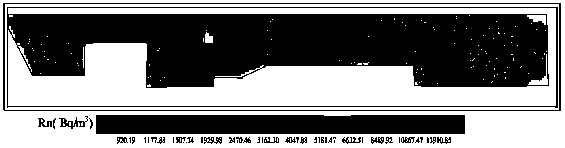
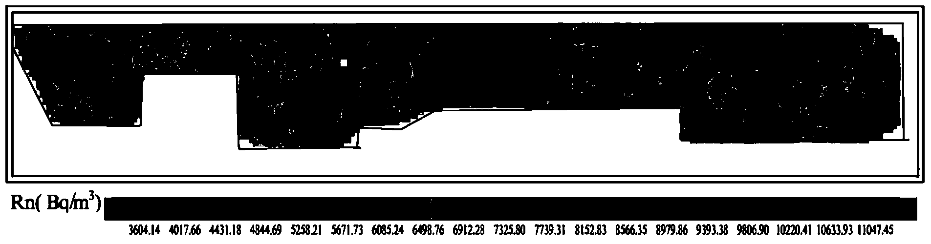
[0021] like figure 1 As shown, a method for adjusting the sub-area background difference of geophysical and geochemical prospecting data includes the following steps:

[0022] Step S1: Divide the geophysical and geochemical data measured in different years or by different methods in the entire map area into several sub-map areas, and calculate the average value and standard deviation of the sub-map areas according to the sub-map areas. In order to make the calculation accurate and convenient for subsequent use, when calculating the average value and standard deviation of each sub-map area, it is necessary to repeatedly calculate and eliminate data points and Data points that are less than negative n times the standard deviati...


PUM


Abstract

The invention belongs to the processing field of geophysical and geochemical exploration data, and particularly relates to an adjustment method of the sub-segment background difference of geophysical and geochemical exploration data in order to eliminate the background difference caused by difference of the measurement year of data, or measurement methods or measurement batches when a contour map is made through the geophysical and geochemical exploration data. The method includes the steps that the geophysical and geochemical exploration data measured in different years or measurement with different methods are divided into a plurality of sub-image areas, and the average value and the standard deviation of all the sub-image areas are calculated; the average value of the sub-image areas with the largest-area image dimension is selected as a reference background value, and data of the other sub-image areas are adjusted according to the reference background value; all data points of the adjusted sub-areas are calculated to serve as a whole to obtain the average value, and a planar contour diagram is made again. With the method, the data measurement in different years, by different instruments and in different batches can be adjusted to one area background for making the contour diagram so that the whole area can have a uniform background value, and abnormity of a low-value film area is highlighted.

Description

technical field [0001] The invention belongs to the field of geophysical and chemical prospecting data processing, and specifically relates to a method for adjusting background differences of sub-regions of geophysical and geochemical prospecting data, which is suitable for use of geophysical and geochemical prospecting data when compiling contour maps, due to different measurement years, different measurement methods or Elimination of background differences caused by different batches of measurements. Background technique [0002] After the geophysical and geochemical prospecting data are obtained, it is necessary to compile an isomap to analyze and utilize the data. However, for the acquisition of data in larger areas, due to the large area, the data of adjacent areas are often obtained in stages or years, and the data may also be analyzed and measured by measuring instruments with different sensitivities or different laboratories. Adding adjustments and directly using it...

Claims


Application Information

Patent Timeline
Patent Type & Authority Applications(China)
IPC IPC(8): G06T7/00
Inventor 李林强赵宁博宁斯同
Owner BEIJING RES INST OF URANIUM GEOLOGY
Why Eureka
Try Eureka