Forest fire hazard emergency command decision management GIS three-dimensional platform

A technology of emergency command and forest fire, applied in the direction of climate change adaptation, data processing application, resources, etc., can solve the problems of disaster loss, casualties, ineffective deployment of manpower and material resources, etc., to ensure personal safety and ensure fire protection The effect of fire supply

Inactive Publication Date: 2014-05-28
郭志华
View PDF5 Cites 36 Cited by
  • Summary
  • Abstract
  • Description
  • Claims
  • Application Information

AI Technical Summary

Benefits of technology

This technology allows for quicker understanding by firefighters about their location or movement within fires during times when they are facing hazards such as rainwater damage from flooding caused by heavy snowfall on roads near them. It also includes tools like radar guns that help identify potential sources of water intrusions, allowing officers to take appropriate actions accordingly. Overall, this system improves efficiency in responding to emergency situations while minimizing human error associated with traditional methods used to protect against fires.

Problems solved by technology

This patented describes how it works with various systems that help save time during emergency situations by providing precise data about areas around where fires are happening or their impacting factors like weather patterns. However, current methods rely heavily upon human judgment rather than science alone making decisions based solely on visual cues provided through these tools. Additionally, existing maps may be incomplete without detailed knowledge of environmental variables like temperature and precipitation levels.

Method used


Image

  • Forest fire hazard emergency command decision management GIS three-dimensional platform
  • Forest fire hazard emergency command decision management GIS three-dimensional platform
  • Forest fire hazard emergency command decision management GIS three-dimensional platform

Examples


Embodiment Construction

[0038] Below in conjunction with accompanying drawing and embodiment the present invention will be further described:

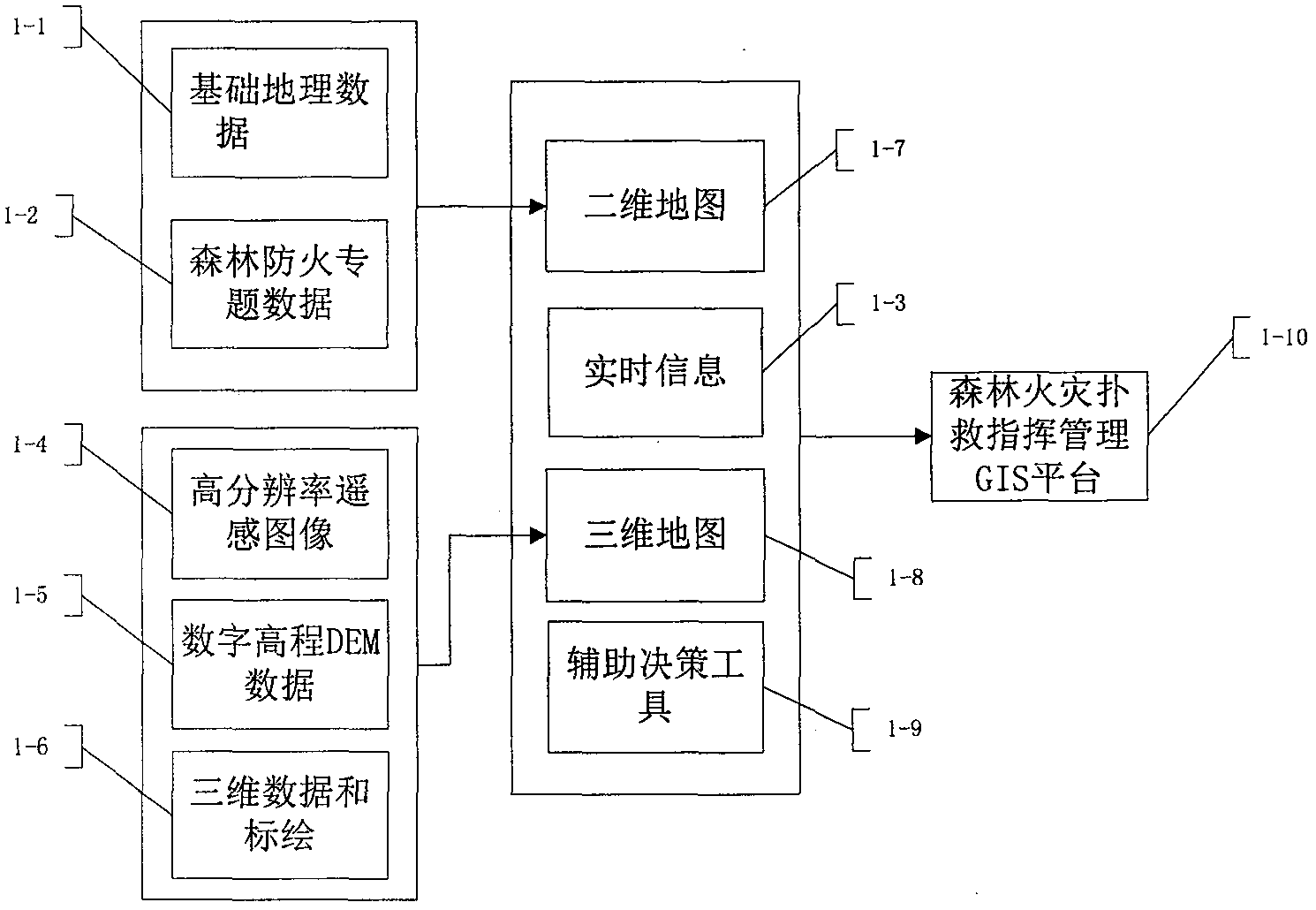
[0039] Such as figure 1 As shown: the present invention adopts the two-dimensional and three-dimensional map linkage method to realize the real simulation of the fire scene; at the same time, real-time wireless remote monitoring information of the fire scene is obtained, and the purpose of remote and scientific command is achieved through auxiliary decision-making tools. two-dimensionally Figure 1-7 Including: basic geographic data 1-1, forest fire prevention special data 1-2. three-dimensionally Figure 1-8 (High-precision 3D electronic sand table) includes: high-resolution satellite / aerial remote sensing images 1-4, digital elevation DEM data 1-5, 3D data and plotting 1-6. Digital elevation DEM data 1-5 are maps with a scale of 1:10,000 or larger, and the high spatial resolution digital elevation data DEM established; the high-precision three-dimensiona...


PUM


Abstract

The invention discloses a forest fire hazard emergency command decision management GIS three-dimensional platform. The platform comprises a high-precision three-dimensional electronic sand table, basic geographic data management, forest fire prevention thematic data management and map display, real-time meteorology display, fire scene real-time meteorology, real-time video monitoring, fire scene real-time videoing, vehicle personnel positioning tracking and command navigation, three-dimensional simulation control, forest fire diffusion simulation and map display, trend plotting management, and a three-dimensional analysis tool. By using the platform provided by the invention, a fire suppression commander can master fire scene meteorology and fire development trend and change in real time, master the positions of fire fighters and vehicles and travel routes in real time, and accurately master the distribution and quantity of fireproof materials, scientific and effective strategies and tactics and fire suppression schemes can be mapped out, fire suppression personnel and materials can be rapidly scheduled, various fire suppression parties can be coordinated, personal safety of the fire suppression personnel can be guaranteed, fire suppression supply is ensured, and a fire can be extinguished in a highly-efficient manner.

Description


Claims


Application Information

Patent Timeline
Owner 郭志华
Why Eureka
Try Eureka