
A Method for Earth Orientation in Remote Sensing Image of Large Cycloidal Array CCD

A remote sensing image and line array technology, applied in the field of satellite remote sensing image processing, can solve the problems of poor satellite image positioning accuracy, lack of satellite side swing factors, processing, etc., and achieve the effects of compensation for the influence of the earth's curvature and strict maintenance of geometric relationships

Active Publication Date: 2016-09-21
济钢防务技术有限公司
View PDF3 Cites 0 Cited by
  • Summary
  • Abstract
  • Description
  • Claims
  • Application Information

AI Technical Summary

Problems solved by technology

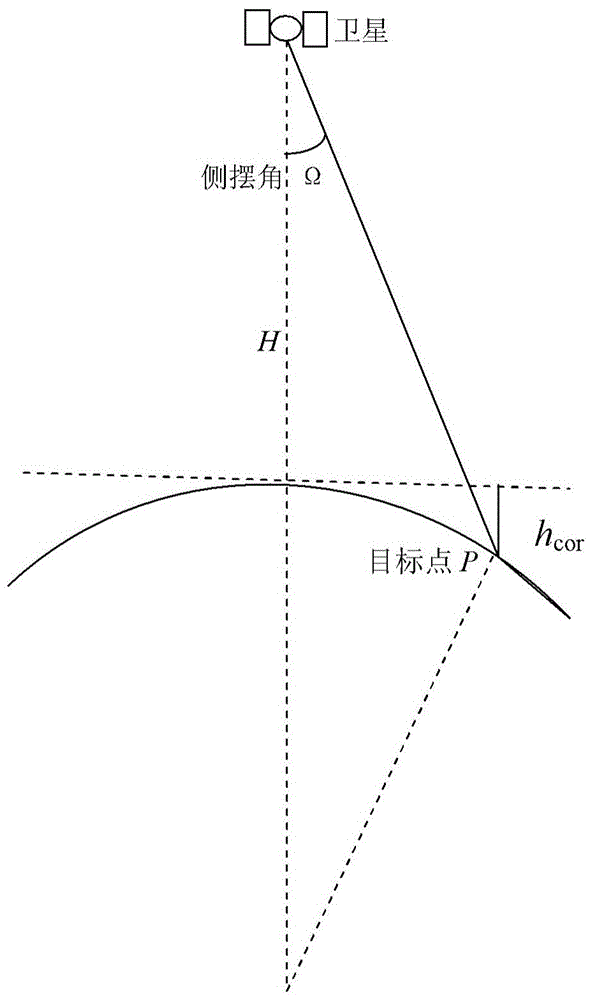
[0006] At present, the existing satellite image positioning methods lack the processing of satellite roll factors, and the earth is simplified into an ideal spherical model in the analysis of the impact of roll, resulting in poor positioning accuracy of satellite images

Method used


Image

  • A Method for Earth Orientation in Remote Sensing Image of Large Cycloidal Array CCD
  • A Method for Earth Orientation in Remote Sensing Image of Large Cycloidal Array CCD
  • A Method for Earth Orientation in Remote Sensing Image of Large Cycloidal Array CCD

Examples


Embodiment Construction

[0020] In order to make the object, technical solution and advantages of the present invention clearer, the present invention will be described in further detail below in conjunction with specific embodiments and with reference to the accompanying drawings. It should be noted that, in the drawings or descriptions of the specification, similar or identical parts all use the same figure numbers. Implementations not shown or described in the accompanying drawings are forms known to those of ordinary skill in the art. Additionally, while illustrations of parameters including particular values ​​may be provided herein, it should be understood that the parameters need not be exactly equal to the corresponding values, but rather may approximate the corresponding values ​​within acceptable error margins or design constraints. The directional terms mentioned in the embodiments, such as "upper", "lower", "front", "rear", "left", "right", etc., are only referring to the directions of the...


PUM


Abstract

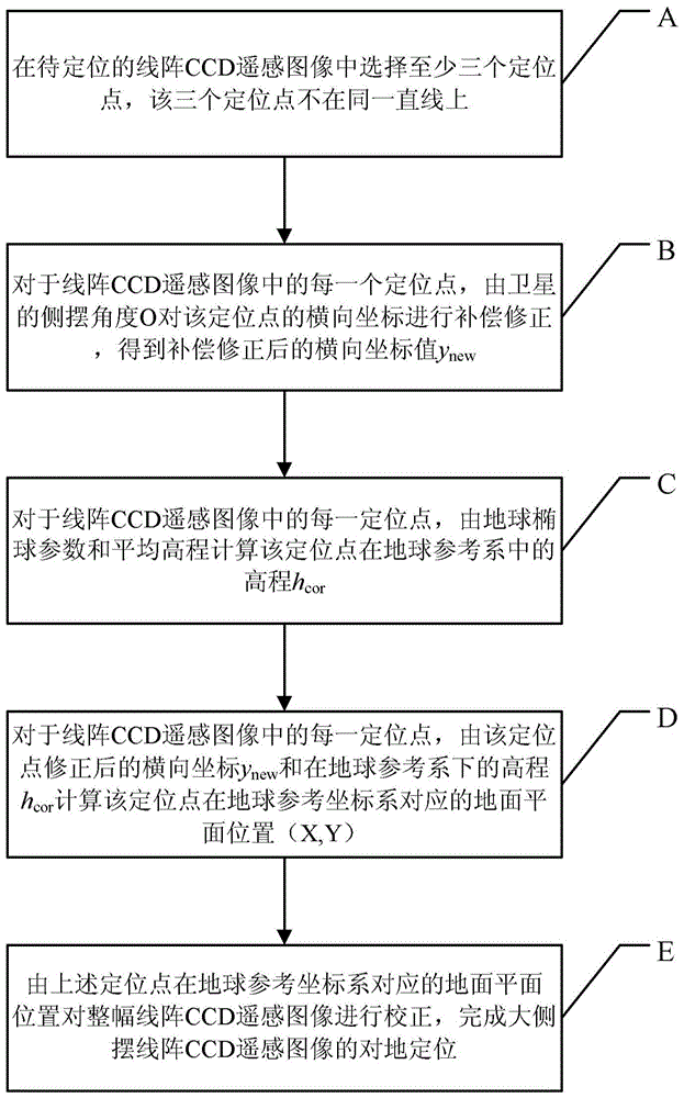
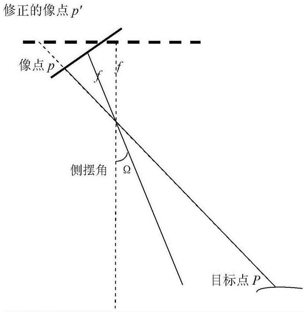
The invention provides a method for ground positioning by a remote sensing image of a large side-swaying linear array CCD (Charge Coupled Device). The method comprises the following steps of: (A) selecting at least three positioning points in the remote sensing image to be positioned of the linear array CCD; (B) carrying out compensation and correction on a transverse coordinate of the positioning point by a side-swaying angle Omega for each positioning point; (C) for each positioning point, calculating elevation hcor of the positioning point in a terrestrial reference system on the basis of a terrestrial ellipsoid parameter and an average elevation; (D) for each positioning point, calculating a corresponding ground plane position (X, Y) of the positioning point in the terrestrial reference system; and (E) correcting the whole remote sensing image of the linear array CCD according to the corresponding ground plane positions of at least three positioning points. The method provided by the invention has the advantages that the image-space coordinate of the remote sensing image of the linear array CCD is corrected and compensated according to the side-swaying angle of a satellite, and the geometrical relationship of the transverse coordinate of the image is maintained strictly when the satellite sways to one side.

Description

technical field [0001] The invention relates to the technical field of satellite remote sensing image processing, in particular to a method for ground positioning of a large lateral cycloid array CCD remote sensing image. Background technique [0002] Because satellite remote sensing images play a huge role in national economic construction, satellite remote sensing has developed rapidly. With the advancement of application requirements, satellite remote sensing images that can perform large sideways swings to both sides of the flight have a very flexible data acquisition mode, and play a unique role in emergency disaster reduction and other aspects. However, because the large-swing remote sensing satellite adopts a large-angle side swing to the side of the flight, it brings certain difficulties to the positioning of the remote sensing image. Here, the large side swing refers to the ability to swing to both sides of the flight direction at an angle greater than 20 degrees. ...

Claims


Application Information

Patent Timeline
Patent Type & Authority Patents(China)
IPC IPC(8): G01C11/00G01C11/04G01C25/00
CPCG01C11/04G01C25/00
Inventor 尤红建
Owner 济钢防务技术有限公司
Learn More