A car navigation method, system and electronic terminal

A car navigation and electronic map technology, applied in the field of car navigation, can solve the problems of difficulty in recognizing information and text information, and the inability of pictures to be zoomed and zoomed at will.

Active Publication Date: 2018-12-07
NAVINFO
View PDF3 Cites 0 Cited by
  • Summary
  • Abstract
  • Description
  • Claims
  • Application Information

AI Technical Summary

Problems solved by technology

[0005] The embodiment of the present invention provides a car navigation method, which aims to solve the problem that the existing grid image-based navigation system images cannot be zoomed in and out at will, and the information contained in the images, especially text information, is difficult to recognize

Method used


Image

  • A car navigation method, system and electronic terminal
  • A car navigation method, system and electronic terminal
  • A car navigation method, system and electronic terminal

Examples


Embodiment Construction

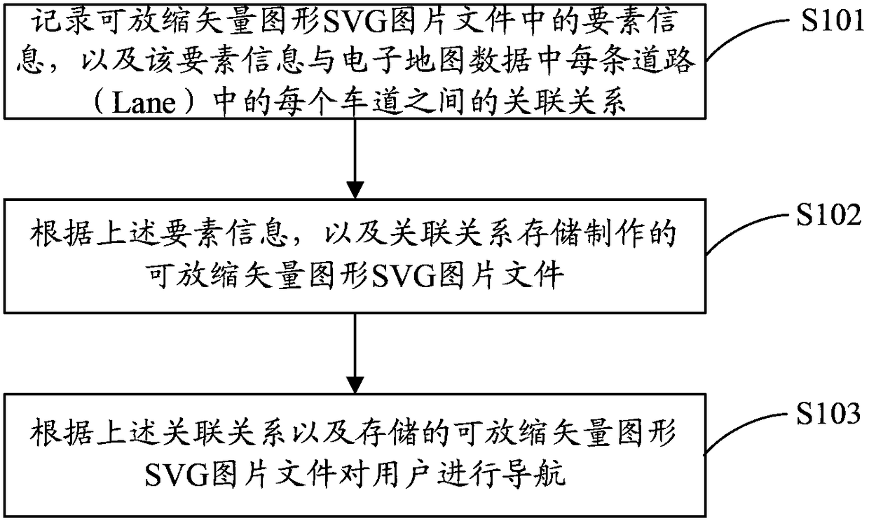
[0022] In order to make the object, technical solution and advantages of the present invention clearer, the present invention will be further described in detail below in conjunction with the accompanying drawings and embodiments. It should be understood that the specific embodiments described here are only used to explain the present invention, not to limit the present invention.

[0023] In the embodiment of the present invention, by recording the element information of the scalable vector graphics (Scalable Vector Graphics, SVG) picture, and the association relationship between the element information and each lane in each road in the electronic map data, according to the association Relationships and scalable vector graphics SVG image files for navigation.

[0024] figure 1 The implementation process of the car navigation method provided by the embodiment of the present invention is shown, and the details are as follows:

[0025] In step S101, record the element informat...


PUM


Abstract

The invention is applicable to the field of automobile navigation and provides an automobile navigation method and system and an electronic terminal. The method comprises the following steps: recording elemental information in picture files of scalable vector graphics (SVG) as well as incidence relations between the elemental information and lanes of roads in electronic map data; storing the made picture files of the SVG according to the elemental information and the incidence relations; and navigating an automobile of a user according to the incidence relations and the stored picture files of the SVG, wherein the picture files of the SVG are recorded in a layered mode, and each element on each layer has a unique marker. The text information in the pictures of the SVG can be called, and corresponding voice information is broadcast and output to the user. Along with change of distance between the automobile and a branching point, the size and definition of a board for outputting navigation pictures to the user are dynamically adjusted. The user can clearly and accurately master the information of the roads and ambient environments.

Description

technical field [0001] The invention is applicable to the field of car navigation, and in particular relates to a car navigation method, system and electronic terminal. Background technique [0002] Existing navigation systems provide users with navigation based on traditional grid images. These raster images are drawn using relevant professional software, and then associated with navigation data through file numbers. Raster images cannot be enlarged or reduced at will, because different users need to use images of different sizes and styles, and it is necessary to recreate images of different proportions and styles according to the needs of users. [0003] For the information contained in the picture, especially the text information, the navigation system cannot analyze it very well, and must give the user the necessary prompts through other auxiliary methods. For example, software is used to identify the information contained in the picture, and then the information is f...

Claims


Application Information

Patent Timeline
Patent Type & Authority Patents(China)
IPC IPC(8): G01C21/26G01C21/36
CPCG01C21/26G01C21/3629G01C21/3647
Inventor 邹翠张建平肖鸣晓
Owner NAVINFO
Why Eureka
Try Eureka