GIS (Geographic Information System) real estate valuation based data processing system and method

A data processing device and GIS server technology, applied in data processing applications, electrical digital data processing, special data processing applications, etc., can solve problems such as lack of initiative, failure to reflect the relationship between real estate and surrounding things, and inaccurate valuation results , to achieve the effect of optimizing the sample set

Inactive Publication Date: 2014-10-01
CHINA CONSTRUCTION BANK
View PDF1 Cites 12 Cited by
  • Summary
  • Abstract
  • Description
  • Claims
  • Application Information

AI Technical Summary

Problems solved by technology

[0004] 1: Since the user only needs to input the property to be evaluated, the user only passively accepts the valuation result during the valuation process, and the user has no initiative in the selection of the sample property and cannot make a reasonable judgment on the valuation result;
[0005] 2: The sample real estate is obtained by screening according to the preset rules, so the selection of sample real estate is relatively rigid, which leads to the inaccurate final valuation results and cannot more accurately reflect the true value of the real estate;
[0006] 3: The valuation process is closed, and the factors on which the valuation is based cannot be intuitively reflected at all, for example, the connection between the property and surrounding things (transportation, school district, location, etc.) cannot be reflected

Method used


Image

  • GIS (Geographic Information System) real estate valuation based data processing system and method
  • GIS (Geographic Information System) real estate valuation based data processing system and method
  • GIS (Geographic Information System) real estate valuation based data processing system and method

Examples


Embodiment Construction

[0032] In order to make the purpose, technical solutions and advantages of the embodiments of the present invention clearer, the present invention will be described in detail below in conjunction with the accompanying drawings.

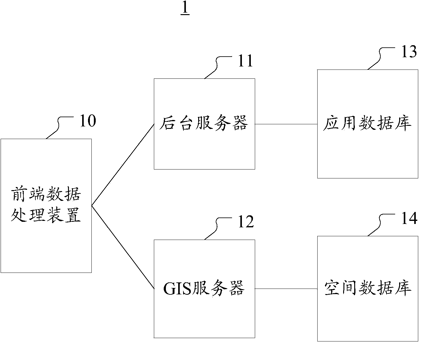
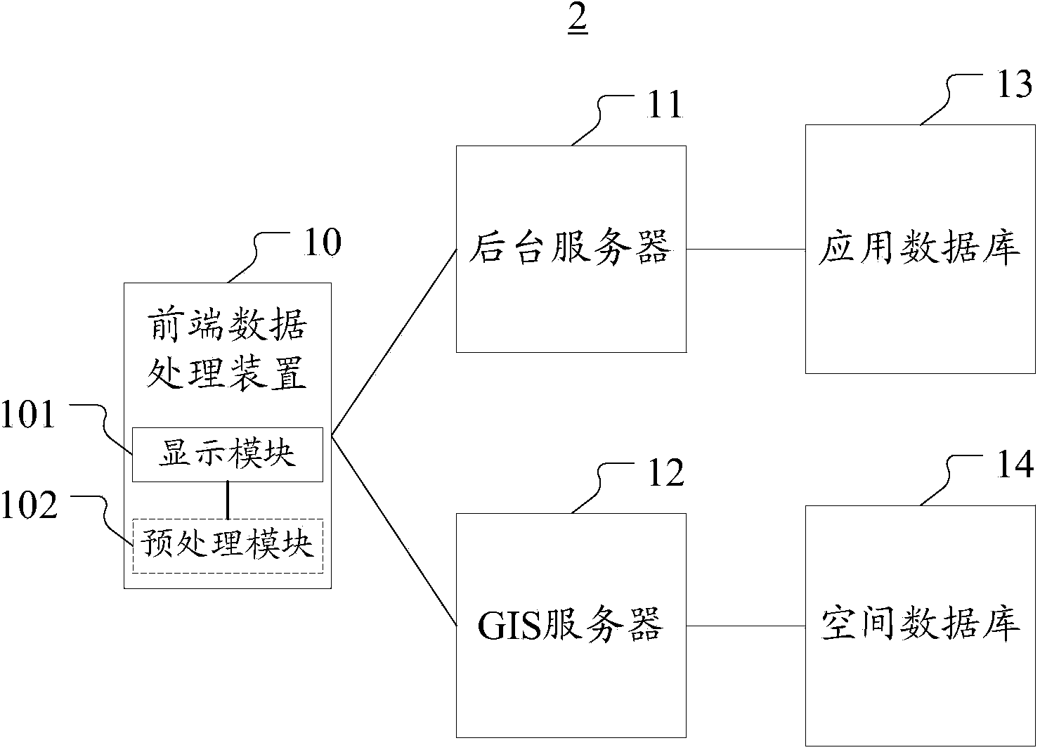
[0033] figure 1 It is a block diagram of a data processing system for real estate valuation based on GIS according to an embodiment of the present invention, refer to figure 1 , the data processing system 1 includes a front-end data processing device 10 , a background server 11 , a GIS server 12 , an application database 13 and a spatial database 14 . Detailed description will be given below.

[0034] The front-end data processing device 10 is used to obtain the name of the candidate cell within the preselected range from the spatial database 14 through the GIS server 12, and obtain the name of the candidate cell from the application database through the background server. basic information, and generate a list of candidate cells according to the na...


PUM


Abstract

The invention discloses a GIS (Geographic Information System) real estate valuation based data processing system and method. In the GIS real estate valuation based data processing system, a front-end data processing device is used for generating an alternative community list according to names of alternative communities and the basic information of the alternative communities and sending a selected alternative community list to a background server, wherein the names of the alternative communities are obtained from a spatial database and the basic information of the alternative communities is obtained from an application database; the background server is used for obtaining the real estate information of selected communities from the application database according to the selected alternative community list and sending the real estate information to the front-end data processing device; the front-end data processing device is also used for generating an alternative real estate list according to the real estate information of the selected communities and sending a sample real estate list to the background server; the background server is also used for performing valuation on a real estate to be valuated according to attribute data of the real estate to be valuated and attribute data of a sample real estate, wherein the attribute data of the real estate to be valuated and the attribute data of the sample real estate are obtained from the application database. According to the GIS real estate valuation based data processing system and method, a visual and objective sample set is provided for the users in a technical mode and accordingly real valuation results can be obtained.

Description

technical field [0001] The invention relates to the field of bank real estate data processing, in particular to a data processing system and method for evaluating real estate based on GIS. Background technique [0002] Mortgage loans account for more than 50% of the bank's credit business, of which real estate is the main collateral (hereinafter referred to as collateral). [0003] The traditional bank valuation focuses on the valuation of a single collateral. The method generally used is: first import the real estate data set from the external system, and then filter the sample real estate from the real estate data set according to the preset rules according to the real estate input by the user, and finally Valuation based on screened sample properties. This approach has the following problems: [0004] 1: Since the user only needs to input the property to be evaluated, the user only passively accepts the valuation result during the valuation process, and the user has no ...

Claims


Application Information

Patent Timeline
Patent Type & Authority Applications(China)
IPC IPC(8): G06F17/30G06Q40/02
CPCG06F16/29G06Q40/03
Inventor 陆登强袁进威贾世军单亮徐禄春马殿珉王康宇
Owner CHINA CONSTRUCTION BANK
Why Eureka
Try Eureka