
A Method for Acquiring Thematic Maps Based on Changes in Scale Levels

A technology of thematic maps and scales, applied in the field of online display of thematic maps, can solve problems such as changes and achieve the effect of overcoming disconnection

Active Publication Date: 2017-11-28
XIAN FUTURE INT INFORMATION CO LTD +1
View PDF2 Cites 0 Cited by
  • Summary
  • Abstract
  • Description
  • Claims
  • Application Information

AI Technical Summary

Problems solved by technology

[0004] The present invention proposes a method for acquiring thematic maps based on changes in scale levels, which solves the technical problem in the prior art that the content of thematic data cannot change with changes in scale levels

Method used


Image

  • A Method for Acquiring Thematic Maps Based on Changes in Scale Levels
  • A Method for Acquiring Thematic Maps Based on Changes in Scale Levels

Examples


Embodiment Construction

[0016] In order to more clearly introduce the method for obtaining the thematic map based on the change of the scale level proposed by the present invention, the specific implementation will be described in detail below in conjunction with the accompanying drawings:

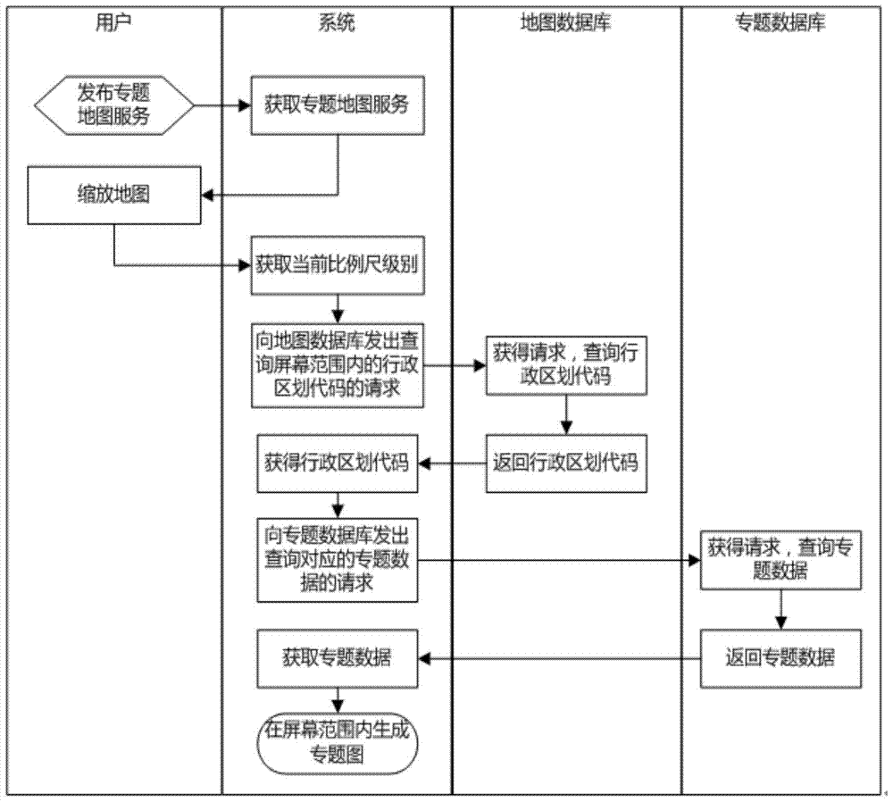
[0017] correspond figure 1 , the thematic map acquisition method based on the change of the scale level proposed by the present invention comprises the following steps:

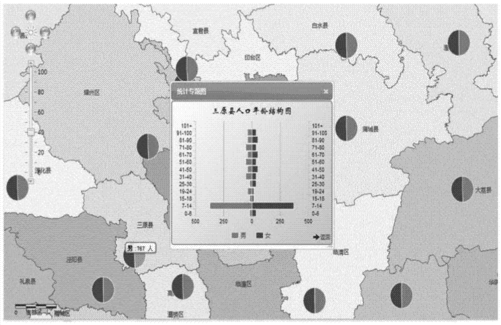
[0018] Step 1: Publish the thematic map data into sliced ​​thematic map services through third-party map software, and set ten scale levels, corresponding to figure 2 Ten levels of 10, 20, 30, 40, 50, 60, 70, 80, 90, and 100 are displayed on the scaling bar; the system obtains the thematic map through the interface provided by the third-party map software, corresponding to figure 2 Geographic base map; when the user uses the mouse to zoom the map according to the needs, the system obtains the current required scale level through the interface...


PUM


Abstract

The invention discloses a method for obtaining a thematic map based on scale level change. The method has the advantage that the query of scale levels for zooming a map by a user and the query of administrative division levels are combined, namely an administrative division code at a corresponding level is obtained by the user zooming scale level, thematic data is queried by the administrative division code, the problem of disjointing between the thematic map and a geographic base map in the traditional thematic map realizing scheme is solved, the thematic map can be changed based on the scale level, and the thematic data of the thematic map can be dynamically displayed on an online map in real time.

Description

technical field [0001] The invention belongs to the technical field of online display of thematic maps, and relates to a method for acquiring thematic maps based on scale level changes. Background technique [0002] A thematic map refers to a map that prominently and relatively fully represents one or several elements or natural phenomena, making the content of the map specialized. The content and form of thematic maps include nature, social economy, etc., focusing on the embodiment of thematic content, and are used for specific purposes such as scientific research and national economy. Traditional thematic maps or thematic atlases are mainly printed editions, which have a long production cycle and slow update time. With the development of computer technology, especially the development of Web GIS technology and distributed technology, thematic maps are displayed in the form of online thematic maps, that is, using computer technology, digitally stored, and based on screen d...

Claims


Application Information

Patent Timeline
Patent Type & Authority Patents(China)
IPC IPC(8): G06F17/30
CPCG06F16/29
Inventor 朱志祥王茜葛新李安颖刘盛辉王佩
Owner XIAN FUTURE INT INFORMATION CO LTD
Learn More