Remote-sensing-based method for estimating influences of area vegetation cover on earth surface air temperature

A technology of vegetation cover and air temperature, which is used in computing, special data processing applications, instruments, etc.

Active Publication Date: 2015-04-22
NORTHEAST INST OF GEOGRAPHY & AGRIECOLOGY C A S
View PDF1 Cites 18 Cited by
  • Summary
  • Abstract
  • Description
  • Claims
  • Application Information

AI Technical Summary

Problems solved by technology

[0004] The purpose of this invention is to solve the problem that the existing research on the feedback of vegetation to climate fails to combine the change of v

Method used


Image

  • Remote-sensing-based method for estimating influences of area vegetation cover on earth surface air temperature
  • Remote-sensing-based method for estimating influences of area vegetation cover on earth surface air temperature
  • Remote-sensing-based method for estimating influences of area vegetation cover on earth surface air temperature

Examples


specific Embodiment approach 1

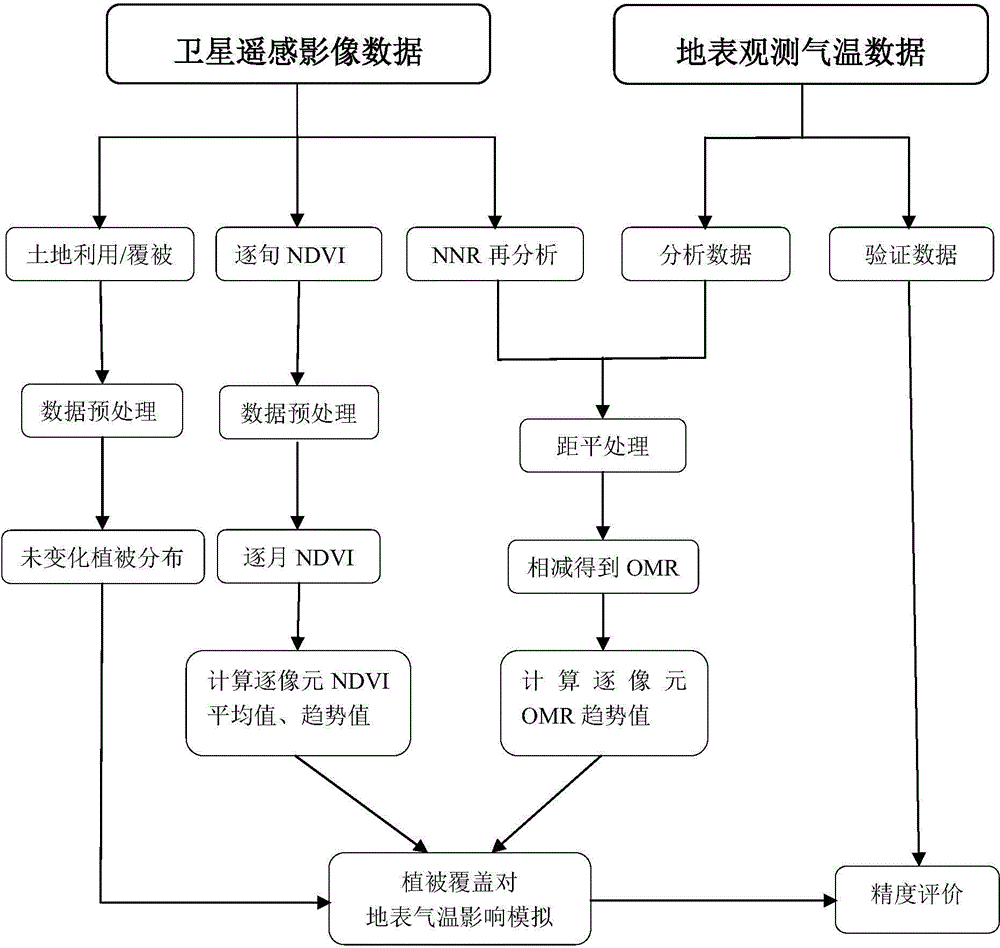
[0023] Specific implementation mode one: a method for estimating the impact of regional vegetation coverage on surface air temperature based on remote sensing in this embodiment is implemented in the following steps:

[0024] Step 1. Obtain the normalized difference vegetation index NDVI data set covering the study area, the NNR reanalysis air temperature data set, the surface observation air temperature grid point data set, and the land use / cover data of the start and end years of the research period, and perform data preprocessing ;

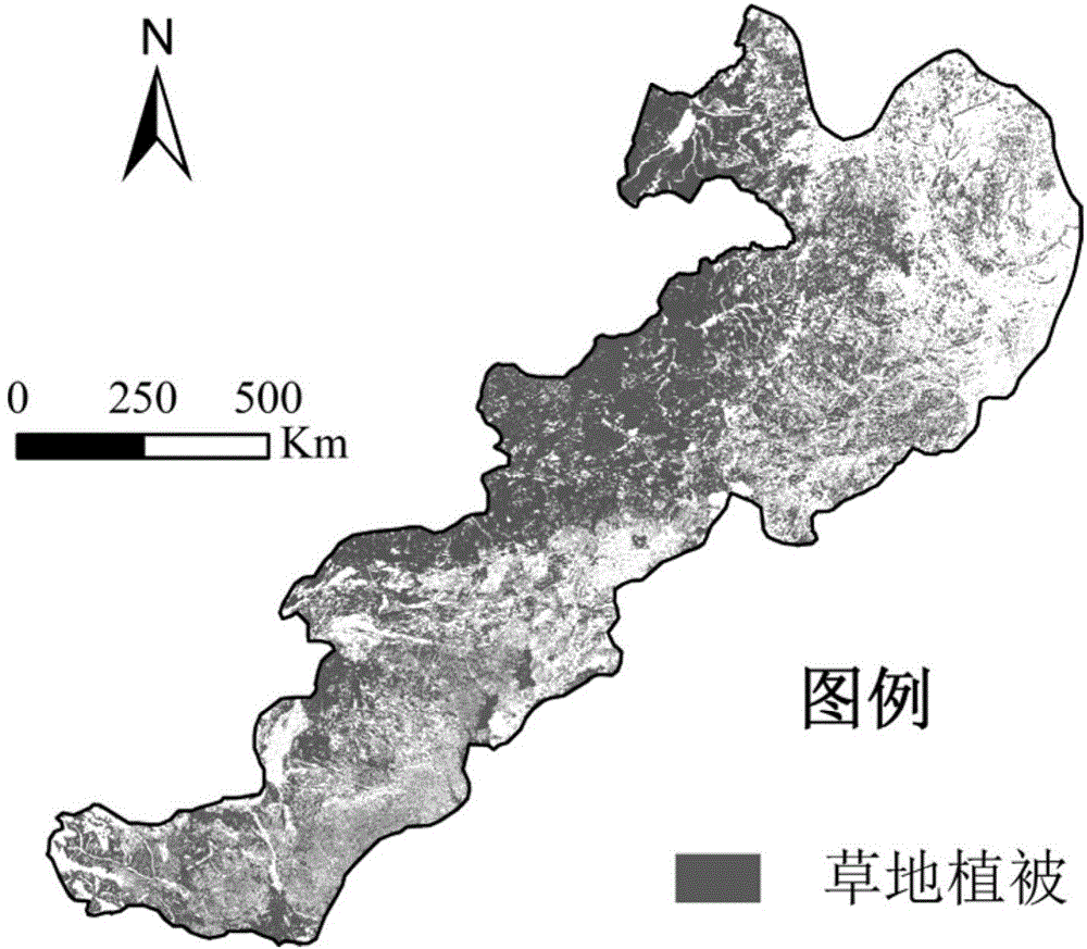
[0025] Step 2. According to the two periods of land use / cover data in the beginning and end years of the research period, extract the distribution of a certain vegetation type that has not undergone land use change during the research period;

[0026] Step 3: Remove the NNR and then analyze the annual average of the air temperature data set and the surface observation air temperature grid point data set in the entire research period, so as to r...

specific Embodiment approach 2

[0032] Specific implementation mode two: the difference between this implementation mode and specific implementation mode one is: said step one: the data preprocessing process is:

[0033] Step 1: Perform projection transformation on the four data sets and unify them under the same coordinate system and projection;

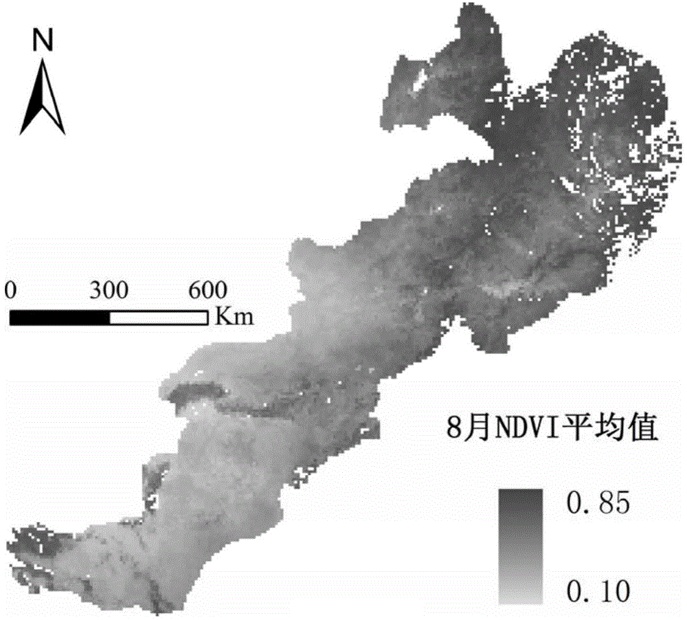
[0034] Step 12: Synthesize the ten-day NDVI data into the monthly NDVI value by using the maximum value synthesis method.

[0035] Other steps and parameters are the same as those in Embodiment 1.

specific Embodiment approach 3

[0036] Specific embodiment three: the difference between this embodiment and specific embodiment one or two is that: said step six: the calculation and publicity of the change trend value of NDVI by pixel and the trend value of OMR temperature change by pixel is as follows:

[0037] SLOPE NDVI = n * Σ i = 1 n i * NDVI i - ( Σ i = 1 n i ) ( Σ i = ...


PUM


Abstract

The invention discloses a remote-sensing-based method for estimating influences of area vegetation cover on the earth surface air temperature, and relates to a method for simulating the influences of area vegetation cover on the earth surface air temperature. The method aims at solving the problem that existing research related to the feedback of vegetation to climate can not be combined with changes of vegetation cover along with time, and includes the steps of 1, obtaining data of a cover research area, and carrying out preprocessing; 2, extracting the distribution of a certain vegetation type without land use changes within a research time period; 3, achieving anomaly processing of data of earth-surface air temperature observing lattice points; 4, obtaining OMR air temperature values of the lattice points; 5, rasterizing OMR air temperature data; 6, calculating pixel NDVI change trend values and pixel OMR air temperature change trend values; 7, extracting NDVI annual average values, the NDVI change trend values and the OMR air temperature change trend values of all pixels within the whole research time period; 8, building an OMR air temperature forecasting model. The remote-sensing-based method is applied to the field of eco-climate researching.

Description

technical field [0001] The invention relates to a method for simulating the influence of regional vegetation coverage on surface air temperature, in particular to a method for estimating the vegetation coverage status and the influence of dynamic changes on surface air temperature through remote sensing data and ground observation air temperature data. Background technique [0002] Human activities can have an important impact on climate change, the two main aspects of which are greenhouse gas emissions and land use / cover change. However, since both tend to increase surface air temperature, it is difficult to separate the impact information of land use / cover change on local climate from the background of global warming from observational data, so more research is devoted to numerical Analog aspect. Recently, Kalnay and Cai (2003) proposed an "Observation Minus Reanalysis" (Observation Minus Reanalysis, OMR for short) method to estimate the impact of land use / cover change on...

Claims


Application Information

Patent Timeline
IPC IPC(8): G06F19/00
Inventor 神祥金周道玮
Owner NORTHEAST INST OF GEOGRAPHY & AGRIECOLOGY C A S
Why Eureka
Try Eureka