Space domain and frequency domain combined vector spatial data multi-blind watermarking method

A vector space, combined technology, applied in the field of vector geospatial data blind watermarking algorithm, can solve the problems of data loss of protection, deletion, watermark destruction, etc., to achieve good resistance to geometric attacks, good practicability, and strong anti-attack ability Effect

Active Publication Date: 2015-06-03
LANZHOU JIAOTONG UNIV
View PDF2 Cites 14 Cited by
  • Summary
  • Abstract
  • Description
  • Claims
  • Application Information

AI Technical Summary

Problems solved by technology

If the watermark is not robust in some way, it will cause the watermark to be destroyed or deleted, and the data will lose protection

Method used


Image

  • Space domain and frequency domain combined vector spatial data multi-blind watermarking method
  • Space domain and frequency domain combined vector spatial data multi-blind watermarking method
  • Space domain and frequency domain combined vector spatial data multi-blind watermarking method

Examples


Embodiment Construction

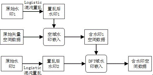
[0030] In order to describe the technical content, structural features, objectives and effects of the present invention in detail, the following will be described in detail in conjunction with specific embodiments.

[0031] Spatial Watermark Embedding Algorithm

[0032] This algorithm embeds watermarks in units of vector graphic objects1. The specific embedding algorithm flow is as follows:

[0033] (1) Read the vector geospatial data, extract the X and Y values ​​of the coordinate points, and extract the high-order significant part of the coordinate value of the spatial data, denoted as i x , i y ;

[0034] (2) Calculate Hash(i x ) and Hash(i y ), the Hash() function is a hash mapping function between coordinate points and watermark bits;

[0035] (3) Extract the watermark bit w[i](1 ), w is the watermark after scrambling, and M is the length of the watermark;

[0036] (4) Use the QIM method to embed the watermark in the coordinate point, take the quantization value ...


PUM


Abstract

Digital watermarking is considered as an effective digital map copyright protection method. If a watermark has low robustness on a certain aspect, the watermark can be caused to be damaged or deleted, so that data protection can be lost. Currently, for a vector spatial data watermark, a vector spatial data watermark algorithm can be divided into a space domain watermark algorithm and a frequency domain watermark algorithm according to an embedded position of the watermark. However, most of the watermark algorithms adopt a single watermarking technology and each watermarking technology is realized on the basis of one algorithm routine. Vector spatial data adopt a single digital watermarking technology usually cannot resist to various different types of attacks. Aiming at the problem that the single watermark algorithm is difficult to resist to various watermarking attacks, the invention constructs a novel space domain and frequency domain combined vector spatial data multi-blind watermarking method. According to the method, by carrying out chaotic scrambling on a watermark image, a Hash one-way mapping function between the watermark and carrier data is established, and two different embedding methods are used and the watermark is sequentially embedded into a space domain and a frequency domain. The watermark is repeatedly embedded so as to implement blind extraction of the watermark.

Description

technical field [0001] The invention belongs to the field of cartography and geographic information science and technology, and is a blind watermarking algorithm for vector geographic spatial data combining air domain and transformation domain. Background technique [0002] Vector geospatial data is an important strategic information resource of the country, and it is the basic data of economy, military affairs, national defense construction and social development. The acquisition usually requires the help of expensive professional equipment and a lot of manpower and material resources. Therefore, its copyright protection important. Vector geospatial data is stored in digital form, which makes piracy extremely easy while facilitating data copying and dissemination. At present, there is an urgent need for reliable technology to ensure the security of geospatial data, and digital watermarking is considered to be an effective method for copyright protection of digital maps. ...

Claims


Application Information

Patent Timeline
Patent Type & Authority Applications(China)
IPC IPC(8): G06T1/00
Inventor 闫浩文张黎明张永忠齐建勋张立峰
Owner LANZHOU JIAOTONG UNIV
Why Eureka
Try Eureka