Method and system for error judgment of topographic map measurement system

A measurement system and system error technology, applied in the field of surveying and mapping, can solve the problems of consuming time, manpower, material resources and financial resources, hindering the update of topographic maps, increasing the workload of internal processing, etc., and achieve the goal of saving survey work and saving human and material resources Effect

Inactive Publication Date: 2017-11-10
BEIJING INST OF SURVEYING & MAPPING
View PDF3 Cites 0 Cited by
  • Summary
  • Abstract
  • Description
  • Claims
  • Application Information

AI Technical Summary

Problems solved by technology

Although aerial image mapping has a sound theoretical basis and a relatively mature production process, it has the following defects: (1) Due to the low aerial photography height when acquiring aerial images, the quality of aerial images is less affected by the atmosphere and terrain. Seriously, before taking aerial photography, it is necessary to investigate the climate, weather, terrain, etc. (2) Since the image size of the aerial camera is generally 23cm×23cm, affected by the height of the flight, it covers a small area, and the number of aerial images required for surveying and drawing topographic maps of larger areas is relatively large. Therefore, the number of control points required for measurement in the field is also large, and at the same time increases the workload of the office processing, consuming a lot of time, manpower, material and financial resources; (3) can not be measured in some special cases Maps, such as: border mapping, no-man's land mapping, no-fly zone mapping, etc.
At present, when using satellite remote sensing images for topographic map measurement, when performing aerial triangulation of stereo image pairs, there are systematic errors usually after block adjustment.

Method used


Image

  • Method and system for error judgment of topographic map measurement system
  • Method and system for error judgment of topographic map measurement system
  • Method and system for error judgment of topographic map measurement system

Examples


Embodiment Construction

[0041] In order to make the object, technical solution and advantages of the present invention clearer, the specific implementation of the method and system for error judgment of the topographic map measurement system according to the embodiment of the present invention will be described below with reference to the accompanying drawings. It should be understood that the specific embodiments described here are only used to explain the present invention, not to limit the present invention.

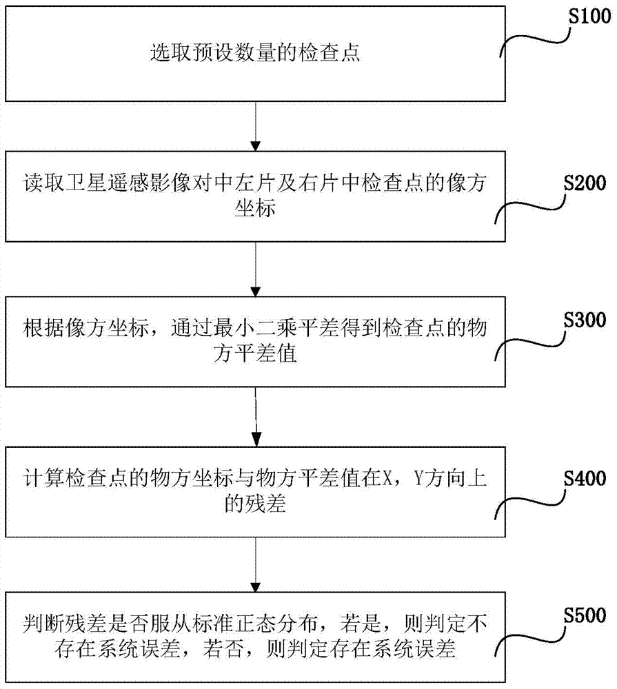
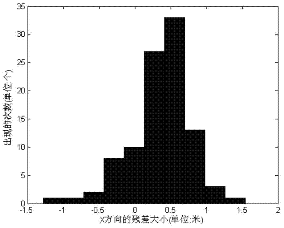
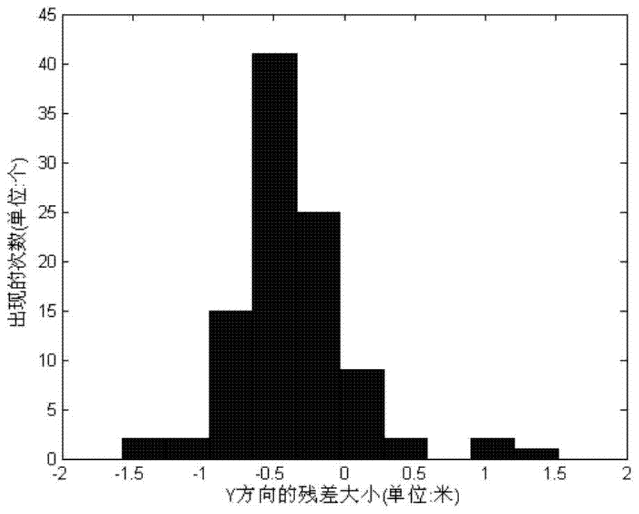
[0042] The method for judging the error of the topographic map measurement system in the embodiment of the present invention, such as figure 1 shown, including the following steps:

[0043] S100, selecting a preset number of checkpoints. You can set the number of checkpoints by yourself, the more the number is, the more accurate the detection result will be.

[0044] For example, 99 checkpoints are selected in one embodiment of the present invention. It is better to distribute the detecti...


PUM


Abstract

The invention discloses a method and a system for judging errors of a topographic map surveying system. The method comprises the following steps: selecting a predetermined quantity of check points; reading image space coordinates of check points in a left satellite remote sensing image aligning piece and a right satellite remote sensing image aligning piece; obtaining object space difference values of the check points by the least square adjustment method according to the image space coordinates; calculating object space coordinates of the check points and residue errors of object space adjustment values in an X direction and a Y direction; and judging whether the residue errors are subjected to a standard normal distribution, if so, judging the system errors are not generated, and otherwise, judging the system errors are generated. By virtue of the method and the system, the system errors are judged after block adjustment is calculated; the great difference in the final topographic map caused by the system errors can be judged; the errors are detected in intermediate steps, so that the measurement operations of a plurality of subsequent steps are eliminated; the manpower and material resources are saved.

Description

technical field [0001] The invention relates to the field of surveying and mapping, in particular to a method and system for judging the error of a topographic map measurement system. Background technique [0002] At present, in the field of photogrammetry and remote sensing, the method of aerial photogrammetry mapping is the main means of producing and updating national basic scale topographic maps. Although aerial image mapping has a sound theoretical basis and a relatively mature production process, it has the following defects: (1) Due to the low aerial photography height when acquiring aerial images, the quality of aerial images is less affected by the atmosphere and terrain. Seriously, before taking aerial photography, it is necessary to investigate the climate, weather, terrain, etc. (2) Since the image size of the aerial camera is generally 23cm×23cm, affected by the height of the flight, it covers a small area, and the number of aerial images required for surveying...

Claims


Application Information

Patent Timeline
Patent Type & Authority Patents(China)
IPC IPC(8): G01C25/00
CPCG01C25/00
Inventor 虞欣杨伯钢
Owner BEIJING INST OF SURVEYING & MAPPING
Why Eureka
Try Eureka