Multi-data-source map download method

A multi-data source and map technology, applied in the GIS field, can solve problems such as no data, inability to keep geographic data casually, inability to directly use Internet online maps, etc.

Active Publication Date: 2016-01-27
NETPOSA TECH
View PDF6 Cites 10 Cited by
  • Summary
  • Abstract
  • Description
  • Claims
  • Application Information

AI Technical Summary

Problems solved by technology

[0002] With the increasing application of maps, the demand for map data is also increasing. However, data with accurate coordinates is a state secret, and individuals or companies without surveying and mapping qualifications cannot keep geographic data casually; on the other hand, the purchase price of geographic data Expensive. For projects that have not been officially purchased by users, purchasing data will increase project expenditures. Without data, the functions of map-based applications cannot be displayed
Based on this, map data has become a common bottleneck in the development of map applications
The network map data is encrypted, so there is no confidentiality problem. For projects that have not been implemented, or some map applications that only need a base map, the network map is the best choice. However, in many cases, the place where the project is applied It is not connected to the Internet, so you cannot directly use the Internet online map, so you must find a way to download the map to the local deployment
[0003] The existing map downloaders are basically paid, only the free download tool Daoge, there are some problems, such as using the form of data capture, relatively passive, slow download speed, can only download google maps, and often There will be missing data

Method used


Image

  • Multi-data-source map download method
  • Multi-data-source map download method

Examples


Embodiment Construction

[0020] The present invention will be further described below in conjunction with the accompanying drawings.

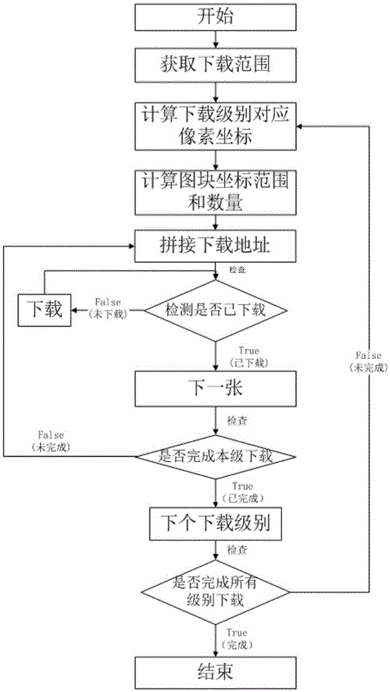
[0021] The invention provides a method for downloading multi-data source map cache slices. Before downloading, determine the type of online map to be downloaded: Baidu map, Google map or PGIS map (GIS for public security and police). Among them, the PGIS online map runs on the public security intranet, and the Baidu map or Google map runs on the Internet. It is necessary to ensure the type of network where the map is downloaded to keep the network unblocked. figure 1 Shown is the general flow of the multi-data source map cache tile download method:

[0022] First, obtain the download level and download range. After setting the download level, browse the map to the initial level range that needs to be downloaded, and start the task to start the download. The first is to obtain the coordinate range of the download. This range is a rectangular frame, select the corner...


PUM


Abstract

The present invention provides a multi-data-source map download method. The multi-data-source map download method comprises: acquiring map coordinates of a downloading range; calculating pixel coordinates corresponding to a download level according to the map coordinates ; calculating a tile coordinate range and the number of slices (tiles) that needs to be downloaded according to the pixel coordinates; and splicing into a complete cache slice download address. Meanwhile, provided is a method for calculating the pixel coordinates corresponding to the download level according to the map coordinates while downloading a PGIS map cache slice by using the multi-data-source map download method. By the multi-data-source map download method, a WebGIS cache slice address is reversely analyzed and a map cache slice is downloaded to a local; and the method is suitable for providing base map base data and a download method for Web GIS application development.

Description

technical field [0001] The invention relates to the technical field of GIS, and is suitable for providing basic map base map data and a downloading method for WebGIS application development. Background technique [0002] With the increasing application of maps, the demand for map data is also increasing. However, data with accurate coordinates is a state secret, and individuals or companies without surveying and mapping qualifications cannot keep geographic data casually; on the other hand, the purchase price of geographic data Expensive. For projects that have not been officially purchased by users, the purchase of data will increase the expenditure of the project. Without data, the functions of map-based applications cannot be displayed. Based on this, map data has become a common bottleneck in the development of map applications. The network map data is encrypted, so there is no confidentiality problem. For projects that have not been implemented, or some map application...

Claims


Application Information

Patent Timeline
Patent Type & Authority Applications(China)
IPC IPC(8): G06F17/30
CPCG06F16/29
Inventor 程飞郑建明
Owner NETPOSA TECH
Why Eureka
Try Eureka