Optical satellite image time-varying error calibrating method and system based on multiple calibration fields

An optical satellite and multi-calibration field technology, applied in the field of remote sensing image processing, can solve the problems of time-varying error calibration method and calibration model construction of optical remote sensing satellite image system

Active Publication Date: 2016-04-20
WUHAN UNIV
View PDF3 Cites 6 Cited by
  • Summary
  • Abstract
  • Description
  • Claims
  • Application Information

AI Technical Summary

Problems solved by technology

[0004] The present invention mainly solves the problems of the calibration method of the time-varying error of the optical remote sensing satellite image system and the construction of the calibration model

Method used


Image

  • Optical satellite image time-varying error calibrating method and system based on multiple calibration fields
  • Optical satellite image time-varying error calibrating method and system based on multiple calibration fields
  • Optical satellite image time-varying error calibrating method and system based on multiple calibration fields

Examples


Embodiment Construction

[0039] The specific implementation of the present invention will be described in detail below in conjunction with the accompanying drawings and examples.

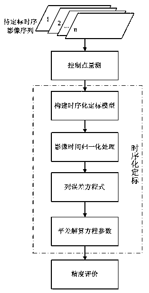
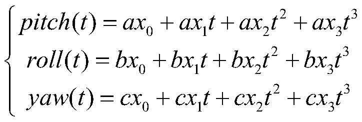
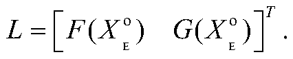
[0040]The external error of the optical remote sensing satellite image system mainly comes from the camera installation angle error, which is manifested as a drift error in the vertical and along-track directions on the image, and the error on the same-track image is almost the same, and the error presents a certain timing. In order to compensate the time-varying error of the optical remote sensing satellite system, the present invention proposes a time-varying error calibration and modeling method of the optical remote sensing satellite image system based on multiple calibration fields, and introduces time factors on the basis of a strict geometric imaging model to establish a time series The calibration model, through the regular long-term calibration of the optical remote sensing satellite system, simulates the law of the...


PUM


Abstract

The invention provides an optical satellite image time-varying error calibrating method and system based on multiple calibration fields. In order to accurately calibrate external parameters of an optical remote sensing satellite system, time parameters are considered when a calibration model is built, and a polynomial relationship between an installation angle and normalized time parameters is built and guided into a satellite image strict geometric imaging model to build a timing sequence calibration model; according to a certain time sequence, an image covering the multiple calibration fields is selected as the image to be calibrated for control point measurement; the time of the selected image is normalized; according to the timing sequence calibration model, an error equation is built, and a remote sensing image is calibrated through the built model. The method is feasible and effective, and an adjustment calculating result is stable and reliable.

Description

technical field [0001] The invention belongs to the field of remote sensing image processing, and relates to a time-varying error calibration method and system for optical satellite images based on multiple calibration fields. Background technique [0002] Calibration of optical remote sensing satellite images is the basis of geometric processing of optical remote sensing images and the premise of utilizing the geometric performance of remote sensing images. The model basis of optical remote sensing satellite image calibration is the geometric orientation model. The geometric orientation model mainly includes strict geometric imaging model and rational polynomial model (RPC model). The RPC model has the characteristics of uniform form and simple use, but it can also hide The key parameter information of the satellite load is not conducive to introducing time parameters into the model, while the camera installation angle parameter in the strict geometric imaging model is domi...

Claims


Application Information

Patent Timeline
Patent Type & Authority Applications(China)
IPC IPC(8): G01S7/497
CPCG01S7/497
Inventor 王密杨博龙小祥李德仁
Owner WUHAN UNIV
Why Eureka
Try Eureka