A Network Synchronization and Transformation Method for Geographic Wiring Diagram

A technology of geographic wiring diagram and conversion method, which is applied in the field of network synchronization and conversion of geographical wiring diagram, can solve the problems that the system cannot provide timely feedback, data cannot be exchanged and shared effectively, and the collaborative interaction and operational characteristics of the platform cannot be fully displayed. The effect of ensuring timely and reducing user waiting time

Active Publication Date: 2019-05-21
STATE GRID CORP OF CHINA +2
View PDF6 Cites 0 Cited by
  • Summary
  • Abstract
  • Description
  • Claims
  • Application Information

AI Technical Summary

Problems solved by technology

When performing multi-person collaborative computing, only a centralized office method can be used, and each user operates independently, the system cannot provide timely feedback, data cannot be effectively exchanged and shared, and the collaborative interaction and operating characteristics of the platform cannot be fully displayed

Method used


Image

  • A Network Synchronization and Transformation Method for Geographic Wiring Diagram
  • A Network Synchronization and Transformation Method for Geographic Wiring Diagram
  • A Network Synchronization and Transformation Method for Geographic Wiring Diagram

Examples


Embodiment 1

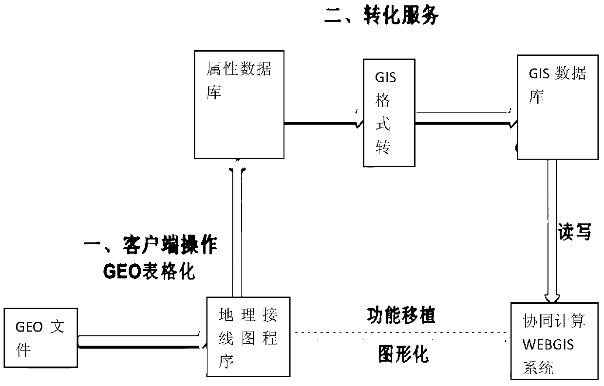
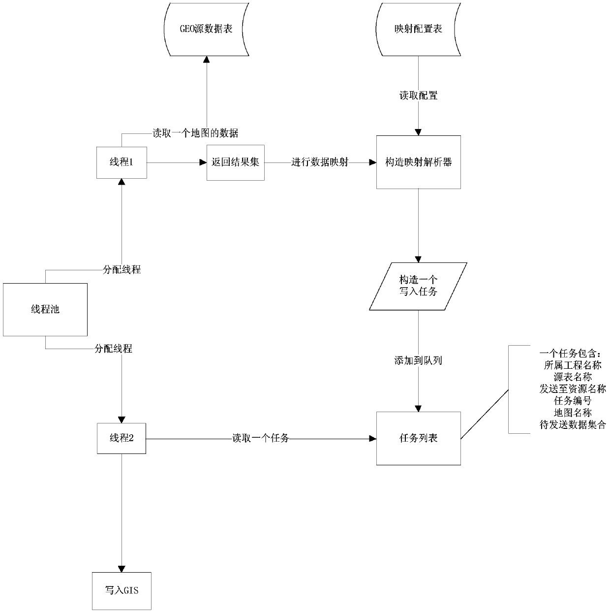
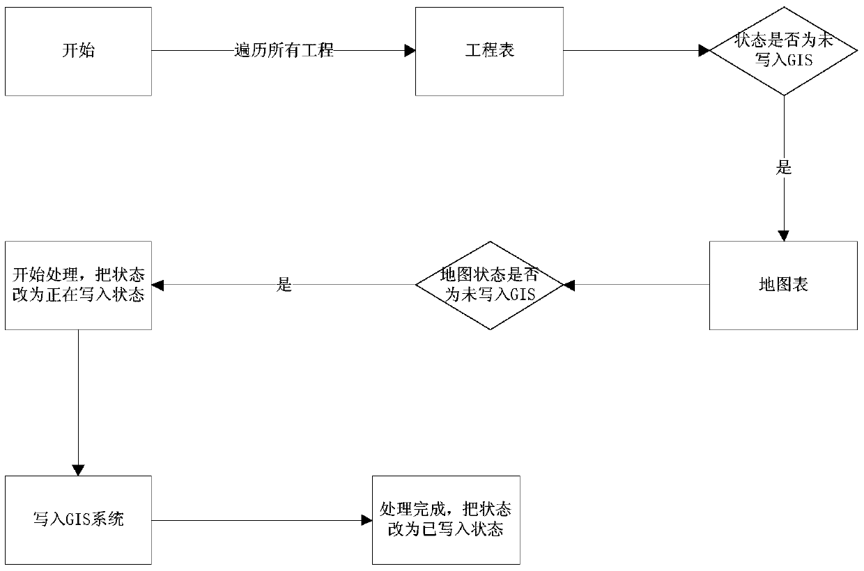
[0039] Such as figure 1 As shown in -4, the invention of this example is a geographical wiring diagram networked synchronization and conversion method, and the method includes the following steps:

[0040] GEO file tabularization

[0041] Provide a data source for GIS data conversion, use the collaborative version geographic wiring diagram program to edit and save GEO files, and then convert the original binary GEO format geographic wiring diagram files into tables and persist them to the database.

[0042] After tabulation, the following GEO tables are mainly generated

[0043]G_DATALINE: The internal lines of the connection lines between the plant and the plant, including AC lines, DC lines, phase-shifting transformers, three sides of three-winding transformers, two sides of three-winding transformers, one side of three-winding transformers, two-winding transformers, capacitors in series. This line is not displayed on the web, it is only used for power flow calculation. ...


PUM


Abstract

The invention relates to a networked synchronization and conversion method for geographical wiring diagrams. The method comprises following steps: charting GEO files of a client to a GEO chart and persisting the client GEO to a database; converting a basic list of the database with charted GEO files to data of a GIS format, building threads with each responsible for reading data of the GEO chart to be packed into one task placement array and others responsible for reading tasks in arrays and persisting data according to the GIS format to the database according to conversion mapping relations. The networked synchronization and conversion method for geographical wiring diagrams has following beneficial effects: the problem arising from conversion of data formats between the client and a browser side is solved; the reading standard of a WEBGIS spatial data engine of a data structure can be satisfied so that the browser side can use the client FEO; a WEB geographic map system is used for monitoring the client GEO and timely synchronizing the result of the client and synchronously updating the data of the client and the browser side; and the networked synchronization and conversion of geographical wiring diagrams are achieved.

Description

Technical field: [0001] The invention relates to a networked synchronization and conversion method, in particular to a networked synchronization and conversion method of a geographic wiring diagram. Background technique: [0002] In order to ensure the rapid and stable development of the power grid, it is necessary to carry out grid planning in a timely and effective manner, and it is not only an important link, but also a complex system engineering. The domestic power grid planning software mainly includes "PSASP Graphical Model Integration Platform" ( PSASP 7.0), etc. These softwares have improved the level of power grid planning and effectively reduced the labor intensity of planners. The PSASP7.0 system is a desktop application built on the basis of local databases and GEO files. Geographical wiring diagram, using graphical tools to maintain power grid equipment, adjust model parameters, arrange and debug operation modes, support power flow, temporary stability, static ...

Claims


Application Information

Patent Timeline
Patent Type & Authority Patents(China)
IPC IPC(8): G06F16/29
Inventor 李勤新刘琳臧主峰孙谊媊于永军翟媛媛陈勇潘志敏祁晓笑秦艳辉孙斌罗忠游
Owner STATE GRID CORP OF CHINA
Why Eureka
Try Eureka