A Coupling Simulation Method of Distributed Watershed Water-sediment Process

An analog method and distributed technology, applied in special data processing applications, instruments, electrical digital data processing, etc., can solve problems such as huge, large amount of calculation, and failure to meet requirements

Active Publication Date: 2018-07-20
CHINA INST OF WATER RESOURCES & HYDROPOWER RES
View PDF1 Cites 3 Cited by
  • Summary
  • Abstract
  • Description
  • Claims
  • Application Information

AI Technical Summary

Problems solved by technology

Therefore, the above-mentioned empirical method for calculating the water-sediment process does not consider the specific physical mechanism of the water-sediment process, and the time and space scales are large, which is difficult to meet the current needs of regional water and soil conservation management.
[0006] At the same time, due to the huge calculation amount of the water and sediment process in the watershed, it often requires huge computer hardware resources to realize the calculation, and even fails to meet the requirements. Therefore, the calculation based on the DEM grid requires a large amount of calculation in most cases. Calculations of water-sediment processes in watersheds are time-consuming

Method used


Image

  • A Coupling Simulation Method of Distributed Watershed Water-sediment Process
  • A Coupling Simulation Method of Distributed Watershed Water-sediment Process
  • A Coupling Simulation Method of Distributed Watershed Water-sediment Process

Examples


Embodiment 1

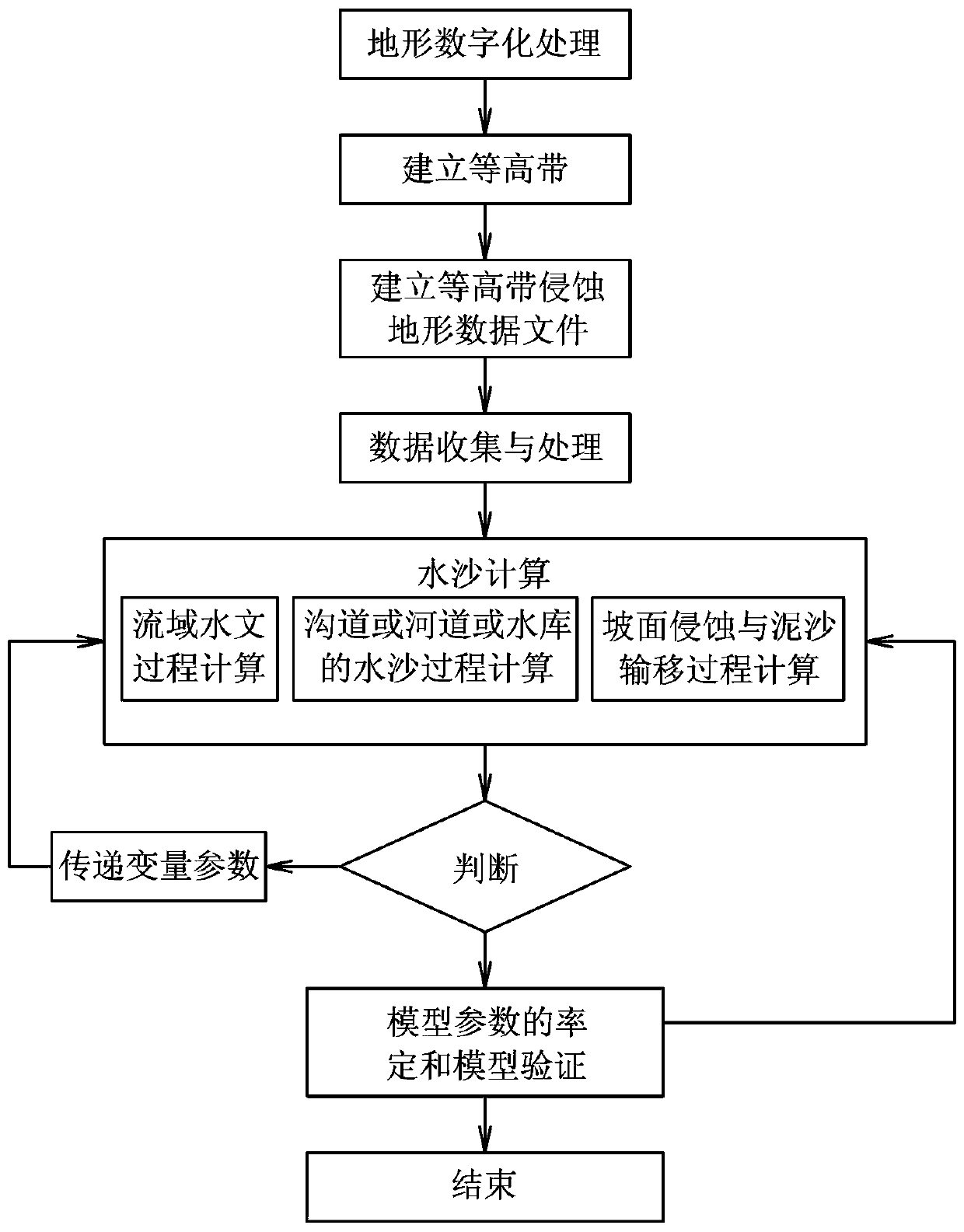
[0081] This embodiment is a method for coupling simulation of water and sediment processes in distributed watersheds. In this example, based on the process-based hydrological simulation, through the systematic identification of the coupling relationship between topographic features and hydrodynamic features, the establishment of soil erosion based on terrain "surface (sheet) erosion - rill erosion - shallow gully erosion - gully erosion" The simulation method of soil erosion and sediment transport process is based on the chain as the platform and the typical hydrodynamic conditions are "thin-layer water flow-stream flow". In this embodiment, firstly, the topological relationship of the slope calculation unit and the confluence channel network are formed by processing the DEM data, and then this is the platform for hydrometeorology, water and soil conservation measures (water and soil conservation forest grass, terraced fields, horizontal ditches, fish scale pits), land Use, te...

Embodiment 2

[0165] This embodiment is an improvement of the first embodiment, and is a refinement of the first embodiment on the calculation of evapotranspiration. The evapotranspiration calculation described in this embodiment:

[0166] The evapotranspiration within the calculation unit (within the contour zone) includes the evaporation from the wet leaf surface of vegetation (vegetation intercepted water), water area, soil, urban ground surface, urban buildings, etc., and the transpiration from dry vegetation leaf surface. The average evapotranspiration model of the calculation unit is calculated by the following formula:

[0167]

[0168] In the formula,F W , F U , F SV , F IR , F NI are the area ratios (%) of water area, impermeable water area, bare land-vegetation area, irrigated farmland and non-irrigated farmland in the calculation unit; E W , E U , E SV , E IR , E NI They are the evaporation or evapotranspiration of the water area, impermeable water area, bar...

Embodiment 3

[0207] This embodiment is an improvement of the above embodiment, and is a refinement of the above embodiment regarding infiltration calculation. The infiltration calculation described in this embodiment uses the Green-Ampt vertical one-dimensional infiltration model to simulate rainfall infiltration and over-seepage slope runoff, and the general Green-Ampt model for calculation.

[0208] When the infiltration wetting front reaches the mth soil layer, the infiltration capacity is calculated by the following formula:

[0209] (twenty four)

[0210] In the formula, f is the infiltration capacity; F is the cumulative infiltration; km, Am-1, and Bm-1 are described later. The calculation method of cumulative infiltration F depends on whether there is water accumulation on the ground surface.

[0211] If the ground surface continues to accumulate water since the infiltration wetting front enters the m-1th soil layer, then the cumulative infiltration amount is calculated by form...


PUM


Abstract

The invention relates to a coupling simulation method of a flow and sediment process of a distributed watershed. The method comprises the steps of digital terrain processing, building of a contour strip, building of a contour strip erosion landform data file, data collecting and processing, watershed hydrological process computation, slope erosion and sediment transport process computation, flow and sediment process computation of a channel or a river or a reservoir, judgment, variable parameter transferring, model parameter calibration and model validation, and ending. According to the coupling simulation method, the contour strip is taken as a computing platform for the slope scale, and the real flow and sediment physical process of a slope is taken as a picture, so that the coupling simulation computing capability for rainfall-runoff and erosion-sediment processes of the contour strip slope is achieved; the computational accuracy is ensured on the premise of reducing the computing amount; and the flow and sediment process of the slope with any grid scale is effectively reduced and predicted. Compared with the prior art, the coupling simulation method has the advantages that the terrain adaptability and the scale adaptability are achieved by taking the contour strip as a basic computing unit; meanwhile, deeper recognition of the law of the flow and sediment process of the slope can be achieved on the basis of physical flow and sediment process simulation of the slope and a more complicated practical application is supported.

Description

technical field [0001] The invention relates to a distributed river basin water-sediment process coupling simulation method, is a hydrological sediment process calculation method, and is a hydrological sediment process simulation calculation method using computer technology. Background technique [0002] The water-sediment process of the watershed will ultimately be attributed to the water-sediment process of slopes and rivers. The slope water and sediment process is a complex collection of multiple processes, including rainfall, vegetation canopy interception, surface cover interception, surface runoff, soil infiltration, slope confluence, river channel confluence, and reservoir water processes, while associated processes include raindrops Splash erosion, thin layer water flow erosion, channel water flow erosion, gravity erosion, and sediment transport and deposition processes. [0003] Most of the existing river basin water and sediment process simulations are empirical m...

Claims


Application Information

Patent Timeline
Patent Type & Authority Patents(China)
IPC IPC(8): G06F17/50
CPCG06F30/20
Inventor 龚家国王浩贾仰文周祖昊刘佳嘉王英牛存稳
Owner CHINA INST OF WATER RESOURCES & HYDROPOWER RES
Why Eureka
Try Eureka