Method and device for determining ground surface temperature by utilizing remote sensing data of FY-3 meteorological satellite of China

A satellite remote sensing data, Fengyun-3 technology, applied in the field of remote sensing quantitative inversion, can solve the complex problems of surface temperature inversion

Inactive Publication Date: 2017-05-31
INST OF GEOGRAPHICAL SCI & NATURAL RESOURCE RES CAS
View PDF4 Cites 17 Cited by
  • Summary
  • Abstract
  • Description
  • Claims
  • Application Information

AI Technical Summary

Problems solved by technology

The superposition of these several processes makes the inversion of surface temperature more complicated

Method used


Image

  • Method and device for determining ground surface temperature by utilizing remote sensing data of FY-3 meteorological satellite of China
  • Method and device for determining ground surface temperature by utilizing remote sensing data of FY-3 meteorological satellite of China
  • Method and device for determining ground surface temperature by utilizing remote sensing data of FY-3 meteorological satellite of China

Examples


specific Embodiment

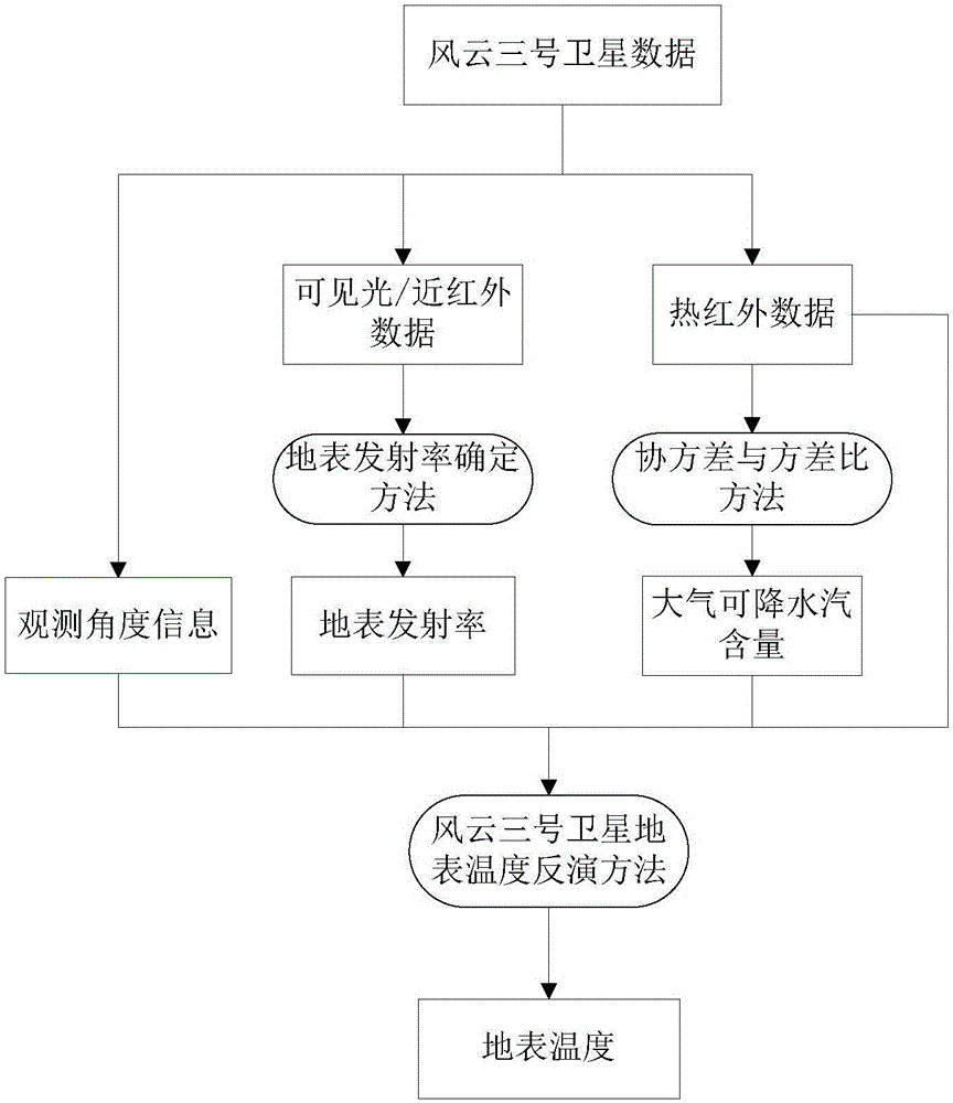
[0053] Such as figure 1 Shown, specific embodiment of the present invention is as follows:

[0054] A method for determining the surface temperature using the remote sensing data of the China Fengyun-3 satellite, the implementation steps are as follows:

[0055] Step (A), using the visible light and near-infrared observation data of Fengyun-3 satellite to determine the surface emissivity, the implementation method is as follows:
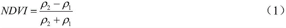
[0056] A1. Calculate the NDVI values ​​of all pixels in a scene image according to formula (1);

[0057] A2. When the NDVI value of the pixel in the image satisfies NDVI<0.2, calculate the surface emissivity values ​​of the 4th and 5th channels of Fengyun-3 satellite in the bare soil area according to formula (2) and formula (3) respectively;

[0058] A3. When the NDVI value of the pixel in the image satisfies NDVI>0.5, calculate the surface emissivity values ​​of the 4th and 5th channels of the Fengyun-3 satellite in the vegetation area according ...


PUM


Abstract

The invention discloses a method and device for determining ground surface temperature by utilizing remote sensing data of FY-3 meteorological satellite of China. The method comprises the following steps of: (A) obtaining a ground surface emissivity by utilizing visible light and near-infrared channel data of the FY-3 meteorological satellite of China and combining a developmental ground surface emissivity determination method; (B) determining an atmosphere precipitable water content by utilizing thermal infrared channel data of the FY-3 meteorological satellite of China and combining a developmental covariance to variance ratio; and (C) directly inverting the ground surface temperature from the thermal infrared channel data observed by the FY-3 meteorological satellite by utilizing the ground surface emissivity obtained in the step (A) and the atmosphere precipitable water content obtained in the step (B) and combining a developmental ground surface temperature remote sensing inversion method. According to the method and device disclosed by the invention, the quantitative remote sensing inversion carried out on the ground surface temperature through data of the FY-3 meteorological satellite of China is realized.

Description

technical field [0001] The invention belongs to the technical field of remote sensing quantitative inversion, in particular to a method and a device for determining the surface temperature by using the remote sensing data of China Fengyun-3 satellite. Background technique [0002] Surface temperature plays a very important role in the process of land-atmosphere interaction. It is one of the key parameters in the study of global change. It is of great significance to the research of hydrology, ecology, environment and biogeochemistry. Calculation of thermal inertia and other aspects also have important application value. Quantitative remote sensing inversion of surface temperature plays a very important role in promoting drought forecasting and crop water shortage research, crop yield estimation, numerical weather prediction, global climate change, and global carbon balance. [0003] Fengyun-3 (FY-3) meteorological satellite is a new generation of polar-orbiting meteorologic...

Claims


Application Information

Patent Timeline
Patent Type & Authority Applications(China)
IPC IPC(8): G06K9/00G01J5/00
CPCG01J5/007G06V20/13
Inventor 唐伯惠
Owner INST OF GEOGRAPHICAL SCI & NATURAL RESOURCE RES CAS
Why Eureka
Try Eureka