Unmanned aerial vehicle positioning method for forest resource sample-plot survey

A positioning method and technology of forest resources, which is applied in the field of UAV positioning in the survey of forest resource plots, can solve the problems of unobvious corner piles in the southwest corner, troubles in forest resource sample plot investigation, and weak signal corner piles, etc.

Inactive Publication Date: 2017-07-18
FUJIAN AGRI & FORESTRY UNIV
View PDF7 Cites 2 Cited by
  • Summary
  • Abstract
  • Description
  • Claims
  • Application Information

AI Technical Summary

Problems solved by technology

[0003] At present, GPS navigation technology is usually used to find the southwest corner piles of the sample plots. Investigators mainly use the navigation and positioning functions of handheld GPS. However, the corner piles in the southwest corner of the sample plots are not obvious due to the growth of trees and the special environmental factors in the forest area. Including tree canopy, canopy density, terrain conditions, etc., the GPS signal is blocked, so the handheld GPS positioning is not accurate, and it is impossible to quickly and conveniently locate the corner pile in the southwest corner of the plot
At present, widely used positioning instruments include total station, theodolite, handheld GPS, etc. Although these devices can perform effective positioning, they are affected by the shortest line of sight, weak signal, and corner piles being blocked by trees when surveying forest resource plots. On the contrary, it cannot play its role, and it also requires investigators to conduct manual searches, which has brought some troubles to the survey of forest resource sample plots. Due to the needs of investigation and research, rapid positioning is particularly important

Method used


Image

  • Unmanned aerial vehicle positioning method for forest resource sample-plot survey
  • Unmanned aerial vehicle positioning method for forest resource sample-plot survey
  • Unmanned aerial vehicle positioning method for forest resource sample-plot survey

Examples


Embodiment Construction

[0027] The technical solutions of the present invention will be further described in detail below in conjunction with specific embodiments.

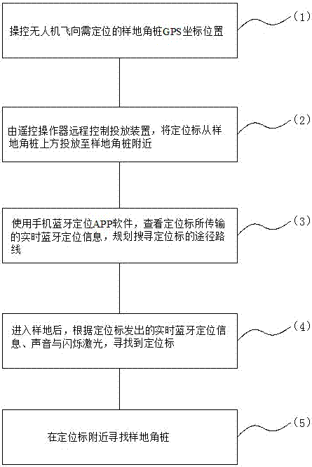
[0028] The flow chart of the present invention is as figure 1 As shown, the specific implementation process is divided into three stages, which are the pre-preparation stage, the positioning and delivery stage, and the search and positioning stage.

[0029] Preparatory stage

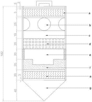
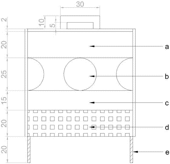
[0030] Fix the delivery device on the table below the drone;

[0031] Turn on the power switch of the locator, start it and check whether the sound guidance, flashing guidance, and Bluetooth APP guidance functions of the locator can work normally, that is, whether the broadcasting speaker can broadcast normally, whether the flashlight can flash normally, and whether the Bluetooth locator can communicate with the mobile APP normally. The software is normal and stable;

[0032] Fix the positioning mark on the fixed hook of the delivery device, use the remote contr...


PUM


Abstract

The invention provides an unmanned aerial vehicle positioning method for forest resource sample-plot survey. The method comprises the following steps of (1), performing controlling on an unmanned aerial vehicle for making the unmanned aerial vehicle fly to a to-be-positioned sample-plot corner pile GPS coordinate position; (2), performing remote controlling on a launching device by a remote control operator, and launching a positioning mark from a position above a sample-plot corner pile to the position next to the sample-plot corner pile; (3), performing real-time transmission of Bluetooth positioning information by a Bluetooth signal positioning device in an inner component of the positioning mark, checking the real-time Bluetooth positioning information transmitted from the positioning mark by means of mobile phone Bluetooth positioning APP software, and planning a route path for searching the positioning mark; (4), after entering a sample plot, searching the positioning mark according to the real-time Bluetooth positioning information, sound and flashing laser transmitted from the positioning mark; and (5), searching the sample-plot corner pile at periphery of the positioning mark. The unmanned aerial vehicle positioning method aims to quickly and conveniently determine position of the sample-plot corner pile.

Description

technical field [0001] The invention relates to a positioning method for an unmanned aerial vehicle for surveying forest resource plots. Background technique [0002] Currently, the first and second types of national forest resources surveys are surveys of fixed plots. In the survey, it is first necessary to locate the fixed survey plots that have been laid out in the lush forest. According to the National Forest Resources Survey Standards, four corner stakes were set at the four corners of the fixed survey plot, and the southwest corner stakes recorded accurate GPS coordinates when the plot was laid out. Therefore, to conduct the first and second types of forest resource surveys, the specific location of the fixed survey sample plot must first be located. To locate the specific location of the fixed survey sample plot, the specific location of the southwest corner post should be located based on the GPS coordinates of the corner post at the southwest corner of the sample pl...

Claims


Application Information

Patent Timeline
Patent Type & Authority Applications(China)
IPC IPC(8): G05D1/12
CPCG05D1/12
Inventor 余坤勇刘健张佳奇陈樟昊姚雄
Owner FUJIAN AGRI & FORESTRY UNIV
Why Eureka
Try Eureka