Passive coherent location radar-based unmanned aerial vehicle real-time monitoring system and method

A technology of external radiation source radar and real-time monitoring system, applied in radio wave measurement system, utilization of re-radiation, reflection/re-radiation of radio waves, etc. Or upgrade difficulties, disrupt airport flight order, etc., to achieve effective monitoring and tracking capabilities, strong maintainability, and good low-altitude coverage.

Active Publication Date: 2017-07-21
WUHAN UNIV
View PDF11 Cites 35 Cited by
  • Summary
  • Abstract
  • Description
  • Claims
  • Application Information

AI Technical Summary

Benefits of technology

This technology saves time by reducing interference from other signals while still being able to detect target movements accurately with minimal impact on human health or damage caused due to lightning strikes. It uses digitized video images captured at different angles around ground level that can be processed quickly without generating excessively large amounts of noise. Additionally, it provides powerful tools like GPGPU (Graphic Processing Unit) hardware accelerators and CPUs to process complex calculations faster than traditional methods such as radar systems. Overall, this technology helps improve efficiency and accuracy during surveillance tasks.

Problems solved by technology

The technical issue addressed in this patented paper relates to surveillance systems where there may exist suspicious dronies without being detected due to factors like illegal radioactive materials. Current techniques involve expensive and complex cameras equipped outside government buildings, while alternative technologies including remote sensory radar provide an effective solution.

Method used


Image

  • Passive coherent location radar-based unmanned aerial vehicle real-time monitoring system and method
  • Passive coherent location radar-based unmanned aerial vehicle real-time monitoring system and method
  • Passive coherent location radar-based unmanned aerial vehicle real-time monitoring system and method

Examples


Embodiment Construction

[0055] In order to facilitate those of ordinary skill in the art to understand and implement the present invention, the present invention will be described in further detail below in conjunction with the accompanying drawings and embodiments. It should be understood that the implementation examples described here are only for illustration and explanation of the present invention, and are not intended to limit this invention.

[0056] In recent years, GPU has become the first choice for low-cost external radiation source radar real-time signal processing solutions due to its extremely high cost performance, powerful floating-point calculation and parallel processing capabilities. Currently, GPU-based general computing programming models mainly include CUDA, OpenCL, DirectCompute, AMD APP and Brook GPU. Among them, CUDA based on C language programming is the most mature general-purpose computing solution with the largest market share. It has the advantages of low cost, simple st...


PUM


Abstract

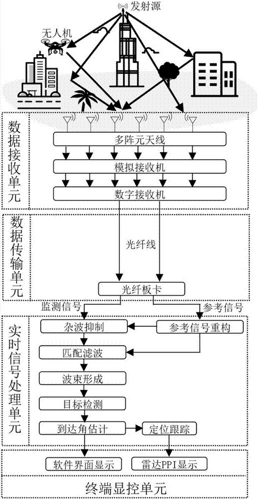
The invention discloses a passive coherent location radar-based unmanned aerial vehicle real-time monitoring system and method. The system comprises a data receiving unit, a data transmission unit, a real-time signal processing unit and a terminal display and control unit; the data receiving unit is used for receiving reference signals of a transmitting source and monitoring signals reflected by an unmanned aerial vehicle and inputting the signals to the real-time signal processing unit through the data transmission unit; and the data are processed by the real-time signal processing unit, so that the flight path of the unmanned aerial vehicle can be obtained and is displayed in real time on the terminal display and control unit. The passive coherent location radar-based unmanned aerial vehicle real-time monitoring system and method of the invention do not need frequency allocation, generate no electromagnetic pollution and can perform monitoring around the clock. The passive coherent location radar-based unmanned aerial vehicle real-time monitoring system and method have the advantages of high data processing speed, high data update rate, real-time monitoring, low development and maintenance cost and strong networking capacity.

Description


Claims


Application Information

Patent Timeline
Owner WUHAN UNIV
Why Eureka
Try Eureka