
Intersection vehicle queuing length estimating method using low-sampling-rate GPS (Global Positioning System) data

A technology of GPS data and queue length, applied in the field of intelligent transportation, can solve the problems of large hardware loss and high construction cost, and achieve the effect of saving construction

Active Publication Date: 2017-09-01
上海济达交通科技有限公司
View PDF5 Cites 30 Cited by
  • Summary
  • Abstract
  • Description
  • Claims
  • Application Information

AI Technical Summary

Problems solved by technology

[0006] In order to solve the problems of large hardware loss and high construction cost in the prior art, the present invention proposes a method for estimating the queuing length of vehicles at intersections using low-sampling rate GPS data, and uses the low-sampling rate vehicle GPS track data at intersections to perform Estimation of Queue Length of All Vehicles at Unsaturated Intersections

Method used


Image

  • Intersection vehicle queuing length estimating method using low-sampling-rate GPS (Global Positioning System) data
  • Intersection vehicle queuing length estimating method using low-sampling-rate GPS (Global Positioning System) data
  • Intersection vehicle queuing length estimating method using low-sampling-rate GPS (Global Positioning System) data

Examples


Embodiment 1

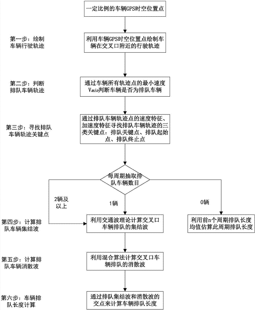
[0052] The present invention proposes a method for estimating the queuing length of vehicles at a non-saturated signal intersection using low sampling rate GPS track data, which is carried out according to the following steps:

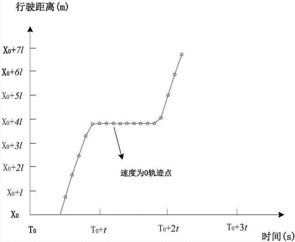
[0053] (1) Within the cycle time of an intersection, extract the GPS track data of vehicles at a certain ratio (5% to 20%) at any one of the entrances at the intersection, and make the cumulative driving distance of the extracted vehicles based on the cumulative driving distance of the vehicle distance curve;

[0054] (2) Exclude all track points in the track whose velocity is greater than V min The trajectory data of , and the remaining trajectory data is the vehicle trajectory data that experienced queuing in the cycle;

[0055] (3) For the extracted trajectory data of each vehicle, the slave speed is less than V min The key point of queuing is preliminarily judged in the point of , and the speed of vehicle i at the jth track point is set to be w...

Embodiment 2

[0068] In the present invention, when a vehicle passes through an intersection, if it is equipped with a smart phone or other positioning device that can record GPS track data, the information that can be recorded includes: user ID number, longitude, latitude, recording time, movement angle, speed and other information .

[0069] The present invention utilizes the space-time track points of vehicles passing through the intersection to estimate the vehicle queuing length of each entrance road at the intersection, and the specific method flow chart is as follows figure 1 shown. The specific method of each step is introduced in detail below.

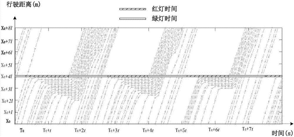
[0070] Step 1: Assuming that all vehicles passing through the intersection are equipped with mobile phones that can record GPS track data, extract the latitude and longitude information of vehicles at each time point, calculate the cumulative driving distance at each time point, and use the distance before the stop line at the intersection...


PUM


Abstract

The invention discloses an intersection vehicle queuing length estimating method using low-sampling-rate GPS (Global Positioning System) data. The method comprises the following steps: estimating an intersection vehicle queuing length by using low-sampling-rate GPS data to provide a basis for optimization of intersection signal timing, and estimating an intersection running state; finding a queuing starting point and a queuing terminating point of vehicles through track point speeds and acceleration features of the vehicles, estimating a queuing wave and a queuing dissipation wave through a traffic wave theory and a curve-fitting theory in conjunction with periodical red lamp starting and ending moments, and determining a vehicle queuing length of an intersection through the queuing wave and queuing dissipation wave. In the method, a possible queuing key point and a possible non-queuing key point are found by using the speed features of vehicle track points, the feature of an acceleration value of the possible queuing key point is analyzed, and the queuing starting point and the queuing terminating point are found through the feature of the acceleration value of the possible queuing key point.

Description

technical field [0001] The invention belongs to the field of intelligent transportation, and relates to a method for estimating the vehicle queuing length at an unsaturated intersection by using vehicle GPS track data with a low sampling rate. Background technique [0002] With the popularization and application of smart phones and various APPs, smart phone devices equipped with GPS can efficiently obtain the spatio-temporal location information of mobile phones, that is, trajectory data. Apps related to travel services have also become a common information platform for people's transportation and travel, providing convenience for people's travel, and some travel service APP software keeps recording the spatiotemporal location information of their vehicles in the background. How to use the high-frequency GPS vehicle spatio-temporal location information generated by smart phones to provide convenience for the development of the transportation industry has become the research ...

Claims


Application Information

Patent Timeline
Patent Type & Authority Applications(China)
IPC IPC(8): G08G1/065
CPCG08G1/065
Inventor 孙剑刘启远唐克双张磊陈晓芸
Owner 上海济达交通科技有限公司
Learn More