High-precision positioning method and system for protecting location privacy of users

A positioning method and high-precision technology, applied in the field of navigation and positioning, can solve the problems of user location privacy data protection and achieve the effect of protecting location privacy data

Active Publication Date: 2018-03-20
QIANXUN SPATIAL INTELLIGENCE INC
View PDF6 Cites 24 Cited by
  • Summary
  • Abstract
  • Description
  • Claims
  • Application Information

AI Technical Summary

Problems solved by technology

[0025] The invention provides a high-precision positioning method and system for protecting use

Method used


Image

  • High-precision positioning method and system for protecting location privacy of users
  • High-precision positioning method and system for protecting location privacy of users
  • High-precision positioning method and system for protecting location privacy of users

Examples


Embodiment Construction

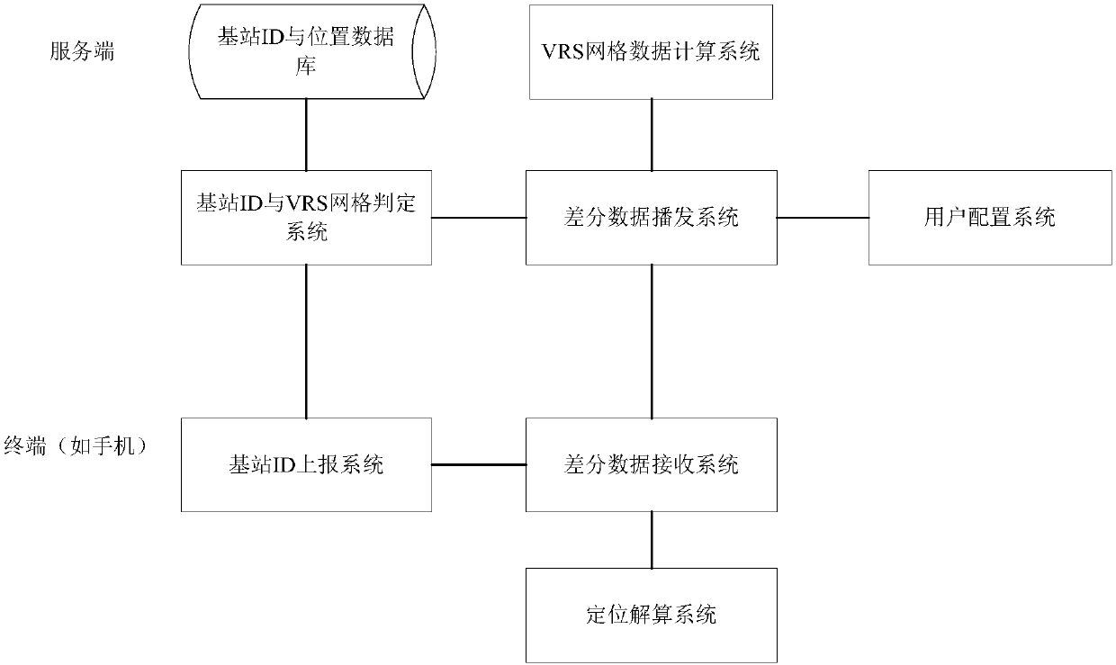
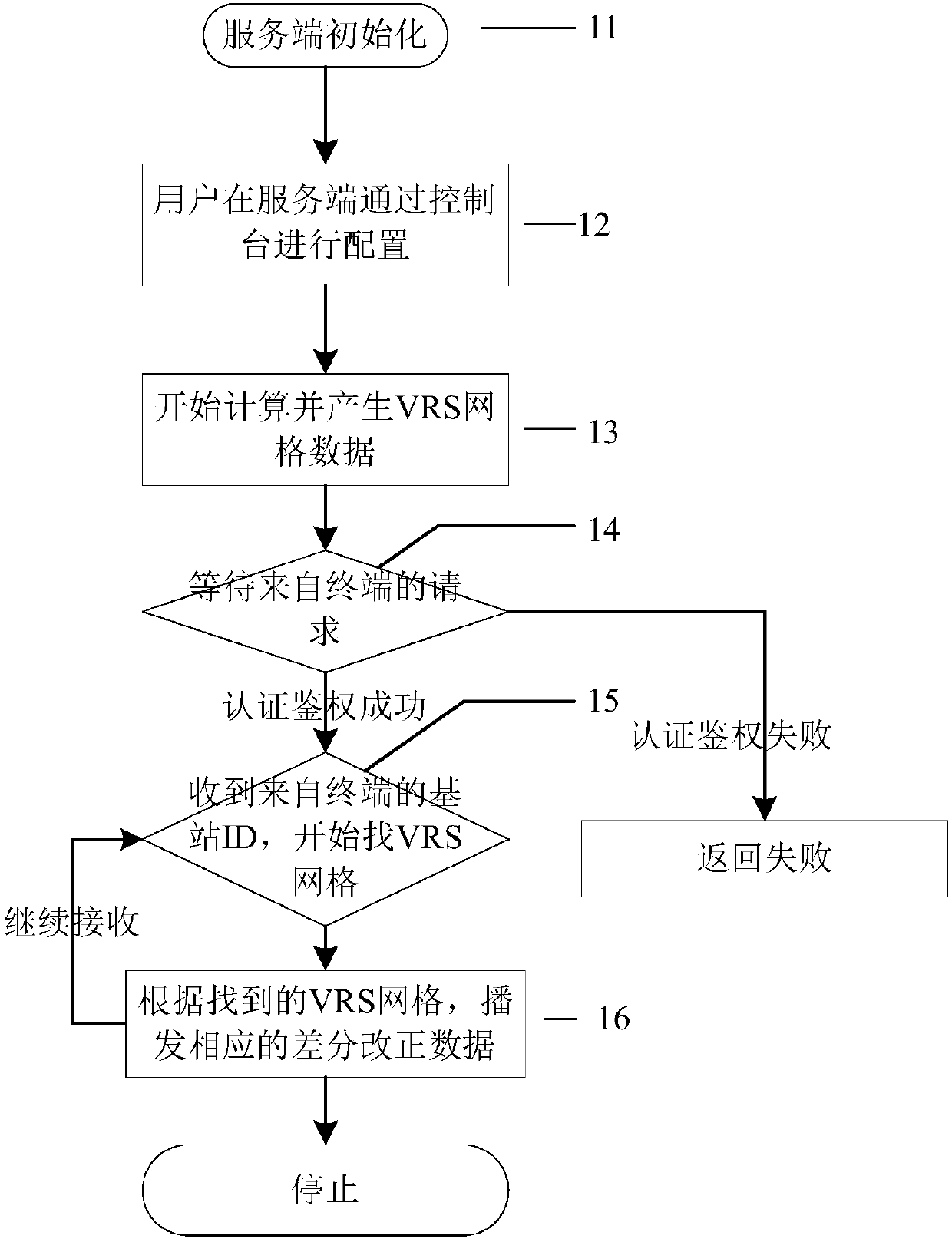
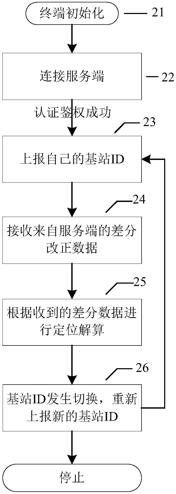
[0062] The present invention provides a high-precision positioning method that protects user location privacy:

[0063] 1. The terminal only reports the ID of the mobile communication base station, not the NMEA GGA data;

[0064] 2. The server pre-establishes a database corresponding to the ID of the mobile communication base station and the geographic location of the mobile communication base station;

[0065] 3. The server finds the geographic location of the mobile communication base station according to the mobile communication base station ID reported by the terminal;

[0066] 4. The server matches the corresponding virtual reference station grid according to the geographical location of the mobile communication base station;

[0067] 5. According to the found virtual reference station grid, broadcast the differential correction data corresponding to the grid to the terminal.

[0068] Note 1: Reporting the mobile communication base station ID requires a two-way interact...


PUM


Abstract

The invention provides a high-precision positioning method and system for protecting location privacy of users. The method includes the following steps: a terminal reports a mobile communication basestation ID to a server instead of reporting NMEA GGA data; the server establishes a corresponding relationship between the mobile communication base station ID and a location of a mobile communicationbase station in advance, and stores the corresponding relationship in a base station ID and location database; the server finds the location of the mobile communication base station according to themobile communication base station ID reported by the terminal; the server matches a corresponding virtual reference station grid according to the location of the mobile communication base station; andthe server broadcasts differential correction data corresponding to the virtual reference station grid to the terminal according to the matched virtual reference station grid. According to the high-precision positioning method and system provided by the invention, location privacy data of the users can be effectively protected technically.

Description

technical field [0001] The invention relates to the technical field of navigation and positioning, in particular to a high-precision positioning method and system for protecting user location privacy. Background technique [0002] Network RTK: Network RTK, also known as base station RTK, is a new technology established on the basis of conventional RTK and differential GPS. We usually establish multiple (generally three or more) GPS reference stations in an area to form a mesh coverage of the area, and calculate and broadcast based on one or more of these reference stations GPS correction information, so as to correct the positioning method of GPS users in the area in real time is called GPS network RTK, also known as multi-reference station RTK. [0003] VRS: Virtual Reference Stations virtual reference station. First set up a certain number of base stations in a certain area, the base station receives the satellite signal, and then transmits the information to the informa...

Claims


Application Information

Patent Timeline
IPC IPC(8): H04W4/02H04W12/06H04W64/00
CPCH04W4/02H04W12/06H04W64/00
Inventor 周睿
Owner QIANXUN SPATIAL INTELLIGENCE INC
Why Eureka
Try Eureka