Multistage graph clustering division method of residence place polygon

A polygon and graph clustering technology, applied in the field of geographic information science research, can solve problems such as application limitations, failure to obtain information mining, and insufficient consideration of polygon shape features and spatial relationships

Active Publication Date: 2018-04-13
CHINA UNIV OF GEOSCIENCES (WUHAN)
View PDF4 Cites 5 Cited by
  • Summary
  • Abstract
  • Description
  • Claims
  • Application Information

AI Technical Summary

Problems solved by technology

[0003] Polygons are different from one-dimensional point data. They have distinct geometric features, spatial relationships, and semantic attributes. Clustering and analysis of polygons using various metrics can provide a basis for deeper mining of data information. When performing cluster analysis, not only must choose a spatial clustering algorithm with excellent effect, but also select a suitable spatial similarity index to measure the similarity between polygons. Many existing cluster analysis algorithms simplify polygons into points, or It only considers the non-spatial attributes and simple geometric attributes of polygons, and does not fully consider the shape characteristics and spatial relationships of polygons, which limits its application.
[0004] Therefore, at present, in order to conduct an objective and reliable clustering effect analysis on the polygonal data information of residential areas, it is impossible to obtain deeper information mining only through the simplified one-dimensional point data.

Method used


Image

  • Multistage graph clustering division method of residence place polygon
  • Multistage graph clustering division method of residence place polygon
  • Multistage graph clustering division method of residence place polygon

Examples


Embodiment 1

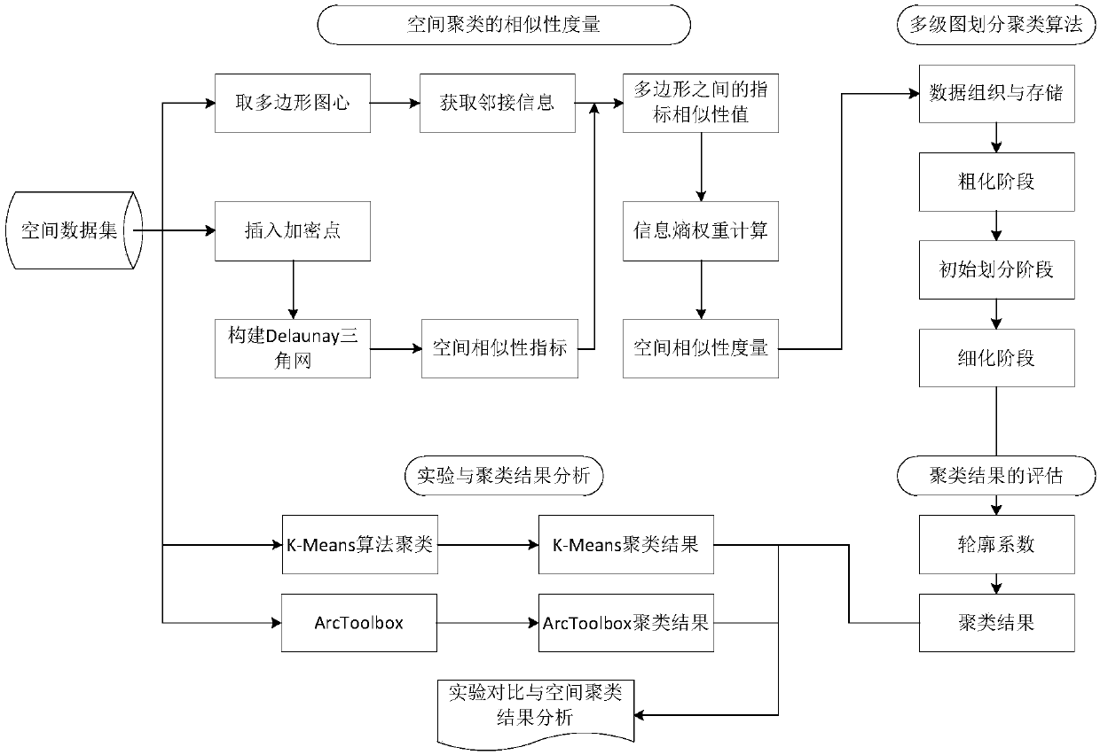
[0093] The present invention proposes a polygon clustering based on a multi-level graph partition algorithm, and uses the two-dimensional data of residents in Ontario, Canada—Waterloo Region—Walmot Township and Baden Region as experimental data. like figure 1 As shown, the whole process of this embodiment operates according to the following steps:

[0094] Step 1: acquisition of polygon adjacency information;

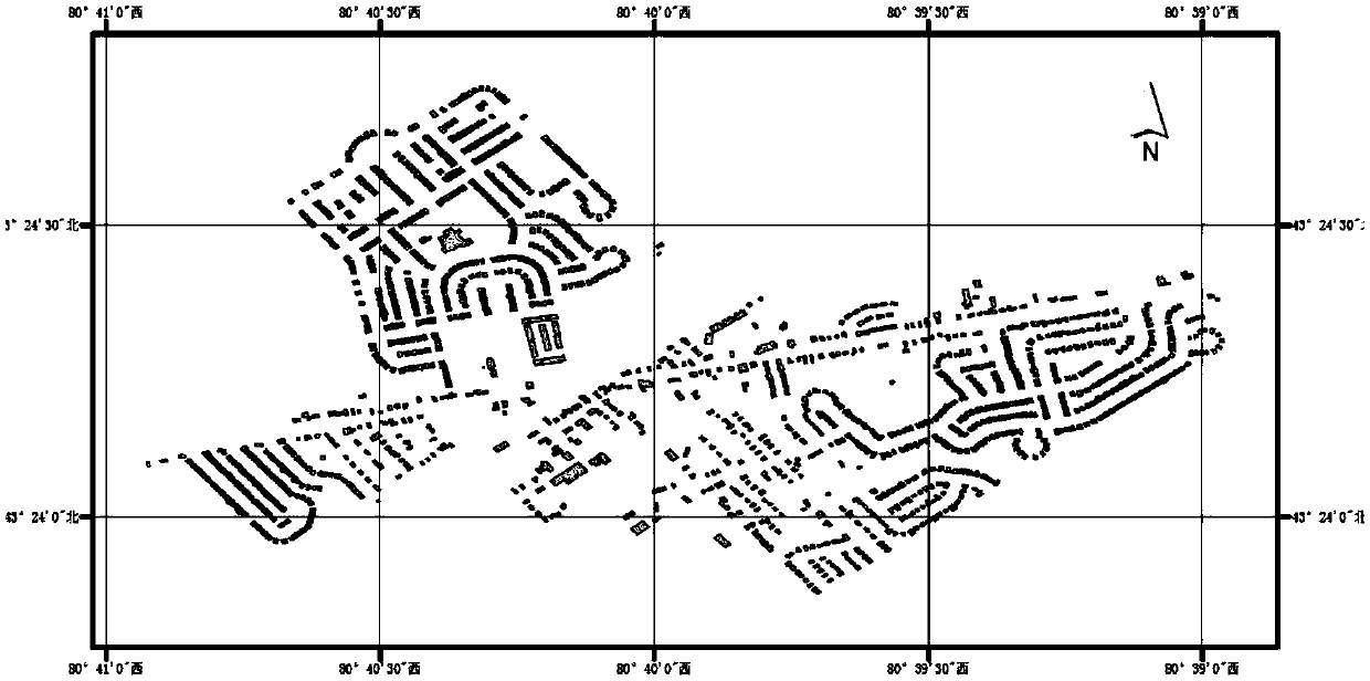
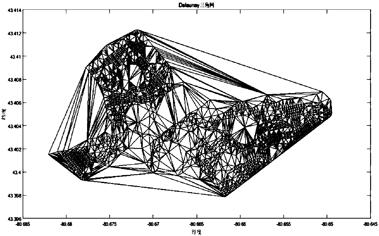
[0095] In order to measure the similarity between the polygonal buildings in the Baden area of ​​Canada, the present embodiment regards the building as a polygonal entity, the actual overlooking area of ​​the building is the area of ​​the polygon, and the actual perimeter of the building is the perimeter of the polygon. The collection of objects is a polygon dataset, and each polygon is identified with a unique identifier. like figure 2 and Figure 9 As shown, in this embodiment, we selected 1497 research objects in the Baden area as the research area. like imag...


PUM


Abstract

The invention provides a multistage graph clustering division method of a residence place polygon. The residence place polygon is used as an important face-shaped factor and has complex shape characteristics and attribute characteristics. In order to achieve the clustering analysis of the residence place polygon, based on the attribute characteristics of the polygon data, by combining the space cognition rule and characteristics of human cognition, adjacent information between polygons is firstly acquired; by combining similarity measure indexes like the shape narrow degree, the size, the concavity and convexity, the distance and the connectivity of five polygons, measurement is performed on the similarity between the polygons; then, normalization processing is performed on the similarityvalues and the weight of each index is determined; by use of a multistage graph division algorithm, clustering is performed on the polygons; and finally, analysis evaluation is performed on clusteringresults by use of profile coefficients. According to the invention, the obtained clustering results are quite objective and reliable.

Description

technical field [0001] The invention relates to the scientific research field of geographical information, in particular to a multi-level graph clustering and division method of residential polygons. Background technique [0002] In geographic information system, residential polygon is an important surface feature object, which has complex shape features and attribute features. The cluster analysis of polygons is a research hotspot and research difficulty in the fields of spatial data mining and geographic information science. [0003] Polygons are different from one-dimensional point data. They have distinct geometric features, spatial relationships, and semantic attributes. Clustering and analysis of polygons using various metrics can provide a basis for deeper mining of data information. When performing cluster analysis, not only must choose a spatial clustering algorithm with excellent effect, but also select a suitable spatial similarity index to measure the similarity...

Claims


Application Information

Patent Timeline
Patent Type & Authority Applications(China)
IPC IPC(8): G06K9/62G06T17/20
CPCG06T17/20G06F18/231G06F18/22
Inventor 陈占龙谢忠吴亮梁磊江宝得周林陶留锋马啸川刘建宇
Owner CHINA UNIV OF GEOSCIENCES (WUHAN)
Why Eureka
Try Eureka