Map system and navigation method based on image recognition
An image recognition and map technology, applied in the field of navigation, can solve problems such as difficult to distinguish things, lost direction, unable to use GPS, etc.
- Summary
- Abstract
- Description
- Claims
- Application Information
AI Technical Summary
Problems solved by technology
Method used
Image

Examples
Embodiment 1
[0093] In recent years, with the popularization of 4G networks, watching videos online through mobile clients has become very common. In the future, with the increase of network bandwidth and the development of video compression decoding technology, the solution of the present invention can be very conveniently applied to mobile clients.
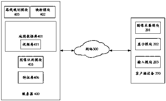
[0094] image 3 A specific implementation manner in which a user uses the map system of the present invention through a mobile client is shown, but the actual structure is not limited thereto.
[0095] In this embodiment, considering the computing capability and storage capability of the mobile client, both the storage and computing modules are set on the server side. In reality, part of the computing and storage tasks can be transferred to the mobile client according to the actual situation. Of course, it can also be completely transferred to the mobile client, if the computing and storage capabilities of the mobile client allow it.
[0...
Embodiment 2
[0100] With the development of intelligent robot technology, intelligent robots that can take pictures of customers and provide inquiry services already exist in high-end shopping malls. Most of these robots are mobile.
[0101] The inventor loads the map system of the present invention on these intelligent robots to realize the purpose of navigating through mobile query devices.
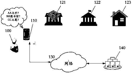
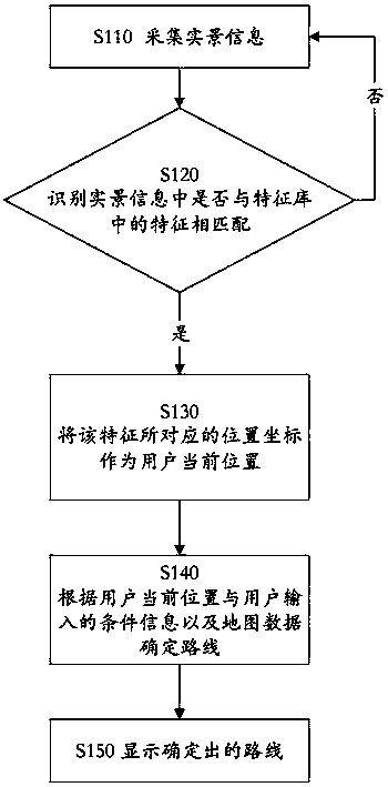
[0102] Figure 4 A schematic structural diagram of the query device 260 is shown. The image acquisition module 261 can be a camera, so that the mobile robot can confirm the current position. The feature library 264 and the map database 265 can be set inside the mobile robot according to the situation, or realize information interaction with the mobile robot through the network.
[0103] Since there is a corresponding relationship between the feature database 264 and the map database 265, after the image recognition, the position of the recognized landmark in the map can be confirmed, thereby real...
PUM
 Abstract
Description
Claims
Application Information
 - R&D Engineer
- R&D Manager
- IP Professional
- Industry Leading Data Capabilities
- Powerful AI technology
- Patent DNA Extraction
Browse by: Latest US Patents, China's latest patents, Technical Efficacy Thesaurus, Application Domain, Technology Topic.
© 2024 PatSnap. All rights reserved.Legal|Privacy policy|Modern Slavery Act Transparency Statement|Sitemap