Adaptive remote sensing scene classification method based on fusion of meteorological environment parameters and image information

A meteorological environment and image information technology, applied in the field of information processing, can solve problems such as environmental interference, large differences in visible light characteristics, and inability to effectively identify and understand remote sensing scenes, so as to improve accuracy, avoid ambiguity, and overcome complex effects

Inactive Publication Date: 2018-09-14
XI'AN INST OF OPTICS & FINE MECHANICS - CHINESE ACAD OF SCI
View PDF3 Cites 14 Cited by
  • Summary
  • Abstract
  • Description
  • Claims
  • Application Information

AI Technical Summary

Problems solved by technology

[0008] The purpose of the present invention is to solve the problem that the existing method based on image brightness values ​​is easily disturbed by the environment, which causes large differences in characteristics based on visible light, and cannot effectively recognize and understand remote sensing scenes, and proposes a fusion of meteorological environment parameters and image information Adaptive remote sensing scene classification method to make the scene expression more refined and sufficient, thereby improving the accuracy of scene classification

Method used


Image

  • Adaptive remote sensing scene classification method based on fusion of meteorological environment parameters and image information
  • Adaptive remote sensing scene classification method based on fusion of meteorological environment parameters and image information
  • Adaptive remote sensing scene classification method based on fusion of meteorological environment parameters and image information

Examples


Embodiment Construction

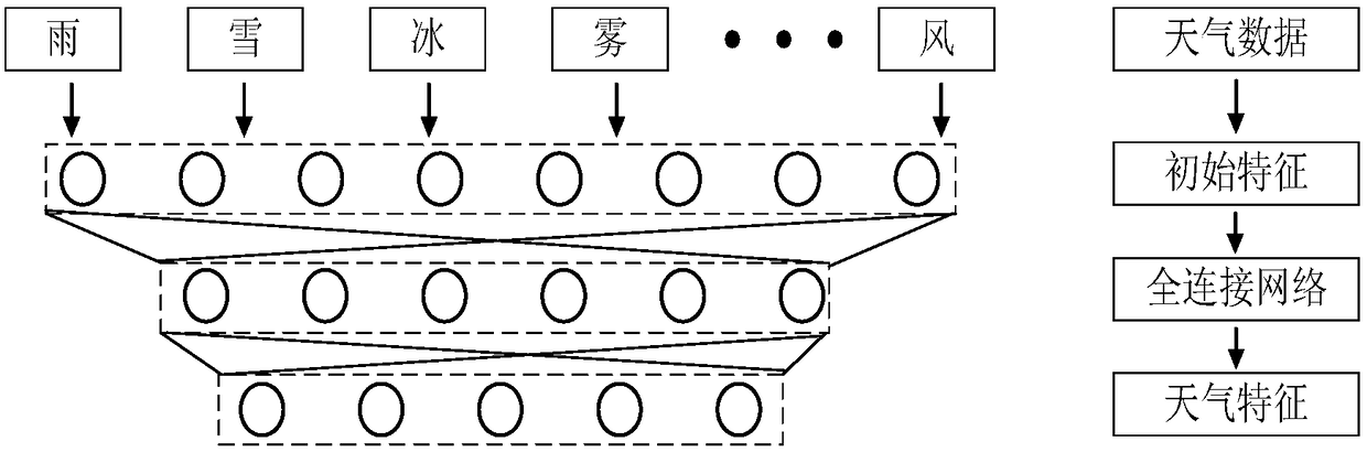
[0038] The present invention proposes an adaptive remote sensing scene classification method based on the combination of weather data and RGB data (color image), so as to make scene expression more refined and sufficient, thereby improving the accuracy of scene classification. The environmental information involved in the present invention includes common weather conditions, thereby forming weather phenomenon parameters, which correspond to initial weather characteristics.

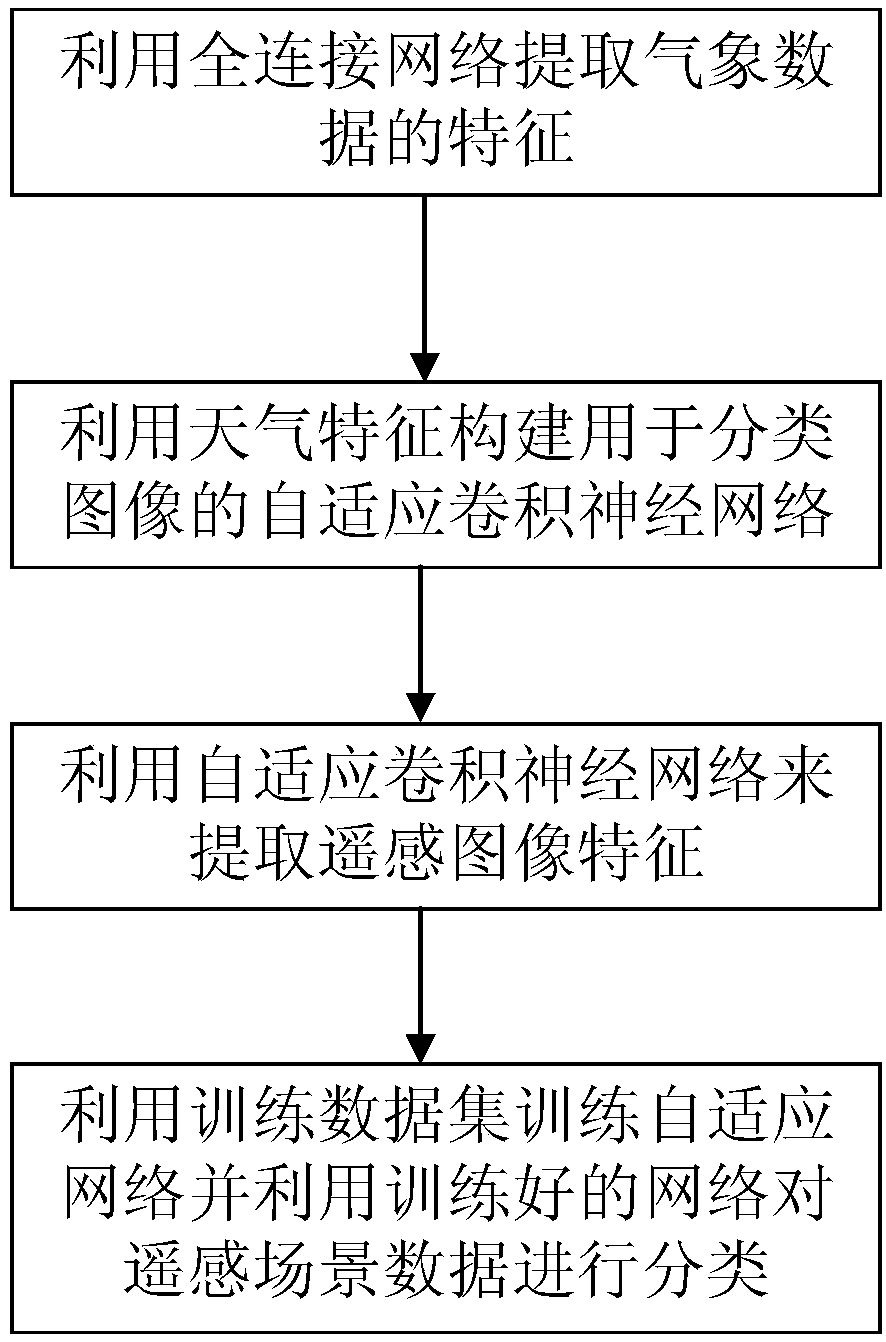
[0039] Such as figure 1 As shown, the adaptive remote sensing scene classification method for fusion of meteorological environment parameters and image information provided by the present invention mainly includes the following steps:

[0040] 1) After standardizing the weather data, use the fully connected network to obtain the weather data feature F wea ;

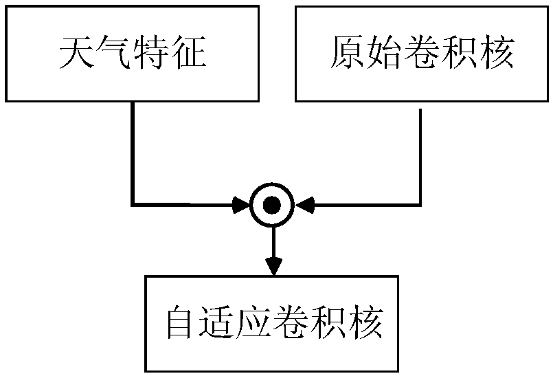
[0041] 2) Use the weather data feature F obtained in step 1) wea Construct an adaptive convolutional neural network;

[0042] 3) Use the adaptive convolutio...


PUM


Abstract

The invention relates to an adaptive remote sensing scene classification method based on fusion of meteorological environment parameters and image information, being able to be applied to the aspectsof geographical national condition prospecting and environment monitoring, for solving the problem that an existing method based on an image brightness value is easy to be interfered by the environment, so as to cause large feature difference based on visible light, and being not able to effectively recognize and understand the remote sensing scene. The adaptive remote sensing scene classificationmethod based on fusion of meteorological environment parameters and image information includes the steps: 1) after standardizing weather data, obtaining weather data feature Fwea by using a fully connected network; 2) using the weather data feature Fwea obtained in the step 1) to construct an adaptive convolutional neural network; 3) extracting the remote sensing image feature Frgb by using the adaptive convolutional neural network constructed in the step 2) and classifying the remote sensing image feature Frgb by means of a SoftMax classifier; and 4) training and testing the adaptive convolutional neural network, and using the trained adaptive convolutional neural network to classify the remote sensing image.

Description

Technical field [0001] The present invention relates to the technical field of information processing, in particular to an adaptive remote sensing scene classification method for fusion of meteorological environmental parameters and image information, and can be used for geography and national conditions survey and environmental monitoring. Background technique [0002] With the development of aerospace technology, more and more high-resolution satellites are launched into space to obtain data on the surface of the earth for disaster monitoring, agricultural production estimation and other purposes. Usually the data transmitted from satellites to the ground has a huge frame, in order to make full use of these For large-scale high-scoring remote sensing data, scene classification is a very important preprocessing method. It is of great help to subsequent tasks such as target recognition, change detection, and image retrieval. At present, remote sensing image scene classification me...

Claims


Application Information

Patent Timeline
Patent Type & Authority Applications(China)
IPC IPC(8): G06K9/00G06K9/46G06K9/62G06N3/04
CPCG06V20/13G06V10/462G06N3/045G06F18/241G06F18/214
Inventor 冯亚闯祁雷阮驰王允韬
Owner XI'AN INST OF OPTICS & FINE MECHANICS - CHINESE ACAD OF SCI
Why Eureka
Try Eureka