Cloud base height quick measurement method

A technology of cloud base height and measurement method, applied in the field of cloud height measurement, can solve the problems of high altitude error and low precision

Inactive Publication Date: 2019-04-16
山东省国土测绘院
View PDF5 Cites 1 Cited by
  • Summary
  • Abstract
  • Description
  • Claims
  • Application Information

AI Technical Summary

Problems solved by technology

The current main method is visual measurement, which is highly subjective and has low precision. The low altitude is abo...

Method used


Image

  • Cloud base height quick measurement method
  • Cloud base height quick measurement method
  • Cloud base height quick measurement method

Examples


Embodiment Construction

[0049] The following will clearly and completely describe the technical solutions in the embodiments of the present invention with reference to the accompanying drawings in the embodiments of the present invention. Obviously, the described embodiments are only some, not all, embodiments of the present invention. Based on the embodiments of the present invention, all other embodiments obtained by persons of ordinary skill in the art without making creative efforts belong to the protection scope of the present invention.

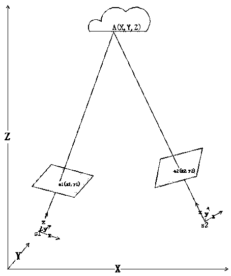
[0050] see figure 1 , in an embodiment of the present invention, a method for quickly measuring cloud base height, characterized in that: a cloud base height measuring device based on dual-sensor imaging, wherein s1 and s2 are the photography centers of the two sensors, and a1 and a2 are two images The image point of the same name of the film, point A is the cloud base point to be measured, after the sensor and the rotating platform are installed and integrate...


PUM


Abstract

The invention discloses a cloud base height quick measurement method. A double-sensor imaging cloud base high measuring device is adopted; s1 and s2 are the photographic centers of two sensors; a1 anda2 are the corresponding image points of two photos; an A point is a cloud base point to be measured; after a sensor and a rotating platform are installed and integrated, the main optical axis of thesensor and a rotating axis have a certain placement angle error, so the a placement angle constant is measured at first, and then cloud base height measurement is performed. The cloud base height quick measurement method includes the following steps that: step 1, a known target is observed, an orientation angle is measured, a cloud area is photographed, a cloud image is processed, and corresponding image points are extracted, and distortion correction is performed; and step 2, cloud base height calculation is performed: on the basis of elements of exterior orientation and the corresponding image points which are obtained previously, calculation is performed through the forward intersection principle of photogrammetry, so that cloud base height can be obtained.

Description

technical field [0001] The invention relates to the technical field of cloud height measurement, in particular to a method for quickly measuring cloud base height. Background technique [0002] Aerial photography is a complex systematic project, which requires the cooperation of multiple departments to carry out operations according to weather conditions. The main factors affecting aerial photography operations are aviation control conditions and weather conditions when aerial photography equipment and personnel are fixed. [0003] Weather factors that affect aerial photography mainly include cloud height and visibility, among which visibility factors include horizontal visibility and vertical visibility. These information have a certain impact on the quality of aerial remote sensing images. Basically consistent with the actual situation. Cloud height information is mainly reflected in image occlusion, because aerial remote sensing images are photographed on the ground in t...

Claims


Application Information

Patent Timeline
IPC IPC(8): G01C5/00G01C11/00
CPCG01C5/00G01C11/00
Inventor 刘建明张奇伟孔昭龙田茂荣赵云昌祝明然
Owner 山东省国土测绘院
Why Eureka
Try Eureka