Geographic space multi-dimensional data visual analysis method based on parallel coordinate axis arrangement

A technology of geographic space and parallel coordinates, applied in geographic information databases, database models, and visual data mining, etc., can solve the problems of difficult integration of geographic spatial objects, identification and presentation of multi-dimensional attribute information association features, and avoid overlapping , Strong practicability, enhance the effect of visual perception

Active Publication Date: 2019-05-14
ZHEJIANG UNIV OF FINANCE & ECONOMICS
View PDF4 Cites 5 Cited by
  • Summary
  • Abstract
  • Description
  • Claims
  • Application Information

AI Technical Summary

Problems solved by technology

[0006] The purpose of the present invention is to provide a visual analysis method for geospatial multidimensional data based on parallel coordinate axis arrangement, which can overcome the problems in the prior art that it is difficult to integrate geospatial objects in the parallel coordinate system, and it is difficult to identify and present the associated features of multidimensional attribute information

Method used


Image

  • Geographic space multi-dimensional data visual analysis method based on parallel coordinate axis arrangement
  • Geographic space multi-dimensional data visual analysis method based on parallel coordinate axis arrangement
  • Geographic space multi-dimensional data visual analysis method based on parallel coordinate axis arrangement

Examples


Embodiment Construction

[0017] Below in conjunction with the accompanying drawings, the method for visual analysis of geographic space multi-dimensional data based on the arrangement of parallel coordinate axes of the present invention will be described in detail, and the specific steps are as follows:

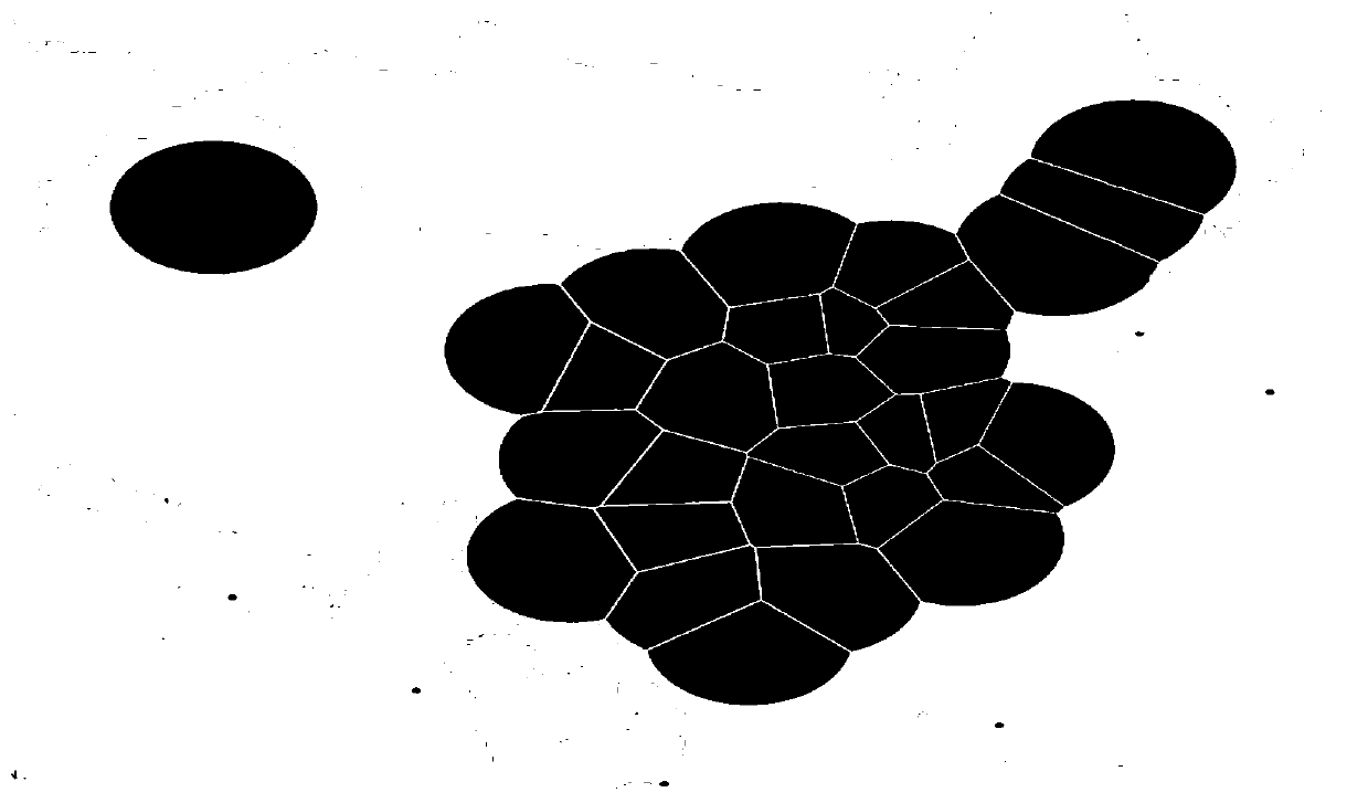
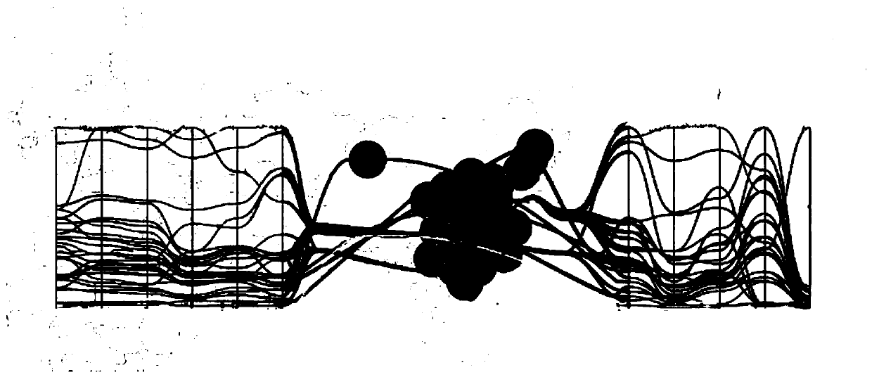
[0018] Step 1) read in initial geospatial multidimensional data F={f 1 ,f 2 ,..., f n}(n≥2), where f i is the i-th sample in the geospatial multidimensional data F, and n is the number of geospatial multidimensional data; perform cluster analysis on geospatial objects, display the cluster analysis results of geospatial objects with the help of a map, and obtain geospatial clustering view (such as figure 1 Shown) shows the distribution of cluster analysis results of geospatial objects on the map; uses parallel coordinates to display multi-dimensional attribute information, and uses kernel density clustering to perform cluster analysis on multi-dimensional attribute information to obtain attribute c...


PUM


Abstract

The invention discloses a geographic space multi-dimensional data visual analysis method based on parallel coordinate axis arrangement. The method comprises: carrying out the clustering analysis of geographic space objects, carrying out the visual display of the clustering analysis result of the geographic space objects on a map, and obtaining a view of geographic space clustering; displaying themulti-dimensional attribute information by using parallel coordinates, and performing clustering analysis on the multi-dimensional attribute information by using kernel density clustering to obtain anattribute category; the correlation between the clustering analysis result of the geographic space object and the attribute category is measured by using mutual information; embedding a parallel coordinate system into a view of geographic space clustering, determining the arrangement sequence of parallel coordinate axes in the parallel coordinate system by utilizing the correlation, and rearranging the parallel coordinate axes in the parallel coordinate system according to the arrangement sequence. The problems that geographic space objects are difficult to integrate in a parallel coordinatesystem and multi-dimensional attribute information association features are difficult to identify and present can be effectively solved.

Description

technical field [0001] The invention relates to a visual analysis method for geographic space multidimensional data based on parallel coordinate axis arrangement, and belongs to the technical field of geographic space multidimensional data visualization and image processing. Background technique [0002] Geographic information system and classic statistical analysis software are commonly used geospatial multidimensional attribute data analysis tools. GIS provides users with a wealth of functions such as data storage, processing, calculation, display, and spatial analysis. However, its relatively fixed analysis function is difficult to satisfy users' exploration and analysis of data personalization. However, statistical analysis software is difficult to effectively analyze large-scale and complex geospatial data, and there are certain limitations in the process of in-depth exploration and analysis of geospatial multi-dimensional attribute data. [0003] Compared with GIS and...

Claims


Application Information

Patent Timeline
Patent Type & Authority Applications(China)
IPC IPC(8): G06F16/29G06F16/26G06F16/28
Inventor 周志光
Owner ZHEJIANG UNIV OF FINANCE & ECONOMICS
Why Eureka
Try Eureka