
Improved imaging satellite sensor observation capability measurement method

A technology of imaging satellites and measurement methods, applied in the direction of measuring devices, radio wave measurement systems, satellite radio beacon positioning systems, etc., can solve the problem of ignoring the comprehensive influence of sensors and its degree of influence, it is difficult to adapt to flood disaster observation tasks, and lack of radar Sensor evaluation and other issues

Active Publication Date: 2019-07-05
武汉中地大智慧城市研究院有限公司
View PDF6 Cites 0 Cited by
  • Summary
  • Abstract
  • Description
  • Claims
  • Application Information

AI Technical Summary

Problems solved by technology

Patent CN103093098B proposes a quantitative evaluation method for the dynamic observation ability of satellite optical sensors. This method evaluates the observation ability of optical sensors from the perspective of task adaptability, but this method ignores the static and dynamic capabilities of the sensor. In addition, this method is mainly oriented to optical sensors and lacks the evaluation of radar sensors, so it is difficult to adapt to flood disaster observation tasks

Method used


Image

  • Improved imaging satellite sensor observation capability measurement method
  • Improved imaging satellite sensor observation capability measurement method
  • Improved imaging satellite sensor observation capability measurement method

Examples


Embodiment 1

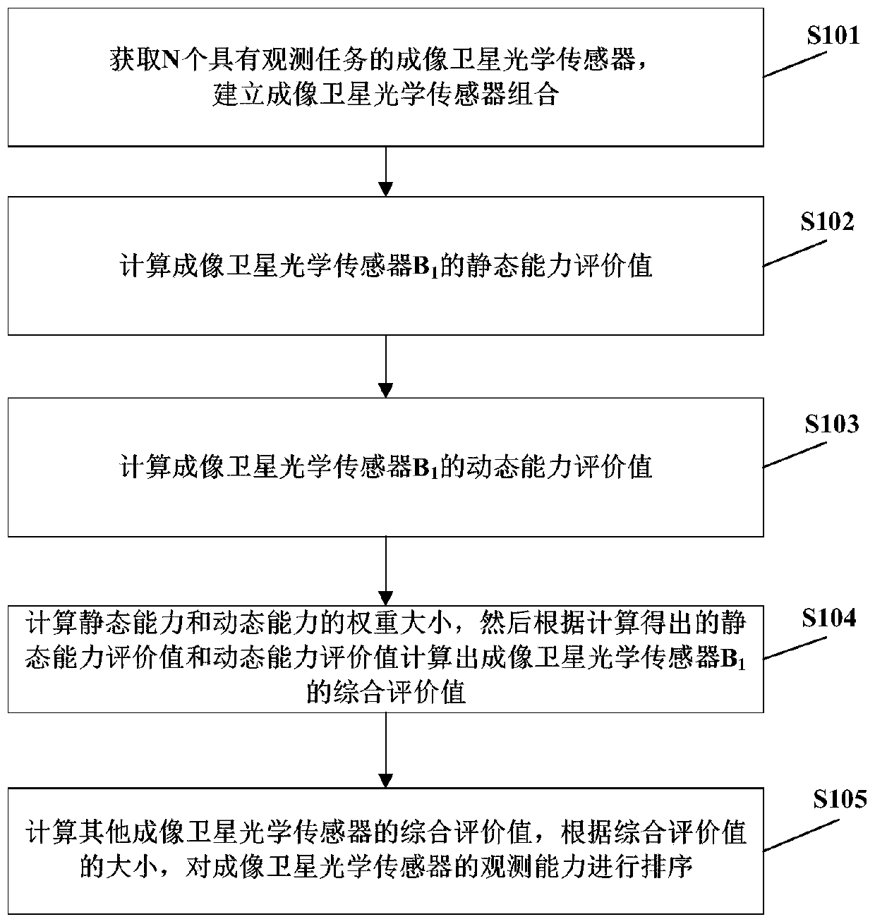
[0065] Please refer to figure 1 , Embodiment 1 of the present invention provides an improved measuring method for imaging satellite sensor observation capability, comprising the following steps:

[0066] Step S101, obtain N imaging satellite optical sensors with observation tasks, denoted as B 1 , B 2 ,...B N , to establish an imaging satellite optical sensor combination {B 1 , B 2 ,...B N , N∈R}, R represents a natural number;

[0067] Step S102, acquiring an imaging satellite optical sensor B in the imaging satellite optical sensor combination 1 The spatial resolution, radiation resolution and spectral resolution, and then according to the spatial resolution, radiation resolution and spectral resolution to calculate the spatial resolution excellence, radiation resolution excellence, spectral resolution excellence, and then according to the spatial resolution The imaging satellite optical sensor B is calculated by linear weighting 1 static capacity evaluation value; ...

Embodiment 2

[0119]The difference between Embodiment 2 of the present invention and Embodiment 1 is that the sensor with the observation task is an imaging satellite microwave sensor, and the static capability evaluation value of the imaging satellite microwave sensor is based on the spatial resolution of the imaging satellite microwave sensor, and the radiation resolution is excellent. The calculation process of the static capability evaluation value of imaging satellite microwave sensors refers to Figure 5 , the calculation process of the spatial resolution coincidence degree of the imaging satellite microwave sensor and the excellent degree of radiation resolution are the same as the calculation process of the spatial resolution coincidence degree and the radiation resolution excellence degree of the imaging satellite optical sensor in Example 1, and the calculation process of the imaging satellite microwave sensor The calculation process of the degree of excellence of the polarization ...


PUM


Abstract

The invention provides an improved imaging satellite sensor observation capability measurement method. The method comprises the steps that a number of imaging satellite sensors with observation tasksare acquired to establish an imaging satellite sensor combination; the attribute parameters of an imaging satellite sensor in the imaging satellite sensor combination are acquired to calculate the static capability evaluation value of the imaging satellite sensor; according to the attribute parameters of the observation task, the time when the imaging satellite sensor reaches the visible area of the observation task, the effective coverage area in the observation task area, and the estimated cloud coverage of an image area at the time of image acquiring, the dynamic capability evaluation valueis calculated; the weight of the static capability and the dynamic capability is determined, and the static capability evaluation value and the dynamic capability evaluation value are combined to acquire the comprehensive evaluation value by weighting; and the comprehensive evaluation values of other imaging satellite sensors in the imaging satellite sensor combination are calculated respectively; and the observation capability of the imaging satellite sensors is ranked based on the calculated comprehensive evaluation values.

Description

technical field [0001] The invention relates to the field of smart earth observation technology, in particular to an improved method for measuring the observation capability of imaging satellite sensors. Background technique [0002] Floods are one of the most frequent and severe disasters in the world. In the face of extremely destructive flood disasters, traditional flood mapping methods based on ground surveys and aerial monitoring are time-consuming, expensive, and difficult to apply in severe weather. In contrast, satellite sensors have a series of advantages such as short revisit period, wide coverage, strong timeliness, and will not be affected by the ground monitoring environment, making them play a huge role in flood disasters. . With the development of aerospace technology, the number of satellites in orbit in the sky is gradually increasing. In order to make reasonable use of satellite sensor resources to monitor disasters, it is very important to measure and ev...

Claims


Application Information

Patent Timeline
Patent Type & Authority Applications(China)
IPC IPC(8): G01S19/07H04N17/00
CPCG01S19/07H04N17/00
Inventor 晁怡许辉胡楚丽陈能成
Owner 武汉中地大智慧城市研究院有限公司
Learn More