Method for capturing illegal emergency lane occupation based on unmanned aerial vehicle aerial photography technology

A technology of emergency lanes and drones, which is applied to computer parts, traffic control systems of road vehicles, instruments, etc.

Inactive Publication Date: 2019-07-19
NANJING MAGICSKY AVIATION TECH
View PDF5 Cites 11 Cited by
  • Summary
  • Abstract
  • Description
  • Claims
  • Application Information

AI Technical Summary

Problems solved by technology

The invention realizes the automatic flight control of the UAV, can ignore any traffic obstacles, accurately locates the emergency lane area in real time through video image analysis technology, and automatically captures the vehicles appea

Method used


Image

  • Method for capturing illegal emergency lane occupation based on unmanned aerial vehicle aerial photography technology
  • Method for capturing illegal emergency lane occupation based on unmanned aerial vehicle aerial photography technology
  • Method for capturing illegal emergency lane occupation based on unmanned aerial vehicle aerial photography technology

Examples


Embodiment Construction

[0032] Below is further detailed description of the present invention according to accompanying drawing and example:

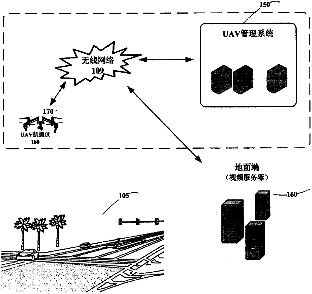
[0033] figure 1 It is a schematic diagram of the framework of the method for illegal capture and occupation of emergency lanes based on UAV aerial photography technology according to the present invention. Its framework includes the UAV management system 150 and the ground terminal.

[0034] The UAV management system 150, including UAV 170 and aerial camera 180, as well as wireless network 109 and road 105, receives the service request, and assigns UAV 170 to perform snapshot illegal occupation according to the configured strategy (for example, the closest distance strategy). Emergency lane missions.

[0035] The ground station includes a video server 160 .

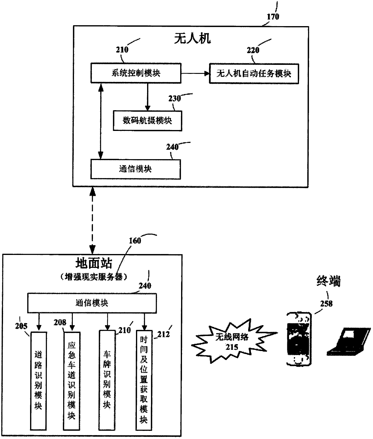
[0036] figure 2 It is a schematic diagram of the functional modules of the method for illegal capture and occupancy of the emergency lane based on UAV aerial photography technology described in the p...


PUM


Abstract

The invention discloses a method for capturing illegal emergency lane occupation based on unmanned aerial vehicle aerial photography technology. The method is characterized by comprising the followingsteps: acquiring a real-time video of a road aerially photographed by an unmanned aerial vehicle, identifying the road, identifying the emergency lane, and identifying a license plate of a vehicle inthe emergency lane, acquiring the capturing time and capturing location and like information of the captured vehicle, and generating a terminal user digital certificate; sending the captured road traffic illegal vehicle and the related information to a background server (to-be-audited). Through the method disclosed by the invention, the vehicle in the emergency lane can be efficiently and precisely captured in real time from all sights.

Description

technical field [0001] The invention relates to the technical field of unmanned aerial vehicle application and data collection of road violations, in particular to the construction of a fast, efficient and full-view road violation capture method. Background technique [0002] The English abbreviation included in the present invention is as follows: [0003] UAV: Unmanned Aerial Vehicles [0004] IMU: Inertial measurement unit inertial measurement unit [0005] GPS: Global Positioning System Global Positioning System [0006] UCS: UAV Control System drone control system [0007] GCS: Ground Control Station ground control station [0008] DEM: Digital Elevation Model digital elevation model [0009] DOM: Digital Orthophoto Map digital orthophoto map [0010] ADS: Airborne Digital Sensor airborne digital sensor [0011] ROI: Region Of Interest Interest area [0012] In recent years, as the number of vehicles continues to rise, road congestion often occurs, and vehicles ...

Claims


Application Information

Patent Timeline
IPC IPC(8): G08G1/017G06K9/00
CPCG08G1/0175G06V20/182G06V20/39G06V20/13
Inventor 陈尧魏琳
Owner NANJING MAGICSKY AVIATION TECH
Why Eureka
Try Eureka