Unlock instant, AI-driven research and patent intelligence for your innovation.

A Dem-based Automatic Fault Plane Recognition Method

A technology of automatic identification and fault plane, applied in the application field of geographic information technology, can solve the problems of long work cycle, difficult quality assurance, difficult to deal with fault plane system, etc., and achieve the effect of high execution efficiency and good extraction effect.

Active Publication Date: 2021-09-28
南京泛在地理信息产业研究院有限公司 +1
View PDF5 Cites 0 Cited by
  • Summary
  • Abstract
  • Description
  • Claims
  • Application Information

AI Technical Summary

Problems solved by technology

This manual interpretation method has a long working cycle, the analytical results are highly subjective, the quality is difficult to guarantee, and it is difficult to deal with complex fault plane systems

Method used


Image

  • A Dem-based Automatic Fault Plane Recognition Method
  • A Dem-based Automatic Fault Plane Recognition Method
  • A Dem-based Automatic Fault Plane Recognition Method

Examples


Embodiment Construction

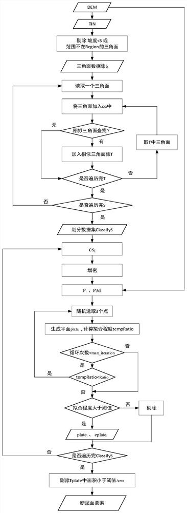
[0069] This embodiment provides a method for automatic identification of fault planes based on DEM, such as figure 1 As shown, it specifically includes the following steps:

[0070] Step 1: Convert the DEM data containing the area to be identified into TIN triangulation data, and filter according to the set boundary and slope threshold R1 to obtain a set S of triangles in the area to be identified with a slope greater than R1.

[0071] Wherein, what the experimental data of this embodiment adopts is the 5m resolution DEM data of Lushan area, such as figure 2 As shown, the projection is WGS84 Mercator projection, and the XY offsets are -12888513.279990086m, -3402357.4105560426m respectively.

[0072] Step 1 specifically includes:

[0073] (1-1) For the DEM data that includes the region to be identified, generate the Region to be identified according to the set boundary threshold edge_limit; in this embodiment, the edge_limit is 2000m, and the four vertices that generate the ...


PUM


Abstract

The invention discloses a method for automatically extracting fault planes based on DEM. The specific steps include: (1) converting DEM data into TIN triangular surfaces, and screening the slope and range of the triangular surfaces; (2) consistent occurrences based on the triangular surfaces (3) Carry out spatial densification processing on the divided triangular faces to obtain densified 3D coordinate points; (4) Based on the set of 3D coordinate points, generate pseudo (5) Eliminate invalid fault planes to generate fault plane elements. Compared with the prior art, the invention has higher degree of automation and better extraction effect, which is basically consistent with field investigation results.

Description

technical field [0001] The invention relates to the application field of geographic information technology, in particular to a method for automatic recognition of fault planes based on DEM. Background technique [0002] Fault planes are triangular cliffs formed by fault cliffs cut and eroded by rivers or gullies. Faults have an important impact on the development of regional geological structures, and also play a decisive role in the distribution of oil, natural gas and groundwater, so the identification of fault planes is a very important link in geological surveys. [0003] At present, most fault interpretation work is done manually by analysts based on field surveys or remote sensing images. This manual interpretation method has a long working cycle, the analytical results are highly subjective, the quality is difficult to guarantee, and it is difficult to deal with complex fault plane systems. Therefore, it is of great research significance and practical value to reali...

Claims


Application Information

Patent Timeline
Patent Type & Authority Patents(China)
IPC IPC(8): G06F16/29
CPCG06F16/29
Inventor 钟秀明李安波闾国年
Owner 南京泛在地理信息产业研究院有限公司