
Remote sensing image building area land utilization attribute space migration method

A technology of remote sensing images and building areas, applied to instruments, character and pattern recognition, computer components, etc., can solve problems such as low efficiency, error-prone, and cost a lot of manpower and material resources, and achieve the effect of improving the efficiency of assignment

Active Publication Date: 2019-11-19
SUZHOU ZHONGKE IMAGE SKY REMOTE SENSING TECH CO LTD +1
View PDF3 Cites 0 Cited by
  • Summary
  • Abstract
  • Description
  • Claims
  • Application Information

AI Technical Summary

Problems solved by technology

[0003] However, in the prior art, when using remote sensing images to interpret land use, the land use attributes in the remote sensing images are manually interpreted, and the land use attributes are further assigned. However, the manual assignment of land use attributes has the following problems : (1) Manual assignment of land use attributes requires a lot of manpower and material resources, and the efficiency is low; (2) Manual assignment of land use attributes is prone to errors

Method used


Image

  • Remote sensing image building area land utilization attribute space migration method
  • Remote sensing image building area land utilization attribute space migration method
  • Remote sensing image building area land utilization attribute space migration method

Examples


Embodiment Construction

[0033] The technical solutions of the embodiments of the present invention will be clearly and completely described below in conjunction with the accompanying drawings of the present invention.

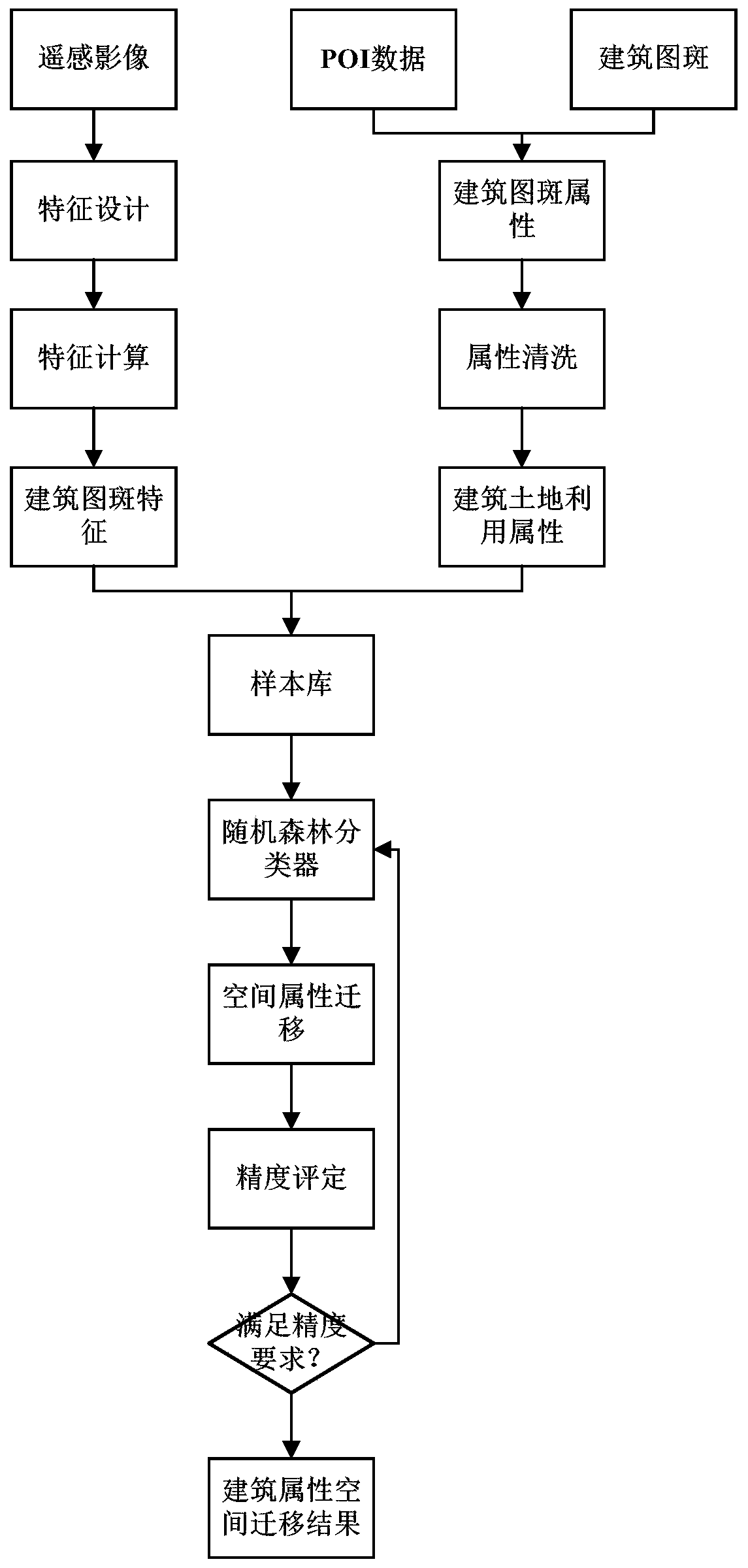
[0034] A method for spatial migration of land use attributes in remote sensing image building areas disclosed by the present invention uses POI (Point Of Interest) data to obtain the architectural attributes and characteristics of architectural spots with POI points in the building area, and further uses The building map of building attributes and characteristics trains a random forest classifier (RF, RandomForest), so that the random forest classifier can predict the building attributes of building spots without POI points, and finally realize the spatial migration of land use attributes, improving remote sensing Assignment efficiency of image land use attributes.

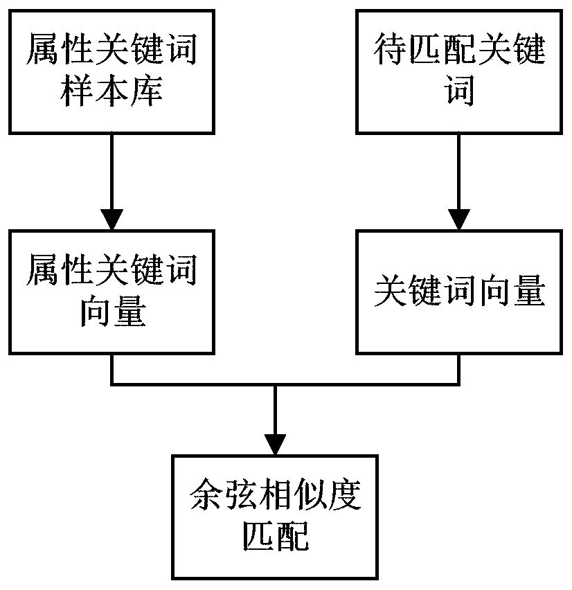
[0035] like figure 1 As shown, it is a method for spatial migration of land use attributes of remote sensing image bui...


PUM


Abstract

The invention discloses a remote sensing image land utilization attribute space migration method, which comprises the steps of obtaining POI data of a remote sensing image building area, carrying outbuilding attribute cleaning on the POI data, and further establishing a mapping relationship between obtained building attributes and land utilization attributes; performing drop point analysis on thebuilding pattern spots of the remote sensing image building area and the POI data after attribute cleaning, and obtaining building land utilization attributes and features of the building pattern spots with POI drop points; and inputting the building pattern spots with the building land utilization attributes and characteristics into a random forest classifier for training, and predicting the building pattern spots without the POI drop points through the random forest classifier, so that the building pattern spots without the POI drop points obtain the building land utilization attributes. According to the method, spatial migration of the land utilization attributes is realized, and the assignment efficiency of the remote sensing image land utilization attributes is improved.

Description

technical field [0001] The invention relates to the technical field of image processing of remote sensing images, in particular to a method for spatial migration of land use attributes of building areas of remote sensing images. Background technique [0002] With the rapid growth of population, the available land resources are getting less and less, and people have gradually paid attention to the issue of land use. In the field of remote sensing technology, land use has always been an important task in the interpretation of remote sensing images, and it is also an important reference for the rational allocation of resources and municipal planning. Compared with the traditional land survey once every ten years to detect the national land use situation, interpreting the land use situation through remote sensing images can provide a reliable and efficient solution for the national land survey work. [0003] However, in the prior art, when using remote sensing images to interpr...

Claims


Application Information

Patent Timeline
Patent Type & Authority Applications(China)
IPC IPC(8): G06K9/00G06K9/32G06K9/62
CPCG06V20/176G06V10/25G06F18/24323
Inventor 李俊刚周楠魏春山胡晓东骆剑承王嘉炜刘畅韩小妹李昕张竹林
Owner SUZHOU ZHONGKE IMAGE SKY REMOTE SENSING TECH CO LTD
Learn More