Fast real-time processing method and system for airborne insar data

A real-time processing, POS data technology, applied in image data processing, image enhancement, image analysis and other directions, can solve the problems of high cost, affecting the overall consistency and continuity of DEM, abnormal elevation, etc., to improve efficiency and flexible extraction. , the effect of improving the accuracy

Active Publication Date: 2022-04-12
三亚中科遥感研究所 +1
View PDF5 Cites 0 Cited by
  • Summary
  • Abstract
  • Description
  • Claims
  • Application Information

AI Technical Summary

Problems solved by technology

In the prior art, the DEM and DOM are usually obtained by aerial photogrammetry, which has the advantages of high efficiency, high precision and low labor intensity, and is mainly carried out by a full digital photogrammetry workstation, but the aerial photogrammetry method When acquiring data, it is necessary to consider the influence of light and weather factors, which are restricted by conditions such as clouds, fog, rain, dust, and light, and are subject to aviation control, so the cost is relatively high; when using aerial photogrammetry to obtain DEM, the same There will be elevation anomalies between different images in the flight belt or adjacent images between different flight belts, which will affect the overall consistency and continuity of the acquired DEM

Method used


Image

  • Fast real-time processing method and system for airborne insar data
  • Fast real-time processing method and system for airborne insar data
  • Fast real-time processing method and system for airborne insar data

Examples


Embodiment Construction

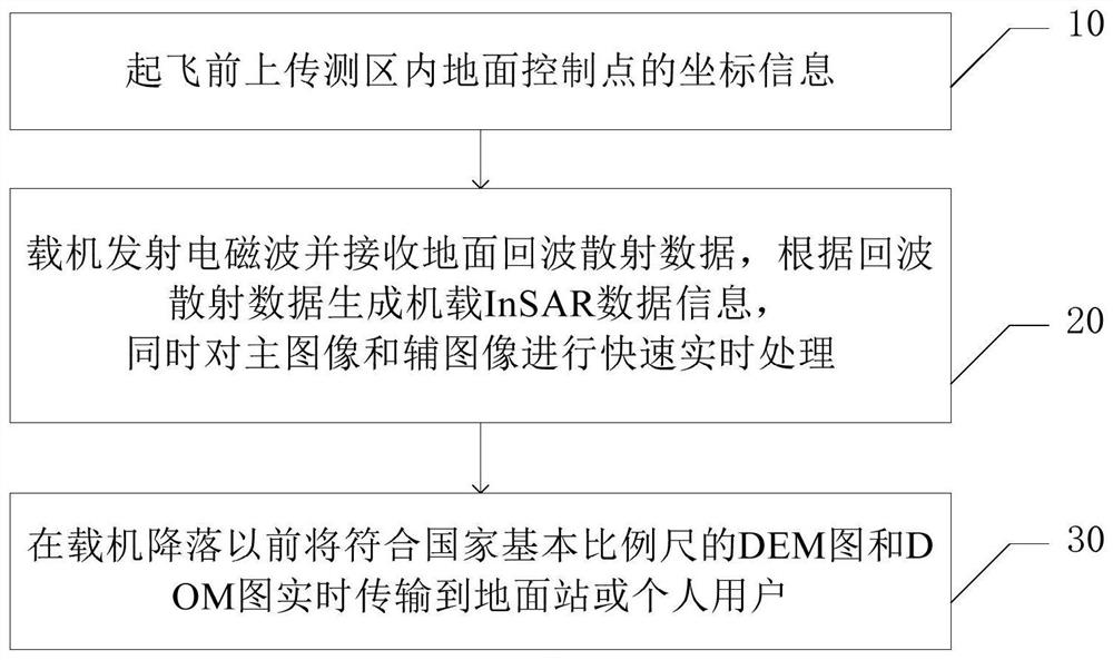
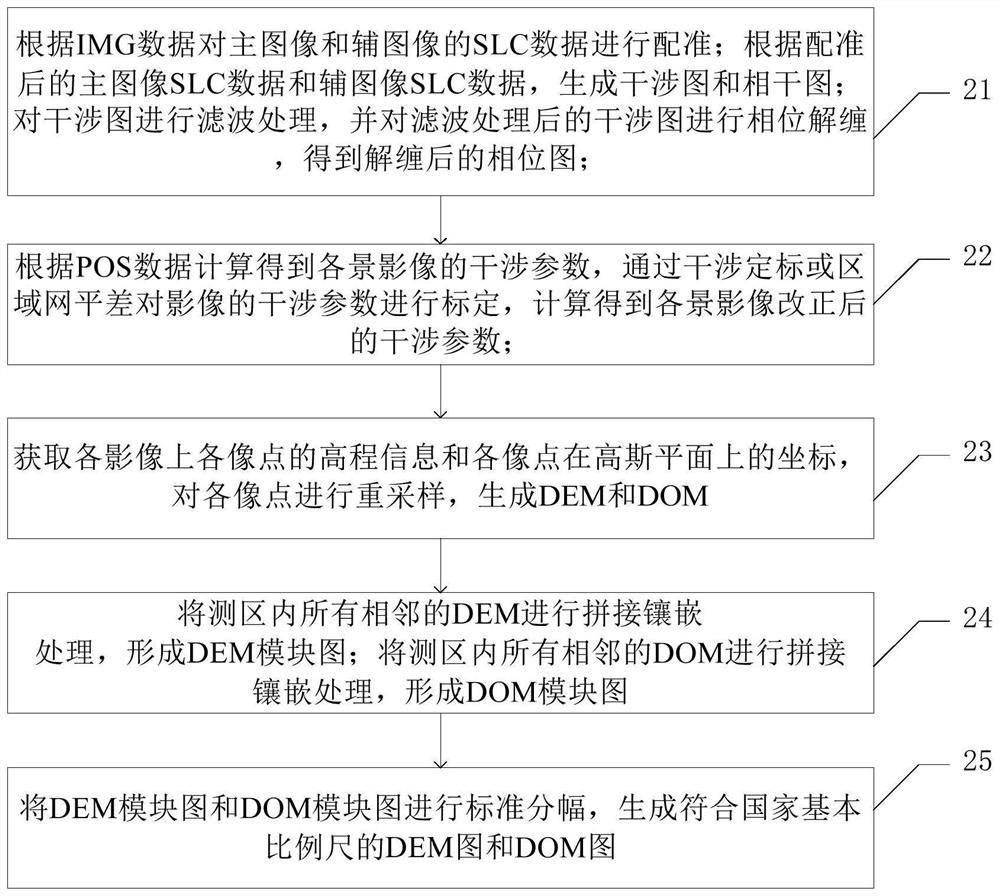
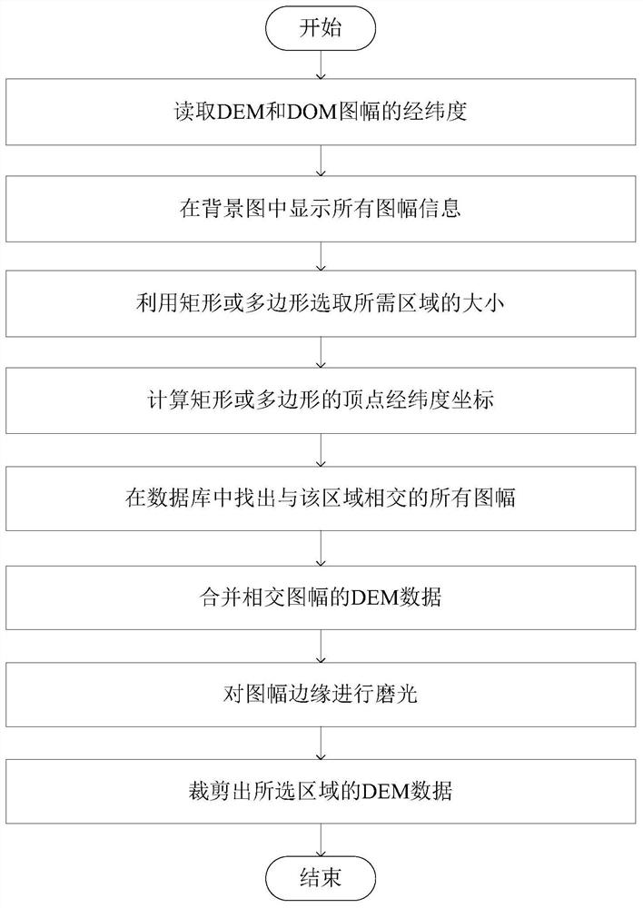
[0062] Various exemplary embodiments of the present invention will now be described in detail with reference to the accompanying drawings. It should be noted that the relative arrangements of components and steps, numerical expressions and numerical values ​​set forth in these embodiments do not limit the scope of the present invention unless specifically stated otherwise.

[0063] The following description of at least one exemplary embodiment is merely illustrative in nature and in no way taken as limiting the invention, its application or uses.

[0064] Techniques, methods and devices known to those of ordinary skill in the relevant art may not be discussed in detail, but where appropriate, such techniques, methods and devices should be considered part of the description.

[0065] In all examples shown and discussed herein, any specific values ​​should be construed as exemplary only, and not as limitations. Therefore, other instances of the exemplary embodiment may have dif...


PUM


Abstract

The invention discloses a fast and real-time processing method and system for airborne InSAR data, and relates to the technical field of InSAR data processing, including: uploading coordinate information of ground control points in the survey area before take-off; Data, generate airborne InSAR data information based on the echo scattering data and perform fast real-time processing, and then transmit the DEM map and DOM map that conform to the national basic scale to the ground station or individual users in real time before the aircraft lands. This application uploads ground control point information before take-off, and after transmitting electromagnetic waves and receiving ground echo scattering data through the carrier aircraft, fast, real-time, and automatic data processing can be performed on the carrier aircraft, and the data can be processed before or after the aircraft lands. The DEM and DOM that conform to the national standard scale are transmitted to the ground workstation or individual users, which is conducive to improving the efficiency of data processing and transmission, and better meeting user needs.

Description

technical field [0001] The present invention relates to the technical field of InSAR data processing, and more specifically, to a fast real-time processing method and system for airborne InSAR data. Background technique [0002] A digital elevation model (Digital Elevation Model, DEM) is a physical ground model that describes the spatial distribution of regional geomorphology, is a virtual representation of geomorphology, and uses a set of ordered numerical arrays to represent ground elevation. Digital Orthophoto Map (DOM) is a digital orthophoto dataset generated by using DEM to perform orthorectification, edge joining, color adjustment, mosaicking, and cutting according to a certain range of aerospace images. [0003] InSAR (Interferometric Synthetic Aperture Radar; abbreviation: interferometric radar measurement) technology originated in the United States, and has been continuously improved and matured in developed countries in Europe and the United States, and its applic...

Claims


Application Information

Patent Timeline
Patent Type & Authority Patents(China)
IPC IPC(8): G06T5/00G06T5/40G06T5/50G06T3/40G06T7/33
CPCG06T5/002G06T5/006G06T5/40G06T5/50G06T3/4038G06T7/33G06T2207/10044
Inventor 孙中昶李永杰韦立登郭华东
Owner 三亚中科遥感研究所
Why Eureka
Try Eureka