A display method and device of extended tile map based on webgis environment

A technology of tiled maps and tiles, which is applied to expand the display field of tiled maps based on the WebGIS environment, can solve problems such as map display blanks, and achieve the effect of improving poor experience

Active Publication Date: 2022-02-01
吉奥时空信息技术股份有限公司
View PDF5 Cites 0 Cited by
  • Summary
  • Abstract
  • Description
  • Claims
  • Application Information

AI Technical Summary

Problems solved by technology

[0006] In view of the above problems, the object of the present invention is to provide a display method based on the extended tile map in the WebGIS environment, aiming to solve the technical problem that the map display is blank when the zoom level exceeds the maximum level in the tile cache data set

Method used


Image

  • A display method and device of extended tile map based on webgis environment
  • A display method and device of extended tile map based on webgis environment

Examples


Embodiment 1

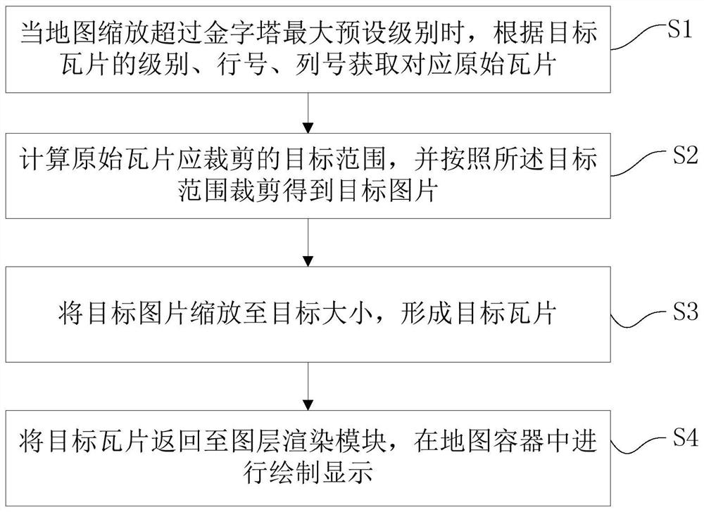
[0031] figure 1 The flowchart of the method for displaying the extended tile map based on the WebGIS environment provided by the embodiment of the present invention is shown, and only the parts related to the embodiment of the present invention are shown for convenience of description.

[0032] like figure 1 As shown, the display method of the extended tile map based on the WebGIS environment provided by this embodiment includes the following steps:

[0033] Step S1. When the map zoom exceeds the maximum preset level of the pyramid, obtain the corresponding original tile according to the level, row number, and column number of the target tile.

[0034] When the user zooms the map to a display interface, under normal circumstances, the map will have a scale data. The system finds the matching level number according to the map scale, and calculates the start and end line numbers of the requested tiles according to the map window range, The start and end column numbers can dire...

Embodiment 2

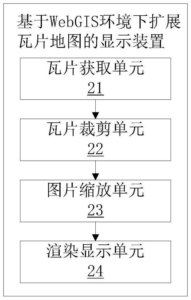
[0048] figure 2 The structure of the display device based on the extended tile map in the WebGIS environment provided by the embodiment of the present invention is shown, and only the parts related to the embodiment of the present invention are shown for convenience of description.

[0049] like figure 2 As shown, the display device based on the extended tile map under the WebGIS environment provided by this embodiment includes:

[0050] The tile acquisition unit 21 is used to obtain the corresponding original tile according to the level, row number, and column number of the target tile when the map zoom exceeds the maximum preset level of the pyramid;

[0051] The tile cropping unit 22 is used to calculate the target range that the original tile should be cropped, and crop the target picture according to the target range;

[0052] The picture zooming unit 23 is used for scaling the target picture to a target size to form a target tile;

[0053] The rendering and displayi...


PUM


Abstract

The present invention is applicable to the field of geographic information systems, and provides a method and device for displaying an extended tile map in a WebGIS environment. The method includes: obtaining original tiles, calculating the clipping target range, clipping pictures, zooming to the target size, and target tiles. Steps such as slice rendering, drawing and displaying. The present invention uses the existing cached tile cache data set as a data source, and when the zoom level exceeds the maximum preset level of the pyramid, the target tile data exceeding the pyramid level in the tile map service is reconstructed through calculation, and then rendered and displayed , there is no need for service publishers to continue to plan larger-scale slice data, the entire implementation process is simple, low-cost, and effective.

Description

technical field [0001] The invention belongs to the field of geographic information systems, and in particular relates to a method and device for displaying extended tile maps based on a WebGIS environment. Background technique [0002] In the WebGIS platform, massive raster and vector data are published as tile map services, which are provided to clients for calling and displaying. [0003] The main principle of the tile map service is to construct the original data into pictures of each level according to a certain pyramid scheme in advance, forming a tile cache data set. The main parameters of the pyramid include the origin of the image cut (x, y), the pixel width and height of a single image, and information at each level (level number, row number, column number, and geographic resolution). Each layer and its geographic resolution are defined in four Defined in the form of a fork tree, the geographic resolution is given by It is calculated that the row number and colu...

Claims


Application Information

Patent Timeline
Patent Type & Authority Patents(China)
IPC IPC(8): G06F16/957G06F16/54G06F16/29
CPCG06F16/9577G06F16/9574G06F16/54G06F16/29
Inventor 李论凌海锋黄宇林洋杜大雾唐超
Owner 吉奥时空信息技术股份有限公司
Why Eureka
Try Eureka