Rapid metal mineral exploration and evaluation method

An evaluation method and fast technology, applied in the field of geology and mineral resources, can solve the problems of remote sensing prospecting model research without typical deposits and ore-concentrated areas

Pending Publication Date: 2020-04-10
XIAN CENT OF GEOLOGICAL SURVEY CGS
View PDF3 Cites 8 Cited by
  • Summary
  • Abstract
  • Description
  • Claims
  • Application Information

AI Technical Summary

Problems solved by technology

[0005] The purpose of the present invention is to provide a rapid exploration and evaluation method for metal minerals, which is equipped with special multi-level remote sensing interpretation work for ore-forming / controlling geological factors, and special remote sensing prospecting model research for typical ore deposits and ore-concentrated areas. The advantages of the work solve the problem that there is no special multi-level remote sensing interpretation work for ore-forming / controlling geological factors, and there is no special remote sensing prospecting model research for typical deposits and ore-concentrated areas.
[0007] A: Remote sensing interpretation of regional structural framework: apply Landsat TM / ETM, Worldview-2 and Aster satellite remote sensing data, carry out digital image processing, and produce satellite remote sensing image maps of 1:500,000 to 1:250,000 to solve Focusing on major basic geological issues related to ore deposits, carry out remote sensing interpretation of linear and circular structures, establish a remote sensing regional structural framework, and lay a foundation for the study of regional metallogenic conditions and metallogenic laws;

Method used


Image

  • Rapid metal mineral exploration and evaluation method

Examples


Embodiment 1

[0031] A method for rapid exploration and evaluation of metal minerals, comprising the following steps:

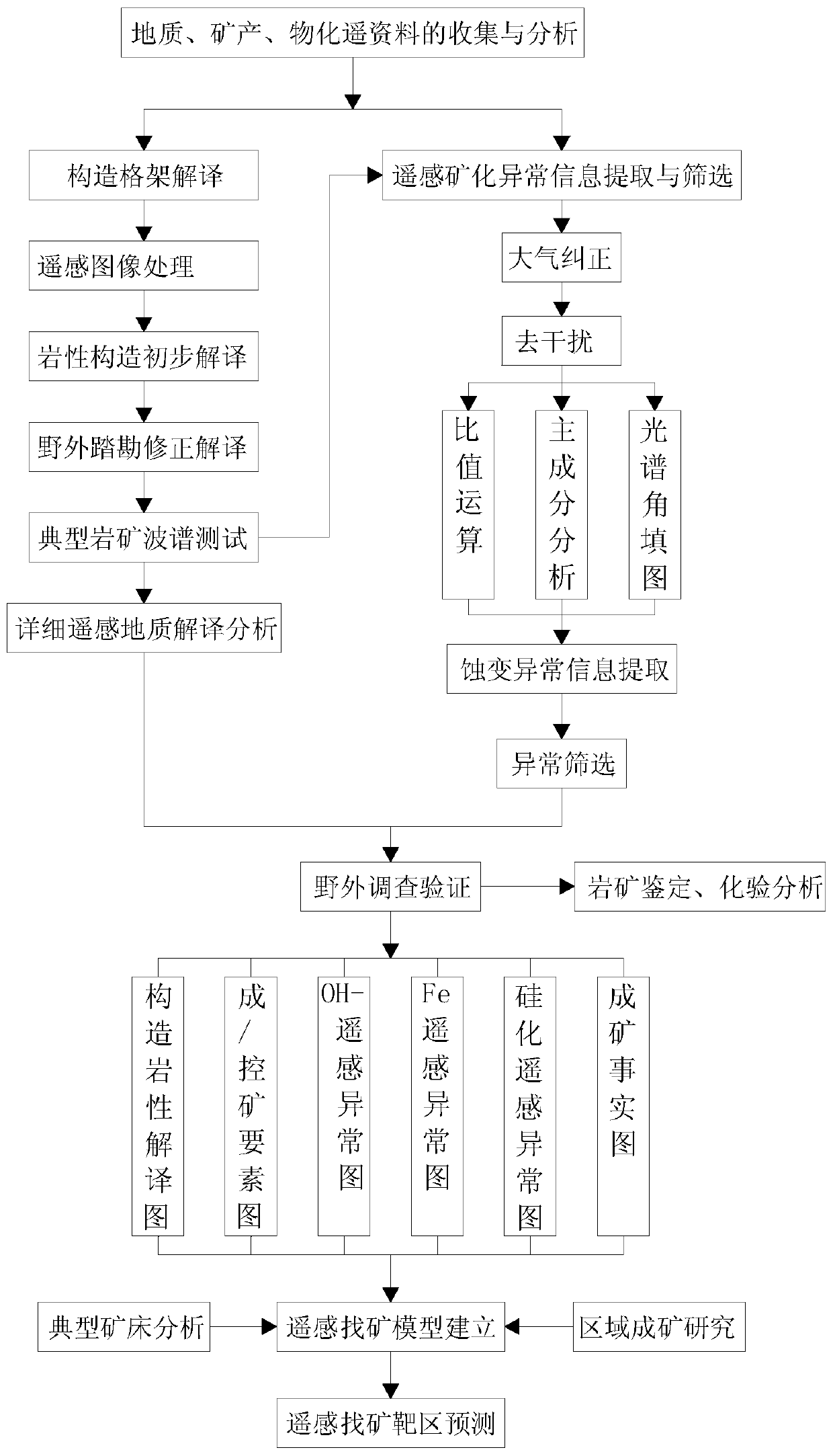
[0032]A: Remote sensing interpretation of regional structural framework: apply Landsat TM / ETM, Worldview-2 and Aster satellite remote sensing data, carry out digital image processing, and produce satellite remote sensing image maps of 1:500,000 to 1:250,000 to solve Focusing on major basic geological issues related to ore deposits, carry out remote sensing interpretation of linear and circular structures, establish a remote sensing regional structural framework, and lay a foundation for the study of regional metallogenic conditions and metallogenic laws;

[0033] B: Research and construction of remote sensing prospecting model: On the basis of known typical ore deposits (points), analysis of remote sensing features of ore concentration areas, and extraction of mineralized alteration remote sensing abnormal information, guided by the latest theory of ore deposits, fully appl...

Embodiment 2

[0044] A method for rapid exploration and evaluation of metal minerals, comprising the following steps:

[0045] A: Remote sensing interpretation of regional structural framework: apply Landsat TM / ETM, Worldview-2 and Aster satellite remote sensing data, carry out digital image processing, and produce satellite remote sensing image maps of 1:500,000 to 1:250,000 to solve Focusing on major basic geological issues related to ore deposits, carry out remote sensing interpretation of linear and circular structures, establish a remote sensing regional structural framework, and lay a foundation for the study of regional metallogenic conditions and metallogenic laws;

[0046] B: Research and construction of remote sensing prospecting model: On the basis of known typical ore deposits (points), analysis of remote sensing features of ore concentration areas, and extraction of mineralized alteration remote sensing abnormal information, guided by the latest theory of ore deposits, fully app...


PUM


Abstract

The invention discloses a rapid metal mineral exploration and evaluation method. The method comprises a step of (A) remote sensing interpretation of regional structure framework: satellite remote sensing data such as Landsat TM / ETM, Worldview-2 and Aster are applied, digital image processing is carried out, a 1: 500,000-1: 25,0000 satellite remote sensing image map is made, linear and annular structure remote sensing interpretation is carried out with the key point of solving major basic geological problems related to mineralization, a remote sensing area structure framework is established, and a foundation is laid for research of area mineralization conditions and mineralization rules. According to the method, special multi-level remote sensing interpretation work is carried out for ore-forming / ore-controlling geological factors; aiming at the advantages of special remote sensing prospecting model research and the like on typical ore deposits and ore gathering areas, the problems thatspecial multi-level remote sensing interpretation work is not carried out on ore formation / control geological factors, and special remote sensing prospecting model research and the like are not carried out on the typical ore deposits and ore gathering areas are solved.

Description

technical field [0001] The invention relates to the technical field of geology and mineral resources, in particular to a rapid exploration and evaluation method for metal mineral resources. Background technique [0002] The evaluation and detection of mineral resources is more directly dependent on technological innovation. Through technological progress, a deep understanding of the mineralization process can be achieved, and the ability to find large-scale deposits can be enhanced. Therefore, new ideas and new methods of metal mineral prospecting and exploration are developing rapidly, such as the application of new technologies such as geophysical prospecting, geochemical prospecting, hyperspectral and high spatial resolution remote sensing, and digitalization, for the delineation of prospecting target areas and the location prediction of hidden ore bodies provide strong technical support. [0003] The traditional application of remote sensing to geological prospecting is...

Claims


Application Information

Patent Timeline
Patent Type & Authority Applications(China)
IPC IPC(8): G06F30/20
Inventor 乔耿彪伍跃中刘拓王立社赵晓健
Owner XIAN CENT OF GEOLOGICAL SURVEY CGS
Why Eureka
Try Eureka