Method for identifying field characteristics of coal mine area by fusing star/airborne image data

An image fusion and site technology, applied in scene recognition, data processing applications, character and pattern recognition, etc., can solve problems such as waste of resources, inability to survey mining areas by manual operations, and adverse effects on the natural environment, to ensure reliability and convenience. Quick classification and resource assessment, to meet the effect of modern rapid measurement

Pending Publication Date: 2020-04-24
CHINA UNIV OF MINING & TECH
View PDF5 Cites 4 Cited by
  • Summary
  • Abstract
  • Description
  • Claims
  • Application Information

AI Technical Summary

Problems solved by technology

Mining sites not only have irreversible adverse effects on the natural environment, but also cause serious waste of resources
The identification and classification of industrial sites in mining areas and the assessment of industrial site resources are of great significance to the transformation, development and governance of mining areas. In the existing technology, the identification of mining areas is often based on the relevant information of on-site surveys by personnel. However, due to the large area of ​​mining areas and complex terrain , manual operations cannot effectively conduct a comprehensive survey of the mining area, and must spend a lot of manpower and material resources. Therefore, an efficient method for identifying the characteristics of the coal mine site is proposed, which is of great significance to the study of the coal mine site.

Method used


Image

  • Method for identifying field characteristics of coal mine area by fusing star/airborne image data
  • Method for identifying field characteristics of coal mine area by fusing star/airborne image data

Examples


Embodiment

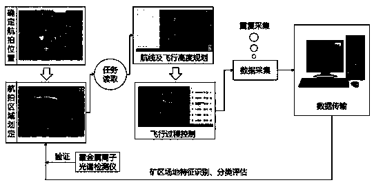
[0018] Example: A coal mine is located in a mountainous area, and the industrial square in the mining area is between two mountains. The satellite / airborne fusion method is adopted according to the figure 1 The technical process identifies the industrial site in the mining area.

[0019] 1) Obtain high-resolution remote sensing images of the mining area, understand the distribution of surface features in the industrial square of the mining area based on the high-resolution remote sensing images, and initially grasp the general location of the mine's industrial site; through the high-resolution images, it is known that there is a village A in the north of the mine's industrial site , There is village B in the west, road C is located in the south periphery of the industrial square, and the east is farmland area, so on the remote control display screen of the drone, village A, village B and the outer edge of road C are used as boundary points, and the east is about 20m away from t...


PUM


Abstract

The invention discloses a method for identifying field characteristics of a coal mine area through star/airborne image fusion. The method comprises the following steps: 1, selecting a flight site anda flight target plan according to a high-resolution remote sensing image; 2, planning the flight route and height of the unmanned aerial vehicle; 3, selecting a take-off point and controlling a flightprocess; 4, storing, transferring and analyzing aerial photography data of the unmanned aerial vehicle; and 5, mining area ground resource classification evaluation. According to the method, throughmutual cooperation of the high-resolution remote sensing images and the low-altitude unmanned aerial vehicle data, aerial photography display point drawing analysis is carried out on the coal mine industrial site according to the characteristics of the mining area industrial site, identification, classification and resource evaluation of the characteristics of the coal mine industrial site are achieved, the measurement and evaluation efficiency is improved, and high adaptability and popularization are achieved.

Description

technical field [0001] The invention relates to the field of unmanned aerial vehicle photogrammetry, in particular to a method for identifying coal mine site characteristics through fusion of satellite / airborne image data. Background technique [0002] With the massive mining of coal resources, resource-exhausted mines have increased significantly, forming a large number of mining sites. Mining sites not only have irreversible adverse effects on the natural environment, but also cause serious waste of resources. The identification and classification of industrial sites in mining areas and the assessment of industrial site resources are of great significance to the transformation, development and governance of mining areas. In the existing technology, the identification of mining areas is often based on the relevant information of on-site surveys by personnel. However, due to the large area of ​​mining areas and complex terrain , manual operations cannot effectively conduct ...

Claims


Application Information

Patent Timeline
Patent Type & Authority Applications(China)
IPC IPC(8): G06K9/00G06Q50/02G06Q50/26G01C11/00G01N21/25
CPCG06Q50/02G06Q50/26G01C11/00G01N21/25G06V20/13
Inventor 董霁红郭亚超张华黄艳利邹剑波
Owner CHINA UNIV OF MINING & TECH
Why Eureka
Try Eureka